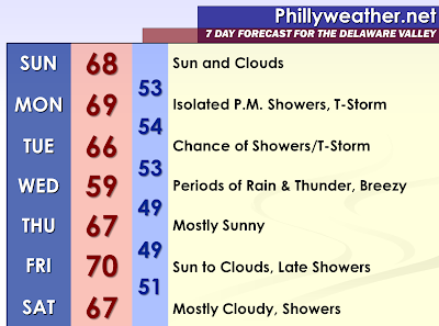

High pressure is currently anchored from Canada into the Eastern United States this evening. It will move eastward on Sunday and allow for a flow off of the ocean, meaning the moisture content of the air will begin to increase and it will remain cool. A cold front will move into the region from the west late on Monday and become nearly stationary on Tuesday. The front will slowly drift off the coastline on Wednesday, but it appears quite possible that a wave of low pressure develops along the front and moves northward. This signals a potential for a coastal low pressure system.
Tonight, with the loss of daytime heating, daytime cloudiness should diminish quickly. Mostly clear skies are expected and as a result of the high pressure area, temperatures should drop decently in areas that can radiate easily. Therefore, mid and upper forties will be the general rule of thumb in the suburban areas with lower fifties in the urbanized areas.
On Sunday, a few clouds are expected during the daytime hours with the increasing easterly flow, especially along the coastline. The cold front out to our west will likely approach the Ohio valley and Tennessee Valley on Sunday Night. Sunday Night should feature more clouds than stars. Highs will likely top out in the mid and upper sixties.
On Monday, the cold front makes the closest approach late in the day. Afternoon and evening isolated showers and possibly some isolated thunderstorms could occur. With highs in the mid and upper sixties, it does not currently appear as the most unstable setup. However, if some of the model guidance is warmer on Monday…there could end up being more instability…but this solution would likely mean a drier Monday. With the front drifting eastward and over the region on Tuesday, additional showers and thunderstorms will either be ongoing or will develop with afternoon daytime heating. Tuesday will be a relatively cool day with highs in the middle sixties.
With the cold frontal passage on Tuesday Night or Wednesday Morning, even cooler air will follow. This will be reinforced with the development of a coastal low along the nearly stationary front when it is offshore on Wednesday. Further impacting the temperature will be the extensive clouds and rain. The rain could be heavy at times, but the longer range modeling has backed off on the intensity of the low. Since it is spring, I will allow for some elevated thunderstorms development. It could also be breezy on Wednesday and later forecasts will likely take a closer look at any potential gusty winds or coastal impacts, if any. The next chance for showers is on Friday Night into Saturday.
You will hear more about a review of April 2011 here in a few days, but this is the first April in two years where we did not have a heatwave. We did not hit 90 degrees this month.
Tidak ada komentar:
Posting Komentar