The Storm Prediction Center has everyone from an Atlantic City-Wilmington line on north under a slight risk for severe weather. There's a fair bit of uncertainty about how dry we stay locally as guidance varies a fair bit between "storm" and "no storm" locally through today.
This morning, thunderstorms already grace the radar's presence with a complex of thunderstorm activity north of Toronto in Canada, sliding southeast. These storms will cross New York State this morning into the afternoon hours, perhaps setting up along the NY/PA border by afternoon given their trajectory. Whether the storms survive through the day or not is not important...this batch of storms or their remnant will be agitated and enhanced by improving dynamics later on, which means odds favor some thunderstorms along the NY/PA border towards mid afternoon, with them sliding south and southeast from there.
Most computer modeling (GFS, EURO) has us remaining dry through Midnight locally while the NAM shows the line of thunderstorms sneaking into the area late this afternoon and into the evening hours, from north to south and generally after 4/5 PM in the Poconos and after 8 or 9 PM locally in Philadelphia. While there are some aspects of some of the NAM modeling that are a bit off (the potential for a second complex of storms in one of the NAM's forecasts is a clear outlier to the other modeling and probably not likely), the timing element makes the most sense given location of storms at present and trajectory.
So, summing up all that, expect much of the day to be generally very warm and increasingly humid locally. We should be thunder free in Philadelphia through dinner but odds favor some storms after 8/9 PM in the city, after 4 PM in the Poconos. The strongest storms have the potential to drop hail and/or bring gusty winds with them and the "best" chances for the strongest storms will be to our north where instability will be a bit more sufficient for strong and severe thunder. As always, we'll update the thunder threat later on!
More: Current Weather Page
Tampilkan postingan dengan label severe thunderstorm discussion. Tampilkan semua postingan
Senin, 18 Juli 2011
Minggu, 17 Juli 2011
Chance of Severe Storms Late Monday
A weak frontal boundary will slide south, buoyed in the atmosphere by a disturbance that will track east along the front and act as a trigger for shower and thunderstorm development in the afternoon hours to our north. With additional heat and humidity in the atmosphere, there will be sufficient instability to fire off at least some thunderstorm activity to our north, and perhaps as well locally. The Storm Prediction Center has Pennsylvania and the northern two-thirds of New Jersey in a slight risk for severe weather on Monday.
The highest odds for severe weather reside over the twin tiers of Pennsylvania and New York -- with a 30% chance for severe weather within 2 miles along and north of I-80 to just north of I-86 in New York. Most of these storms will fire on the front edges of a decaying MCS that will likely track through the Great Lakes tonight. This MCS could spawn a line of scattered severe storms after midday that will slide southeast towards us. Given the timing and likely origin points of thunderstorms, we should be dry for much of Monday and start seeing an increased thunder threat in the Poconos after 3 PM, locally after 6 or 7 PM.
Higher resolution modeling is rather "ho hum" on thunderstorm chances locally -- while other models (GFS, NAM) at least paint a chance for thunderstorms across the region in the evening hours. This is an instance where the best chances for thunder will reside to our north...and if storms can hold together despite the timing working against us somewhat (evening time) we could get a few stronger rumbles of thunder as well.
We'll have an update on this in the morning.
The highest odds for severe weather reside over the twin tiers of Pennsylvania and New York -- with a 30% chance for severe weather within 2 miles along and north of I-80 to just north of I-86 in New York. Most of these storms will fire on the front edges of a decaying MCS that will likely track through the Great Lakes tonight. This MCS could spawn a line of scattered severe storms after midday that will slide southeast towards us. Given the timing and likely origin points of thunderstorms, we should be dry for much of Monday and start seeing an increased thunder threat in the Poconos after 3 PM, locally after 6 or 7 PM.
Higher resolution modeling is rather "ho hum" on thunderstorm chances locally -- while other models (GFS, NAM) at least paint a chance for thunderstorms across the region in the evening hours. This is an instance where the best chances for thunder will reside to our north...and if storms can hold together despite the timing working against us somewhat (evening time) we could get a few stronger rumbles of thunder as well.
We'll have an update on this in the morning.
Rabu, 08 Juni 2011
Strong Storms For Some Tomorrow Evening?
Our heat event is potent but not long lasting as relief will start to slide towards us in the form of a cool front tomorrow. This front will be a bit of a factor in the forecast over the weekend as it stalls out in the region and enhances the thunderstorm potential for Friday and Saturday before a second front comes in from the west and clears the coast late Sunday. As is the case with many summertime fronts the push of cool air is not impressive behind it but relief is relief even if the front stalls and brings thunder chances.
Since this front will cut into a hot and humid airmass the potential for thunderstorms exists tomorrow afternoon and evening. The best chances for storms to develop will be to our north and northwest and some of those storms could be strong if not severe. There is a slight risk of severe weather out for areas north of I-78 tomorrow, with the best chances of severe weather across Northern and Western Pennsylvania.
The timing may not necessarily be optimal for us to get severe weather locally as computer modeling suggests that most of the activity holds off from moving into Philadelphia until after 8 or 9 PM. The NAM computer model depiction up above is for 5 PM tomorrow from a forecast run from earlier today, showing thunderstorms generally are in greater quantity north and west of I-78 late tomorrow afternoon. Those storms will gradually slide into the Philadelphia region, perhaps not as strong as they will be over the Lehigh Valley or Poconos, but still enough to bring a taste of relief to the region after a flirtation with 100 degrees tomorrow afternoon.
Since this front will cut into a hot and humid airmass the potential for thunderstorms exists tomorrow afternoon and evening. The best chances for storms to develop will be to our north and northwest and some of those storms could be strong if not severe. There is a slight risk of severe weather out for areas north of I-78 tomorrow, with the best chances of severe weather across Northern and Western Pennsylvania.
The timing may not necessarily be optimal for us to get severe weather locally as computer modeling suggests that most of the activity holds off from moving into Philadelphia until after 8 or 9 PM. The NAM computer model depiction up above is for 5 PM tomorrow from a forecast run from earlier today, showing thunderstorms generally are in greater quantity north and west of I-78 late tomorrow afternoon. Those storms will gradually slide into the Philadelphia region, perhaps not as strong as they will be over the Lehigh Valley or Poconos, but still enough to bring a taste of relief to the region after a flirtation with 100 degrees tomorrow afternoon.
Rabu, 01 Juni 2011
Slight Risk of Severe Storms Later Today
A trough is moving into Pennsylvania this morning with little fanfare and little thunderstorm activity. However, as that boundary works east into a more favorable atmosphere the potential for thunderstorm development towards midday and into the early afternoon does exist. As instability will be quite high thanks to a decent amount of heat and humidity (especially in Pennsylvania) and dynamics aloft are somewhat favorable we are under a slight risk for severe weather for the region for today. The strongest of storms will produce damaging wind as an upper level jet streak works east in tandem with the trough. As thunderstorms develop, some of them will tap into the stronger winds aloft and pull some damaging wind gusts to the surface.
At minimum, storm development will be scattered in nature but it's completely possible that a line of thunderstorms develops later on today and slides southeast.
Higher resolution modeling suggests that thunderstorms will impact the Philly area between 2-4 PM, developing perhaps as soon as late morning or midday across Central Pennsylvania before sliding southeast.
This may not be a widespread severe event, however. One, last night's seabreeze front has helped push in some marine layer stratus along coastal sections of New Jersey. Depending on how long it takes for that marine layer to lift this morning, it is possible that thunderstorms along coastal sections of the Garden State may not be as robust as they were in Pennsylvania due to a more stable atmosphere along the coast. Pennsylvania seems to be more "under the gun" for stronger/severe storms than those east of, say, the New Jersey Turnpike based on this. If thunderstorm development occurs a little bit later on in the afternoon -- closer to dinner and not lunch -- the extra couple of hours of daytime heating may be enough to overcome the stable atmosphere along the coast this morning.
More: Current Weather Page
Selasa, 31 Mei 2011
Chance of Severe Storms Tomorrow
The Storm Prediction Center has the region under a slight risk for severe weather on Wednesday as the heat wave/heat event that we're currently dealing with comes to an end with the passage of a late day cool front and the weakening of the heat ridge over the Eastern US. This is another less-than-optimal setup for severe storms in that some parameters are rather impressive while others are screaming against severe storms.
The items for severe are the heat, humidity, and the development of a trough along the eastern edge of the Appalachians thanks to a wind shift line between west winds coming downhill and southwest winds at the surface, as well as temperature differences between the mountains and the lower elevations in Southeastern and South Central Pennsylvania. That trough develops in the late morning and early afternoon and acts as a focal point for at least scattered afternoon thunderstorms. These storms, given a fast wind environment aloft, could bring damaging winds and perhaps some hail, as they move east towards the region. The NAM, below, shows the thunder threat generally between 2 and 5 PM around the region, earliest to the west and northwest and latest across Delaware and South Jersey. The timing element is generally consistent across all major models -- generally the early and mid afternoon time frame around the region looks the most likely for any thunderstorm development to occur.
What is working against severe is the potential for surface winds to shift westerly a bit sooner and preclude any trough development downstream of the Appalachians. A west wind is typically not good for severe storm development in our world and even a southwest wind may keep thunderstorm development more scattered and less widespread. However, with temperatures in the 90's and dewpoints in the 65-68 range there's more than enough heat and humidity to provide the fuel for something to pop.
The items for severe are the heat, humidity, and the development of a trough along the eastern edge of the Appalachians thanks to a wind shift line between west winds coming downhill and southwest winds at the surface, as well as temperature differences between the mountains and the lower elevations in Southeastern and South Central Pennsylvania. That trough develops in the late morning and early afternoon and acts as a focal point for at least scattered afternoon thunderstorms. These storms, given a fast wind environment aloft, could bring damaging winds and perhaps some hail, as they move east towards the region. The NAM, below, shows the thunder threat generally between 2 and 5 PM around the region, earliest to the west and northwest and latest across Delaware and South Jersey. The timing element is generally consistent across all major models -- generally the early and mid afternoon time frame around the region looks the most likely for any thunderstorm development to occur.
What is working against severe is the potential for surface winds to shift westerly a bit sooner and preclude any trough development downstream of the Appalachians. A west wind is typically not good for severe storm development in our world and even a southwest wind may keep thunderstorm development more scattered and less widespread. However, with temperatures in the 90's and dewpoints in the 65-68 range there's more than enough heat and humidity to provide the fuel for something to pop.
Senin, 23 Mei 2011
Monday's Storm Discussion
Update, 6:45 PM: Eastern Lancaster and Southeastern York Counties are under a severe t-storm warning until 745 PM. Doppler radar has also indicated some weak rotation in this storm according to the statement.
Update, 6 PM: Storms are generally along and just east of the Susquehanna River, with a couple of pop up cells near Reading and near Chester respectively. The main line extends from just west of Lancaster to Bloomsburg in North Central Pennsylvania. All of that is moving east and northeast and is probably a couple of hours away from Philly and should cross the city by 9 PM (or so). The Severe Thunderstorm Watch in Central PA was extended a couple of hours, now out until 8 PM for the counties in Central Pennsylvania. Winds could gust to 45 mph with the storms and some vivid lightning can't be ruled out as well.
Update, 4:50 PM: SPC will be coordinating a new watch box along and east of thunderstorms between 5 p.m. and 6 p.m.
Update, 4:30 PM: Storms are starting to pop up across the region, with a tornado warning up between Harrisburg and State College for a storm that will track a good ways north of us. Closer to us, showers and storms are popping up near Lancaster and north of Baltimore, lifting northeast. This activity, plus the storms out west of York and in Northern Maryland, will be the activity to track over the coming hours as it moves east. The best odds of severe thunderstorms will generally reside along and west of I-95.

If you look at the temperature profile on the map above you can see that there is still some residual cool air lingering to the north and east of Philadelphia, with temperatures in the 60's across Bucks and into North Jersey. Severe chances will drop off quickly as the storms reach and breech the Delaware River later this evening thanks to the stable air in place. That doesn't mean a severe storm can't occur but the odds there are a good bit lower than they are in Chester, Lancaster, or in Berks Counties where the sun has been out a bit more this afternoon.

Across the region this morning, clouds have been hanging tight. On the latest satellite imagery, we are starting to note clearing in the southwestern portions of our region, moving up from Baltimore and Washington D.C. This area of sunnier breaks will continue to push northeast with the warm frontal passage into the early afternoon hours. I think the breaks will at least make it through Philadelphia and South-Central New Jersey.


The Storm Prediction Center this morning increased the percentage that severe thunderstorms would occur within 25 miles of a point in the western portions of our forecast area. 30% probabilities have been given to the western sections of our area. Due to the satellite depictions of where the breaks are beginning to occur, this seems to be very reasonable as these areas will be into the sunshine for the longest duration prior to convective development. With the clearing skies expected to make relatively good progress through the remainder of our area, the 15% probability for severe weather or the percentage that warrants a slight risk designation has been moved to include the rest of us not in the 30%.

Basically, this is how it works. 2% for tornadoes or 5% for damaging winds/large hail warrants a “see text”. A 15% or 30% for large hail/damaging winds or 5% or 10% for tornadoes warrants a “slight risk” designation for severe thunderstorms. A 45% for large hail/damaging winds or 15% for tornadoes warrants a moderate risk for severe thunderstorms.
With the warm front rising just above our region and the potential sunshine moving our way, we are in a very favorable quadrant for severe thunderstorms. Most times warm fronts do not have enough energy to produce much more than isolated convection to the south of the boundary. However, this is one of those scenarios where a wave of energy will ride along the front to cause the activity to be more widespread than usual. A similar situation developed last year when a warm front made it up to Southern New York and a severe threat developed (including tornadoes) in Northeast Pennsylvania and Northern New Jersey after sunshine developed. This is the concern I have for today. No doubt that this event will be driven by destructive sunshine.
Update, 6 PM: Storms are generally along and just east of the Susquehanna River, with a couple of pop up cells near Reading and near Chester respectively. The main line extends from just west of Lancaster to Bloomsburg in North Central Pennsylvania. All of that is moving east and northeast and is probably a couple of hours away from Philly and should cross the city by 9 PM (or so). The Severe Thunderstorm Watch in Central PA was extended a couple of hours, now out until 8 PM for the counties in Central Pennsylvania. Winds could gust to 45 mph with the storms and some vivid lightning can't be ruled out as well.
Update, 4:50 PM: SPC will be coordinating a new watch box along and east of thunderstorms between 5 p.m. and 6 p.m.
Update, 4:30 PM: Storms are starting to pop up across the region, with a tornado warning up between Harrisburg and State College for a storm that will track a good ways north of us. Closer to us, showers and storms are popping up near Lancaster and north of Baltimore, lifting northeast. This activity, plus the storms out west of York and in Northern Maryland, will be the activity to track over the coming hours as it moves east. The best odds of severe thunderstorms will generally reside along and west of I-95.

If you look at the temperature profile on the map above you can see that there is still some residual cool air lingering to the north and east of Philadelphia, with temperatures in the 60's across Bucks and into North Jersey. Severe chances will drop off quickly as the storms reach and breech the Delaware River later this evening thanks to the stable air in place. That doesn't mean a severe storm can't occur but the odds there are a good bit lower than they are in Chester, Lancaster, or in Berks Counties where the sun has been out a bit more this afternoon.

Across the region this morning, clouds have been hanging tight. On the latest satellite imagery, we are starting to note clearing in the southwestern portions of our region, moving up from Baltimore and Washington D.C. This area of sunnier breaks will continue to push northeast with the warm frontal passage into the early afternoon hours. I think the breaks will at least make it through Philadelphia and South-Central New Jersey.


The Storm Prediction Center this morning increased the percentage that severe thunderstorms would occur within 25 miles of a point in the western portions of our forecast area. 30% probabilities have been given to the western sections of our area. Due to the satellite depictions of where the breaks are beginning to occur, this seems to be very reasonable as these areas will be into the sunshine for the longest duration prior to convective development. With the clearing skies expected to make relatively good progress through the remainder of our area, the 15% probability for severe weather or the percentage that warrants a slight risk designation has been moved to include the rest of us not in the 30%.

Basically, this is how it works. 2% for tornadoes or 5% for damaging winds/large hail warrants a “see text”. A 15% or 30% for large hail/damaging winds or 5% or 10% for tornadoes warrants a “slight risk” designation for severe thunderstorms. A 45% for large hail/damaging winds or 15% for tornadoes warrants a moderate risk for severe thunderstorms.
With the warm front rising just above our region and the potential sunshine moving our way, we are in a very favorable quadrant for severe thunderstorms. Most times warm fronts do not have enough energy to produce much more than isolated convection to the south of the boundary. However, this is one of those scenarios where a wave of energy will ride along the front to cause the activity to be more widespread than usual. A similar situation developed last year when a warm front made it up to Southern New York and a severe threat developed (including tornadoes) in Northeast Pennsylvania and Northern New Jersey after sunshine developed. This is the concern I have for today. No doubt that this event will be driven by destructive sunshine.
Kamis, 28 April 2011
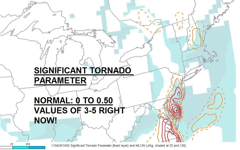
Severe Weather Reports for 4/28/2011
Tornado Damage in York County from earlier this morning.

Tornado Damage in York County from earlier this morning.
The severe weather today in our area was plentiful in our region (although nothing like the severe devistation in the Gulf States). Several thunderstorms did prompt tornado warnings across North-Central and Northeastern New Jersey, portions of the Lehigh Valley, and in South-Central Pennsylvania. There were numerous severe thunderstorm warnings issued throughout New Jersey.
In York County (we have a few readers there), the State College National Weather Service Forecast Office has confirmed an EF1 tornado. It occurred at Roundtop Mountain Resort in Fortney Township, Pennsylvania. This touchdown occurred around 5:55 a.m. today. It was 100 yards in width. Details on the max wind speed and length are listed as "to be determined". An EF1 tornado produces wind speeds of 86 to 110 MPH.
In Hunterdon County (New Jersey), a funnel cloud was reported in Alexandria Township. In Morris County, a funnel cloud was reported in Chester Township. In Passaic County, an impressive three funnel clouds were spotted at one time in Wayne Township. There were trees and power lines knocked down in Hunterdon and Morris Counties, including in Alexandria Township. WNBC in New York is reporting possible tornado damage in Denville Township. Jersey Central Power and Light’s online outage map did show several thousand in that area without power at one point in these areas. Of course, we will keep you updated if there is a report of an actual tornado touchdown in this area.
Update: Anthony Gigi told NJ.Com the following: "The reports that we are getting are more consistent with a severe thunderstorm rather than a tornado. We’re not seeing hundreds of trees down or roofs ripped off of homes."
Elsewhere, a tree fell down on a bus this morning in Berks County near South Heidelberg Township. In Mertztown large tree limbs were downed. In Jackson, Monroe County in Pennsylvania there was trees that were felled onto houses. Stroud Township also reported trees down. Wires were knocked down in Springfield Township in Bucks County. In Cumru Township in Berks County, trees were reported to be down. Hail was reported in Hunterdon County at White Horse Station which isn’t surprising to hear about when you have tornado characteristic thunderstorms. Trees and wires were taken down in Somerset County near North Plainfield Township.
More: Storm Damage Reports (NWS)
April 28, 2011 Severe Weather Coverage
2:38 radar update:

2:28: PHI issues Severe Thunderstorm Warning for Burlington, Monmouth, Ocean [NJ] till 3:30 PM EDT
2:03 Update: PHI issues Severe Thunderstorm Warning for Atlantic, Burlington, Camden, Gloucester [NJ] till 3:00 PM EDT
1:53 Radar Map:

1:28 p.m. UPDATE: Thunderstorms weakened a bit about an hour ago but are starting to hit the juicy air over Delaware and South Jersey. Due to the initial weakening trend, they have become less linear and more cellular/clustered. This likely enhances the tornadic threat and hail threat, but it will continue the downdraft potential. The latest radar trends showing 50-60 DBZ increases. Clearly, areas from the Delaware River and points east will be impacted for the next two to three hours.


12:29 p.m.: Look at the two mesoscale analysis maps I have posted just recently updated.

12:20 p.m. Update: Several dangerous thunderstorms continue to ride along the slow moving front with numerous severe t-storm warnings from Northeastern NJ down through areas just west of Philadelphia...and also NE MD and N DE.
11:03 a.m.: Tornado Warning for Northampton, Hunterdon, Warren, and Bucks Counties!
10:32 a.m.: Tornado Warning number three continues for Lancaster County---very strong rotation noted on doppler radar at times!
9:53 AM Update: A Severe Thunderstorm Watch is out for the region until 4 PM (see below). Lancaster County area has been in and out of tornado warnings for the last hour or two while Berks, Lehigh, and Lancaster area remains under severe t-storm warnings. Sunshine is out in parts of NJ and DE...could provide more fuel for storms.
Isolated tornadoes, despite this only being a severe t-storm watch, remain very possible....hence the warnings we have already had today.

Update, 9:40 AM: Wanted to point out the main action that will impact our region will be coming out of Maryland over the next hour or two as most of the storms in Lancaster County at present will slide to the north of the city. The line itself is moving east slowly while the individual thunderstorms on the line are moving northeast, which means that storms farther south will be the ones that ultimately impact us as the line gradually shifts east throughout the rest of the morning. One particular part of the line in Maryland has had a bit of a history of damaging winds and showing signs of tornadic rotation within it. That cell is circled on the radar map above. This cell will be working into Northern Maryland, then into Lancaster and Chester Counties over the next hour or two, perhaps into far upper Montgomery County if it can maintain itself. At minimum, damaging winds may be the result of that line of storms later on.
9:19 a.m.: Severe T-Storm Warning continues for Lehigh, Berks, and Lancaster Counties until 10:00 a.m.
9:04 a.m. Update: Tornado Warning has been allowed to expire for Lancaster County. A severe thunderstorm warning is in effect for Lancaster and Berks Counties.

9:00 a.m.:
A tornado warning was recently issued until 9:15 a.m. for Lancaster County. Get inside an interior closet or basement if you live near Strasburg or New Holland.

2:28: PHI issues Severe Thunderstorm Warning for Burlington, Monmouth, Ocean [NJ] till 3:30 PM EDT
2:03 Update: PHI issues Severe Thunderstorm Warning for Atlantic, Burlington, Camden, Gloucester [NJ] till 3:00 PM EDT
1:53 Radar Map:

1:28 p.m. UPDATE: Thunderstorms weakened a bit about an hour ago but are starting to hit the juicy air over Delaware and South Jersey. Due to the initial weakening trend, they have become less linear and more cellular/clustered. This likely enhances the tornadic threat and hail threat, but it will continue the downdraft potential. The latest radar trends showing 50-60 DBZ increases. Clearly, areas from the Delaware River and points east will be impacted for the next two to three hours.


12:29 p.m.: Look at the two mesoscale analysis maps I have posted just recently updated.

12:20 p.m. Update: Several dangerous thunderstorms continue to ride along the slow moving front with numerous severe t-storm warnings from Northeastern NJ down through areas just west of Philadelphia...and also NE MD and N DE.
11:03 a.m.: Tornado Warning for Northampton, Hunterdon, Warren, and Bucks Counties!
10:32 a.m.: Tornado Warning number three continues for Lancaster County---very strong rotation noted on doppler radar at times!
9:53 AM Update: A Severe Thunderstorm Watch is out for the region until 4 PM (see below). Lancaster County area has been in and out of tornado warnings for the last hour or two while Berks, Lehigh, and Lancaster area remains under severe t-storm warnings. Sunshine is out in parts of NJ and DE...could provide more fuel for storms.
Isolated tornadoes, despite this only being a severe t-storm watch, remain very possible....hence the warnings we have already had today.

Update, 9:40 AM: Wanted to point out the main action that will impact our region will be coming out of Maryland over the next hour or two as most of the storms in Lancaster County at present will slide to the north of the city. The line itself is moving east slowly while the individual thunderstorms on the line are moving northeast, which means that storms farther south will be the ones that ultimately impact us as the line gradually shifts east throughout the rest of the morning. One particular part of the line in Maryland has had a bit of a history of damaging winds and showing signs of tornadic rotation within it. That cell is circled on the radar map above. This cell will be working into Northern Maryland, then into Lancaster and Chester Counties over the next hour or two, perhaps into far upper Montgomery County if it can maintain itself. At minimum, damaging winds may be the result of that line of storms later on.
9:19 a.m.: Severe T-Storm Warning continues for Lehigh, Berks, and Lancaster Counties until 10:00 a.m.
9:04 a.m. Update: Tornado Warning has been allowed to expire for Lancaster County. A severe thunderstorm warning is in effect for Lancaster and Berks Counties.

9:00 a.m.:
A tornado warning was recently issued until 9:15 a.m. for Lancaster County. Get inside an interior closet or basement if you live near Strasburg or New Holland.
Thursday's Severe Weather Primer
Update, 7 AM: Storms have developed on the southern flank of the Central PA line and are sweeping towards the Philly region at this hour. Storm line extends from near Allentown south into extreme Northern Delaware and is moving northeast at 70 mph. This storm line has the potential to drop winds to over 60 mph due to its fast forward motion and the dynamic wind energy aloft and has resulted in severe thunderstorm warnings being issued for the northern and western suburbs. This warning is out until 8 AM. Rest of our initial post is below.
Today is shaping up as a rather active weather day on paper as the warmth and summery weather come to a halt thanks to a cold front's eastward march into the region. A line of rather nasty thunderstorms is setting up to our west, with severe thunderstorm warnings all along the line from Scranton down into Maryland, with the line slowly lifting northeast as the front is back in Western PA, slowly pressing east. This line will take a couple of hours to approach, and several hours to cross the region. Given the current timing and pace on radar, thunderstorms should work into the city towards mid morning and then clear the city during the mid or perhaps later afternoon. The thunderstorms you see on radar in Central Pennsylvania will not be the ones that hit us -- our activity is back in Virginia since these storms are lifting northeast. The Central PA storms will work through the Poconos over the next few hours, with the Virginia and Maryland activity moving in later on this morning.
With a line of nasty thunderstorms to the west and the atmosphere rather tropical, there is a threat for severe weather and the region is under a slight risk for severe thunderstorms through the day -- mainly with the Central Pennsylvania line this morning and then with the activity in Virginia as that approaches Philly later this morning and around midday. Thunderstorms have the potential to produce damaging winds, isolated tornadoes, and heavy rains. Flash flooding is a threat, mainly north of the city due to the damp soil conditions north of town, but the usual suspect streams and roadways that flood at a drop of a hat around here could have some issues later on if storms are strong enough.
A severe thunderstorm watch is out until 10 AM for the Philadelphia region and points west, north, and south. It wouldn't surprise me to see the watch reissued later on this morning, perhaps as a tornado watch depending on how nasty the Virginia and Maryland activity get over the next several hours (they are under a tornado watch until 8 AM).
Rabu, 27 April 2011
Thundery Day Turns To Thundery Night

11:57 p.m.: Severe Thunderstorm Watch now posted for Lancaster County and most of Central Pennsylvania.
11:30 p.m. Update: The Storm Prediction Center is suggesting in the latest mesoscale discussion a new weather watch...perhaps a tornado watch as they mention "all severe weather threats" will be possible in the early morning hours in Eastern and Central Pennsylvania. ~Doug

Update, 8:45 PM: Severe thunderstorm watch now issued for East PA and DE. Watch is out until 4AM. Higher threat for severe thunderstorms will be to the north and west of Philly but there is some chance for some storms to approach severe limits later tonight.
Update, 7:45 PM: The tornado watch is still out until 10 PM in Central Pennsylvania, with Flash Flood Watches for Thursday for the Lehigh Valley, Poconos, and North Jersey for tomorrow's storms. Radar up above is showing the activity lining up across Central Pennsylvania, with more activity down near Baltimore lifting northeast towards the Philly area. If they hold together, they should move through the region around 10 PM or so. As Doug pointed out below, we could see a tornado watch for Eastern PA, Maryland, and perhaps Delaware later on tonight as the storms down by Baltimore do have a history of some damaging winds and rotation within one of the storm cells.
7:00 p.m. Update: The Storm Prediction Center is considering a tornado watch later this evening as tornadic t-storms in Maryland and Central Pennsylvania may tend to move eastward in time...they may survive as eventual forcing gets closer along with increasing shear.

5:00 p.m. Update: Severe thunderstorm warning in effect until 515 Southwestern New Jersey. It did include parts of Delaware.
4:04 p.m. Update: Local National Weather Service says that there has been an injury this afternoon as a woman was struck by a tree in Camden County. The incident happened around 3 p.m.

3:30 p.m. Update: A flash flood watch has been issued for Thursday for the following counties: Mercer, Middlesex, Hunterdon, Carbon, Monroe, Northampton, and Lehigh Counties. Points to the immediate north of these counties are also under a flash flood watch.

3:13 p.m. Update: Lancaster County has now been put under a tornado watch which includes all of Central Pennsylvania. Earlier, a tornado watch was issued for Baltimore and Washington.

3:06 p.m. Update: According to the National Weather Service, a severe t-storm has been reported.

A severe thunderstorm warning has been issued for the Philadelphia Metro until 3:15, issued about 20 minutes ago.
Damaging winds up to 60 MPH are possible with this storm.
It will be near Philadelphia by 3:00 p.m.
Additional pop-up thunderstorms will develop this aftn and I will be updating this thread.
Not As Warm, Still Humid, Maybe Some Thunder
A warm, summery morning in the Delaware Valley as the sunny influences of Bermuda High pressure have waned somewhat and we're merely in a broad, tropical southwest flow ahead of a rather nasty storm system that is poised to move through tomorrow. Today's weather starts murky, humid, and warm and finishes that way as well, with temperatures approaching 80 away from the ocean, only getting to around 60 at the immediate Shore, as skies stay mostly cloudy and occasionally have some sunny breaks.
Some showers are showing up on radar across coastal sections of the region, with last night's thunderstorms to the west and north now out of the picture. The showers along and offshore will move northeast but with the heating of the day we should see a scattering of storms pop to our west and lift northeast. Yesterday's thunder threat was generally west of I-81 although a few storms last night managed to get into Allentown and Reading. Today's threat is generally higher west of I-95, although those coastal showers could be a bit more numerous later this morning as a weak disturbance slides up the coast 150 miles east of the NJ coastline. Storms will be prone to popping up after 3 or 4 PM but may end up being more numerous after sunset as storms farther southwest work their way towards us.
Areas to the west of Philly are under a slight risk for severe weather -- with the highest risk areas confined to the Tennessee Valley and Mid South as a high risk is out down there. Any thunderstorms that do develop this afternoon may have a better chance of producing heavier rains than severe wind gusts due to the amount of moisture in the atmosphere, although those gusty winds in the storms cannot be ruled out. Storm chances continue into the night, especially in Western Pennsylvania as the front and storm system begin to make progress towards the east, with the front crossing the region on Thursday afternoon. Thursday will probably be our area's best overall chance at heavy rain and severe weather.
We'll talk about Thursday's event in more detail this evening.
More: Current Weather Page
Some showers are showing up on radar across coastal sections of the region, with last night's thunderstorms to the west and north now out of the picture. The showers along and offshore will move northeast but with the heating of the day we should see a scattering of storms pop to our west and lift northeast. Yesterday's thunder threat was generally west of I-81 although a few storms last night managed to get into Allentown and Reading. Today's threat is generally higher west of I-95, although those coastal showers could be a bit more numerous later this morning as a weak disturbance slides up the coast 150 miles east of the NJ coastline. Storms will be prone to popping up after 3 or 4 PM but may end up being more numerous after sunset as storms farther southwest work their way towards us.
Areas to the west of Philly are under a slight risk for severe weather -- with the highest risk areas confined to the Tennessee Valley and Mid South as a high risk is out down there. Any thunderstorms that do develop this afternoon may have a better chance of producing heavier rains than severe wind gusts due to the amount of moisture in the atmosphere, although those gusty winds in the storms cannot be ruled out. Storm chances continue into the night, especially in Western Pennsylvania as the front and storm system begin to make progress towards the east, with the front crossing the region on Thursday afternoon. Thursday will probably be our area's best overall chance at heavy rain and severe weather.
We'll talk about Thursday's event in more detail this evening.
More: Current Weather Page
Selasa, 26 April 2011
Short Term Severe Threat for North and West Counties

11:35 p.m. UPDATE: Severe T-Storm Warning out for Berks and Carbon Counties...through 1230 a.m.


The Storm Prediction Center has issued a mesoscale discussion regarding several strong to severe thunderstorms brushing or soon to be brush our northwestern counties. There appears to be a wind damage threat for the next two hours and perhaps a brief rotating thunderstorm.
Sabtu, 23 April 2011
Slight Risk Potential Sunday
The Storm Prediction Center has us under a potential for some severe weather tomorrow as the much complained about front lurks around the region and a disturbance marches east-northeast along the front. As warmer air slides northward, the atmosphere from the Lehigh Valley on south on Sunday afternoon will become increasingly unstable and thunderstorms will be possible from the afternoon on.
Computer modeling suggests that the best thunderstorm chances will occur in the afternoon, with particular focus after 2 PM. The NAM is a bit earlier while the higher resolution variant of the NAM (below), which is a bit slower, pushes that focus towards dinner time. Balancing the two out suggests the best chances for thunderstorms will be in the mid afternoon hours, with the focus areas generally along the frontal boundary -- which should lie just to the city's north.
This may provide the season's first severe hail event as well -- the atmosphere has enough dynamics and instability aloft to support larger cumulonimbus clouds (thunderstorms), which can develop hail due to shooting higher into the atmosphere. Wind is also a threat (as is the case in most severe events). As the disturbance responsible for this thunderstorm event pulls through Sunday evening, the front may sag south Sunday night and on Monday just enough to cool some places from the city on north for the start of the work week...only briefly though as we'll warm back up for Tuesday.
Computer modeling suggests that the best thunderstorm chances will occur in the afternoon, with particular focus after 2 PM. The NAM is a bit earlier while the higher resolution variant of the NAM (below), which is a bit slower, pushes that focus towards dinner time. Balancing the two out suggests the best chances for thunderstorms will be in the mid afternoon hours, with the focus areas generally along the frontal boundary -- which should lie just to the city's north.
This may provide the season's first severe hail event as well -- the atmosphere has enough dynamics and instability aloft to support larger cumulonimbus clouds (thunderstorms), which can develop hail due to shooting higher into the atmosphere. Wind is also a threat (as is the case in most severe events). As the disturbance responsible for this thunderstorm event pulls through Sunday evening, the front may sag south Sunday night and on Monday just enough to cool some places from the city on north for the start of the work week...only briefly though as we'll warm back up for Tuesday.
Selasa, 19 April 2011
Slight Risk For Severe Tomorrow
You would think that today's chill and showers would lead to more chill and showers. For once, that's not the case. The stalled front is due to lift northward tomorrow and we should get into a several hour period of warmth during the midday and afternoon hours. Low pressure (which helps nudge the front north) will track east through the Great Lakes and along the NY/PA border tomorrow afternoon, dragging a cold front back through the region late tomorrow evening. This front will get agitated by the warm, unstable airmass between the warm front and cold front and the potential for severe weather exists in the region tomorrow afternoon and evening. The Storm Prediction Center has us in a slight risk for severe weather tomorrow, with a heightened risk for severe weather across the Delaware Valley down into Washington, DC.
Timing is everything, however, with the storms firing up and are dependent on sunshine plus warm sector influence. With that said, there's a good bit of pop in the atmosphere int he warm sector so there should be some activity for at least some folks. The thinking is the warm front should get north of the Lehigh Valley by midday and allow for enough warming for everyone to allow for thunder chances late in the afternoon. The NAM and higher res modeling suggests that this takes place between 4 and 7 PM in Philadelphia. The GFS and Euro are less enthusiastic on severe but highlight the potential for some showers and storms around the area.
Winds could gust to 50+ mph with the line of thunder as it forms. Hail does not seem likely at this point but any storms that do pop could not only drop strong winds but also heavy rain as they move east. Some poor drainage area flooding can't be ruled out tomorrow afternoon in some of the heaviest storms.
Timing is everything, however, with the storms firing up and are dependent on sunshine plus warm sector influence. With that said, there's a good bit of pop in the atmosphere int he warm sector so there should be some activity for at least some folks. The thinking is the warm front should get north of the Lehigh Valley by midday and allow for enough warming for everyone to allow for thunder chances late in the afternoon. The NAM and higher res modeling suggests that this takes place between 4 and 7 PM in Philadelphia. The GFS and Euro are less enthusiastic on severe but highlight the potential for some showers and storms around the area.
Winds could gust to 50+ mph with the line of thunder as it forms. Hail does not seem likely at this point but any storms that do pop could not only drop strong winds but also heavy rain as they move east. Some poor drainage area flooding can't be ruled out tomorrow afternoon in some of the heaviest storms.
Sabtu, 16 April 2011
Flood Watches Up N/W of I-95
A rather crappy weather day is about to unfold across the region as that significant storm system that brought tornado watches to nine states and dropped 80 reported tornadoes across the country is now setting its march on the Mid Atlantic. While tornadoes are not likely by any stretch here, a rather wind swept and rainy Saturday afternoon and evening is. The likelihood for at least an inch of rain for nearly everyone, with some two inch amounts north of the city, is setting up the possibility of some flooding in some locations. Flood Watches are out for places north/west of I-95 in Pennsylvania, Delaware, and New Jersey for tonight as soil conditions are still moist and a heavy shot of rain is expected in short duration this evening.
Radar (below) this morning is showing the first waves of rain moving into the area from the west. We should be able to coax a few dry hours this morning before showers spread in later, followed by heavier rains as we work towards dinner. The worst of the storm won't be until this evening -- but a six hour period from 6 PM - Midnight will provide a rather wild stretch of rain, thunder, perhaps strong gusty winds in those storms.
A slight risk of severe weather is out for Delaware, Southwest New Jersey, and South Central Pennsylvania -- generally points south and west of the city -- as a bit of a low pressure wave rides along the advancing front today and helps enhance thunderstorm activity. North of the wave, rain may be heaviest and those two inch amounts of rain could fall across Eastern Pennsylvania and Northwest New Jersey. South/east of the wave is where thunderstorms could bring some strong wind gusts to the mix. The GFS (below) shows the heavy rain blob generally north of the Philadelphia area at the height of the storm, between 8 and 11 PM. Over an inch of rain may fall in just three hours. The Euro (not shown) also is suggesting the heaviest of rains ride north/west of the city along and north of this wave of low pressure.
The NAM is showing the potential for torrential rains south/east of the low. While that's possible, the NAM does have a tendency to overdo thunderstorm-induced rainfall. It's possible that the storms may be wild and wacky, the rainfall results may not be as robust south of the city as they are to the north.
In a nutshell, expect a breezy and raw Spring day. Conditions will continue to go downhill as the storm moves in later on, with rain increasing in coverage later on today and becoming heavy at times towards dinner. Thunderstorms can't be ruled out and some of the storms will be pretty nasty from the city on south.
More: Current Weather Page
Radar (below) this morning is showing the first waves of rain moving into the area from the west. We should be able to coax a few dry hours this morning before showers spread in later, followed by heavier rains as we work towards dinner. The worst of the storm won't be until this evening -- but a six hour period from 6 PM - Midnight will provide a rather wild stretch of rain, thunder, perhaps strong gusty winds in those storms.
A slight risk of severe weather is out for Delaware, Southwest New Jersey, and South Central Pennsylvania -- generally points south and west of the city -- as a bit of a low pressure wave rides along the advancing front today and helps enhance thunderstorm activity. North of the wave, rain may be heaviest and those two inch amounts of rain could fall across Eastern Pennsylvania and Northwest New Jersey. South/east of the wave is where thunderstorms could bring some strong wind gusts to the mix. The GFS (below) shows the heavy rain blob generally north of the Philadelphia area at the height of the storm, between 8 and 11 PM. Over an inch of rain may fall in just three hours. The Euro (not shown) also is suggesting the heaviest of rains ride north/west of the city along and north of this wave of low pressure.
The NAM is showing the potential for torrential rains south/east of the low. While that's possible, the NAM does have a tendency to overdo thunderstorm-induced rainfall. It's possible that the storms may be wild and wacky, the rainfall results may not be as robust south of the city as they are to the north.
In a nutshell, expect a breezy and raw Spring day. Conditions will continue to go downhill as the storm moves in later on, with rain increasing in coverage later on today and becoming heavy at times towards dinner. Thunderstorms can't be ruled out and some of the storms will be pretty nasty from the city on south.
More: Current Weather Page
Minggu, 27 Februari 2011
More Rain, More Storms, More Warmth Monday
Another strong storm system will push through the Northeast and the slight risk of severe weather continues to hold for the Mid Atlantic. The highest odds for severe weather will be to our south and west but around here there is a 15% chance that severe weather could occur near the city. For February, it's impressive to have two slight risks in four day's time around these parts. With a warm surge of temperatures and instability pushing north ahead of a strong storm system, the atmosphere will be ripe for storms but also heavy rain.
Rain could be significant across the Mid Atlantic with the storm impacting us in two waves. The first, in association with a warm front, brings more rain to the north and west of the city than elsewhere but rain and some spring-like thunder can't be ruled out after midnight from southwest to northeast across the region. Rainfall could total an inch across parts of Central into Northeastern Pennsylvania overnight and during the morning hours on Monday. We probably will not see that type of rainfall tonight around Philadelphia but we could see a period of rain/thunder to start off Monday.
The warm front lifts north and Southeastern Pennsylvania, Central and South Jersey, and Delaware will get into a break between round one (warm front-enhanced rains) and round two (cold front). Rains may continue across the Poconos and Central Pennsylvania, perhaps grazing the Lehigh Valley and Berks from time to time on Monday. The "break" is critical for severe weather prospects as computer guidance is hinting at soaking thunderstorms developing or moving in after 4 PM. If we get enough sunshine we could see temperatures approach 70 in Philadelphia (record high is 68) but even without sun, we should get into the 60's. With an unstable atmosphere and decent dynamics aloft, the potential does exist for those storms to pop. If you look at the higher resolution radar below you can see the heaviest activity is across South Jersey, Delaware, and Maryland. The activity over Maryland will spread into Southeastern Pennsylvania over the course of the early evening.
With the storminess developing along the front and lifting northeast as the front slides east, the potential for upwards of two inches of rain exists for some parts of the region from tomorrow's storms. The heaviest rain may ultimately fall in pockets as the cold front enhanced storms may develop in segments and not a solid line that sweeps through and hits everyone (see the precip totals on the graphic above), typical of a more "summery" thunderstorm setup.
We'll have another update in the morning hours on Monday.
More: Current Weather Page
Rain could be significant across the Mid Atlantic with the storm impacting us in two waves. The first, in association with a warm front, brings more rain to the north and west of the city than elsewhere but rain and some spring-like thunder can't be ruled out after midnight from southwest to northeast across the region. Rainfall could total an inch across parts of Central into Northeastern Pennsylvania overnight and during the morning hours on Monday. We probably will not see that type of rainfall tonight around Philadelphia but we could see a period of rain/thunder to start off Monday.
The warm front lifts north and Southeastern Pennsylvania, Central and South Jersey, and Delaware will get into a break between round one (warm front-enhanced rains) and round two (cold front). Rains may continue across the Poconos and Central Pennsylvania, perhaps grazing the Lehigh Valley and Berks from time to time on Monday. The "break" is critical for severe weather prospects as computer guidance is hinting at soaking thunderstorms developing or moving in after 4 PM. If we get enough sunshine we could see temperatures approach 70 in Philadelphia (record high is 68) but even without sun, we should get into the 60's. With an unstable atmosphere and decent dynamics aloft, the potential does exist for those storms to pop. If you look at the higher resolution radar below you can see the heaviest activity is across South Jersey, Delaware, and Maryland. The activity over Maryland will spread into Southeastern Pennsylvania over the course of the early evening.
With the storminess developing along the front and lifting northeast as the front slides east, the potential for upwards of two inches of rain exists for some parts of the region from tomorrow's storms. The heaviest rain may ultimately fall in pockets as the cold front enhanced storms may develop in segments and not a solid line that sweeps through and hits everyone (see the precip totals on the graphic above), typical of a more "summery" thunderstorm setup.
We'll have another update in the morning hours on Monday.
More: Current Weather Page
Langganan:
Postingan (Atom)