Locally, we're going to experience a very warm if not hot (depending on how you like it) day as temperatures climb into the lower and middle 90's under mostly sunny skies for much of the day. Today and tomorrow's heat are in advance of a cool front that will cross the region and slice temperatures back into the much more comfortable 80's for the remainder of the week.
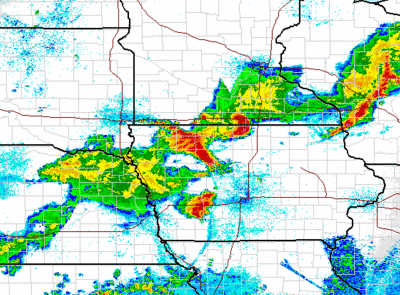
Computer guidance is hinting at the potential of thunderstorms being a part of the local forecast for tonight. These storms may ultimately be traced back in the Northern Plains and are currently in the Upper Midwest (see the radar shot below for a very early morning look). Their quick movement will take them through the Great Lakes today and while these initial storms may not survive the trek through the rest of the country, associated outflow boundaries from the storm combined with daytime heating later today through the Midwest and Lakes could agitate another line of storms or re-energize this line.
Computer guidance from the GFS and NAM suggest that some thunder could track into the region late this afternoon and across the region tonight -- timing is to be determined but as of early this AM I would think the best chances would be after 6/7 PM west, after 9/10 PM in/around the city. Locally, we should be able to get through most of the evening with dry weather although it will be quite warm. The chance for storms could linger into the pre-dawn hours at the Shore before the storms pull away, setting us up for a hot Tuesday.
We'll update tonight's thunder threat later on this afternoon.
Senin, 11 Juli 2011
Langganan:
Posting Komentar (Atom)


Tidak ada komentar:
Posting Komentar