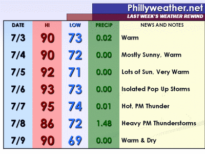
Temperatures last week averaged out to 4.9 degrees above where they should be for this time of the year...thanks mainly to six 90 degree days over the course of the week (which also featured a 93 and 95 degree high in there for good measure) as we had our longest stretch of 90 degree weather so far this year (five in a row). While most of the week was dry, we did dodge drops on Wednesday (mostly south/east of town), Thursday (a larger portion of the region), and Friday (most everyone) from afternoon thunderstorm development. Thursday's storms were potent in some spots around today but Friday's had much more bite as the city picked up nearly an inch and a half of rain.
Despite the bonanza of rain in Philadelphia and in South Jersey, areas north and west of town are still quite dry and did not pick up average rains over the course of the week (about three quarters of an inch of rain) -- the northern/western burbs have been in a localized dry spell going back to Spring and despite Friday's rains more could be used locally. Check out the map below from NOAA for more information on how dry things have been (red shades are less than 100% of normal rain over a seven day period).
Minggu, 10 Juli 2011
Langganan:
Posting Komentar (Atom)


Tidak ada komentar:
Posting Komentar