Tampilkan postingan dengan label tornado. Tampilkan semua postingan

Rabu, 18 Mei 2011

Tornado Touchdown in Northeast Philly

Earlier this afternoon a reported confirmed EF-0 tornado pulled the roof off of a beer distributor in Northeast Philadelphia.   The tornado may have touched down in Northeast Philly and darted northwest into Montgomery County, generally through Lower Moreland.

EF-0 tornadoes are the weakest on the "Enhanced Fujita" scale.   It's the ninth tornado to hit the city since 1950.

"It blew the roof off and pretty much totaled the place," said Gloria Deckard of the Beer Hut to Philly.com, clearing out what could be salvaged. "It just went through and got us."


Radar from 1:45 PM showed the thunderstorm cell which showed the potential to drop a tornado in Northeast Philadelphia.  This cell lifted northwest and sparked the tornado warning for Montgomery and Bucks Counties earlier this afternoon.  Heavy rain from the storm caused some flooding in parts of Abington earlier this afternoon, with a car submerged for a time along Route 63.

Showers and storms continue to propagate around in spiral bands, one currently extending from the Chesapeake through Central Pennsylvania with another one up near New  York City and North Jersey.  The potential for heavy rains will continue in those bands for the next few hours as they continue to move NW.   More rain in Delaware should spin through Philadelphia although the threat for severe weather and flooding will be lowered as this next band is not quite as potent as the earlier activity.

More:   CBS 3

Kamis, 28 April 2011

April 28, 2011 Severe Weather Coverage

2:38 radar update:


2:28: PHI issues Severe Thunderstorm Warning for Burlington, Monmouth, Ocean [NJ] till 3:30 PM EDT

2:03 Update: PHI issues Severe Thunderstorm Warning for Atlantic, Burlington, Camden, Gloucester [NJ] till 3:00 PM EDT

1:53 Radar Map:


1:28 p.m. UPDATE: Thunderstorms weakened a bit about an hour ago but are starting to hit the juicy air over Delaware and South Jersey. Due to the initial weakening trend, they have become less linear and more cellular/clustered. This likely enhances the tornadic threat and hail threat, but it will continue the downdraft potential. The latest radar trends showing 50-60 DBZ increases. Clearly, areas from the Delaware River and points east will be impacted for the next two to three hours.


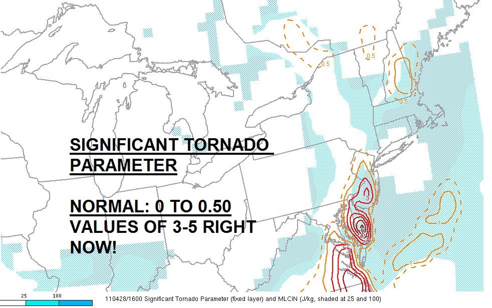
12:29 p.m.: Look at the two mesoscale analysis maps I have posted just recently updated.


12:20 p.m. Update: Several dangerous thunderstorms continue to ride along the slow moving front with numerous severe t-storm warnings from Northeastern NJ down through areas just west of Philadelphia...and also NE MD and N DE.

11:03 a.m.: Tornado Warning for Northampton, Hunterdon, Warren, and Bucks Counties!

10:32 a.m.: Tornado Warning number three continues for Lancaster County---very strong rotation noted on doppler radar at times!

9:53 AM Update:  A Severe Thunderstorm Watch is out for the region until 4 PM (see below).   Lancaster County area has been in and out of tornado warnings for the last hour or two while Berks, Lehigh, and Lancaster area remains under severe t-storm warnings.   Sunshine is out in parts of NJ and DE...could provide more fuel for storms.

Isolated tornadoes, despite this only being a severe t-storm watch, remain very possible....hence the warnings we have already had today.


Update, 9:40 AM:   Wanted to point out the main action that will impact our region will be coming out of Maryland over the next hour or two as most of the storms in Lancaster County at present will slide to the north of the city.   The line itself is moving east slowly while the individual thunderstorms on the line are moving northeast, which means that storms farther south will be the ones that ultimately impact us as the line gradually shifts east throughout the rest of the morning.   One particular part of the line in Maryland has had a bit of a history of damaging winds and showing signs of tornadic rotation within it.  That cell is circled on the radar map above.  This cell will be working into Northern Maryland, then into Lancaster and Chester Counties over the next hour or two, perhaps into far upper Montgomery County if it can maintain itself.  At minimum, damaging winds may be the result of that line of storms later on.

9:19 a.m.: Severe T-Storm Warning continues for Lehigh, Berks, and Lancaster Counties until 10:00 a.m.

9:04 a.m. Update: Tornado Warning has been allowed to expire for Lancaster County. A severe thunderstorm warning is in effect for Lancaster and Berks Counties.


9:00 a.m.:

A tornado warning was recently issued until 9:15 a.m. for Lancaster County. Get inside an interior closet or basement if you live near Strasburg or New Holland.

Kamis, 24 Maret 2011

Hail To The Sleet

Last night's thunderstorms were pretty "fun" to watch move through -- arguably less fun to drive through as the pinging of graupel, sleet, and hail hit windshields throughout the Delaware Valley during the 7:15-8:15 PM timeframe.   The National Weather Service is defining what fell last night as hail -- some places with slightly larger hail pellets than others -- but most of the reports that came in last night were classified as quarter inch hail.


One could realistically argue a case for sleet or graupel (hybrid of hail/sleet) as the precipitation type last night that fell -- the pellets that were falling were larger than traditional sleet pellets but weren't as "hard" as regular hail pellets...which makes me think a fair bit of graupel was falling in spots.  Hail certainly was do-able in many locations with these thunderstorms -- they were the remnant of severe thunderstorms that dropped a tornado across Western Pennsylvania (more on that in a bit) but given there was pretty significant instability aloft as well as cold pockets of air above a shallow mild layer in the bottom parts of the atmosphere the potential for sleet mixing in was legit, especially over the northern burbs as surface temperatures were in the 35-40 range during the event.

It can hail with temperatures in the 30's...it can sleet with temperatures in the 40's at the surface.   In this case, with temperatures around 40, it's possible we had both.


Dude...get inside the school...that's a tornado!   Yes, this tornado struck Hempfield High School in Greensburg, PA (out near Pittsburgh) yesterday afternoon with the complex of storms that hit Philadelphia later on last night.   While the caption in the linked video says he "overreacted" the best thing to do in a tornado is find shelter, even if it is in a large building (interior hall, basement if possible) as opposed to try to outrun it.  

From snow to thundersleet to hail, yesterday was a wild weather day in Pennsylvania -- especially since we had such a huge variation in weather over a short distance -- from 9-10" of snow in the Poconos to temperatures in the low 70's in Southwestern Pennsylvania.  Those types of extremes over 250 miles are "typical" of wacky early Spring storms.