Tampilkan postingan dengan label severe weather discussion. Tampilkan semua postingan

Jumat, 08 Juli 2011

Potential Dry Spell Buster On Tap Today

It's going to be a busy weather day in some parts of the Delaware Valley today as thunderstorms are poised to develop along a stalled out frontal boundary.   Given a rather moist atmosphere, the sufficient trigger in place, and the enhancement of a weak surface low moving along the frontal boundary and you have a recipe for a healthy couple of rounds of storms to fire up.  Additionally, the upper levels are stagnant (not a lot of wind aloft) so any storms that do develop will move pretty slowly this afternoon.   Factored together, the stage is set for not only some strong/severe thunderstorms (gusty winds are the likely culprit) but very heavy rainfall in some of those storms could yield quick rising streams and ponding of water on roadways.

A slight risk of severe is in place south of a line from Sandy Hook, NJ to York, PA -- including Philly and most of suburban Southeastern Pennsylvania for those gusty winds in the stronger of storms.   Also, a flash flood watch is out for the counties shaded in green on the map below, including Philly and its suburbs, Trenton, AC, and Wilmington.

Radar this morning already has some shower and storm activity -- as the day progresses the numbers of thunderstorms will increase and with the weak surface low tracking along the stalled front, we could see the potential for a widespread round of thunder breaking out along and south of the front this afternoon.  The highest odds for thunderstorms to track this afternoon are along and south of the PA Turnpike and I-195.   Timing suggests the brunt of the storminess occurs between 2 and 11 PM in/around the city, 3-Midnight in New Jersey and points south.  It might not storm the entire time but it is the time frame with the best chances of thunder.


The higher resolution modeling (below) suggests two rounds around the region -- the first in the 3-6 PM range (see above) with the weak surface low getting agitated by daytime heating, and the second round from activity in West Virginia and Virginia in the late afternoon tracking across New Jersey and Delaware in the late evening (9-Midnight).   The other computer modeling out there suggests a slightly different placement on thunderstorms but in general they all suggest a late afternoon/evening/early overnight time frame for activity.

The heaviest of thunderstorms could bring 2-4" of rain in isolated locations...others will probably not get anything, especially if you are farther north of the city.   The strongest of storms could bring wind gusts over 50 mph as well.

More:   Current Weather Page

Kamis, 09 Juni 2011

Severe Thunderstorm Watch Until 10 PM

Update, 8 PM: Storms are now moving into Philly and while they have weakened slightly they still pop a nice bit of bang with them. Expect gusty winds potentially some hail with them as they work east and southeast through the city and into South Jersey over the next few hours.   The storm trend is to slowly weaken as they move southeast but severe warnings will probably continue to be issued with these down to the coastline.

Update, 7 PM:  A couple of severe thunderstorm warnings now out for the north/west suburbs of Philadelphia -- until 7:30 for Upper Chester and Montco, until 7:45 for Bucks.   The individual cells are still scattered about but the gaps between them are closing somewhat as they move east-southeast.   These storms are about an hour to 90 minutes from Philadelphia.   So far, these storms have produced very strong winds but are capable of also dropping large hail.


Update, 5:45 PM:  While Philly and other locations "enjoy" another record setting day in the temperature department radar is showing the scattering of thunderstorms across Central PA that I hinted about at 4 PM.   Storms near Harrisburg and over the mountains north of I-78 in Schuylkill County are moving east and becoming the "main" action that we'll see in a couple of hours.   These storms have been dropping hail and gusty winds and will continue to march east.   Notice that they are scattered -- some of us will not get much in the way of thunder unless these storms coalesce into one line...the scattered organization means some will get hit, others may miss.

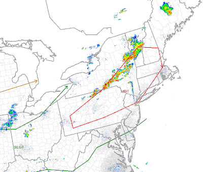
Update, 4 PM:   Radar below is depicting a nice line of thunderstorms, not all of which are severe, from north of Scranton back to just east of Pittsburgh.   As you can see, there is a good bit of real estate between us and the bad weather and it's going to be a few more hours before thunderstorms approach the region.     The storms across Northern Pennsylvania are the worst of the lot at this point but the storms to our west have gone severe from time to time as they move east.    Storms could still pop up ahead of this line and from time to time there are indications that storms are trying to do that in Central Pennsylvania.  However, even the scattered storms ahead of the line are still three hours away if not more from getting into the area.   Storms aren't sweeping through at any quick rate of speed -- 20-30 mph is about all they are doing this afternoon.


2:50 p.m. UPDATE:

A severe thunderstorm watch is now in effect for much of our region until 10 p.m. Hail to 2 inches in diameter and wind gusts up to 80 MPH are possible.

A Severe Thunderstorm Watch for is now in effect for Atlantic, Burlington, Camden, Cape May, Cumberland, Gloucester, Hunterdon, Mercer, Middlesex, Monmouth, Morris, Ocean, Salem, Somerset, Sussex, Warren counties in New Jersey, New Castle County in Delaware, and Berks, Bucks, Carbon, Chester, Delaware, Lehigh, Monroe, Montgomery, Northampton, Philadelphia counties until 10:00 p.m. An earlier watch includes Lancaster County.


The Storm Prediction is monitoring our region for a severe weather watch...most likely to be issued within the next two hours.

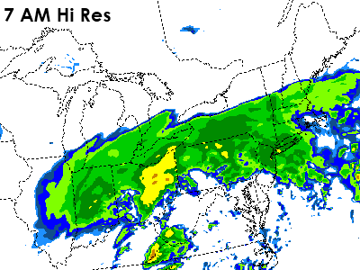
Explosive severe thunderstorm development is occurring in New York and Pennsylvania early this afternoon. This line will continue to increase in size, developing into a pretty potential squall-line of severe thunderstorms. Dew points are currently in the upper sixties and lower seventies ahead of the developing line of thunderstorms. Air temperatures are in the mid to upper 90’s across the entire region with some areas not sitting at 100 degrees. With a few more hours of sunshine, prior to the arrival of the potential squall-line, additional places will near 100 degrees with some areas potentially exceeding it.

There is extremely high surface based CAPE values in place this afternoon for our region due to the excessive heat and humidity. CAPE values are 3,500 J/kg to 5,500 J/kg, with the highest values in the North and Western suburbs.

Downdraft CAPE is 700 J/kg to 1,000 J/kg. The Derecho Composite is indicating 4 to 6 values which is an indicator of a decent damaging wind threat. Large hail parameters are checking in at 1 to 1.5 this afternoon, which is also running higher than what would be normal for our local severe weather standards. Therefore, some thunderstorms could produce large hail…possibly very large in size…but overall damaging winds (with the potential for some destructive, 70 MPH or greater wind gusts) is the primary threat.

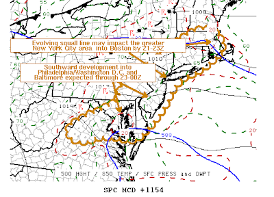
Portions of the Lehigh Valley, Poconos, and Northern New Jersey have been placed in an unusual moderate risk for severe thunderstorms. Elsewhere, there is a slight risk for severe thunderstorms.

Rabu, 01 Juni 2011

This Afternoon's Severe Discussion

Update, 5:30 PM:   The "line" of thunderstorms is now just two thunderstorm cells -- one across Central Jersey and about to hit the Atlantic, with the second cell down near Wilmington in Delaware.   The Central Jersey cell did work through the Trenton area and had a severe warning with it for a time, with the cell in Wilmington also warned across Chester County earlier on this afternoon.   At this point, the storm threat is generally down to the Wilmington cell as dry air is beginning to approach the region.  Dewpoints drop from 71 in Reading to 64 in Harrisburg to the 40's in Western Pennsylvania, with the "trough" that was going to be the trigger for thunderstorm development now generally overhead and working east.


Update, 4:30 PM:   We're seeing a bit of a regenesis in the storm activity, especially in Bucks into Mercer Counties where a severe warning is now out.   Scattered activity is continued on back to the west into Chester County but the storms farther west, at this point, aren't as strong.

Update, 3:30 PM:   The "line" I talked about earlier has fallen apart a good bit -- looking at some of the atmospheric data one would think the potential would really exist -- there is a lot of atmospheric juice and instability.  Dynamics aloft, however, aren't as favorable.  The upper level jet that was modeled to be overhead today is instead a bit farther north, with lighter winds aloft at the surface and a less optimal setup for severe around here.  


Radar is showing a bit of a weak trough/boundary line across the northern/western suburbs.   Nothing has popped from it yet but if anything does fire development could be quick as it may be a focal point for localized thunderstorm development later on.   Unfortunately, things are "stuck" because of a less than favorable upper level of the atmosphere as winds aloft may not be strong enough to help aid in storm development.

Update, 2:45 PM: A couple of smaller storms have started to pop around the city and suburbs. Nothing severe at this point in the city or suburban counties (not including Berks/Lehigh, which are both under warnings until 3:45 PM) but the earlier mentioned line of storms that developed along the lee trough have gotten a bit better organized and now generally extend from Stroudsburg to Allentown to Reading and farther south and then west. We'll probably see that line continue to fill in as it moves east and more storms continue to pop ahead of the line in the next hour.


Lots of stuff to talk about this afternoon!   Not only do we have the heat warning but we have two severe weather watches out there.   First, a Severe Thunderstorm Watch until 5 PM for Central into Northeast Pennsylvania, with a Tornado Watch out until 8 PM for the Philadelphia area on north.

A supercell thunderstorm fired up across Central Pennsylvania and zipped east into Northeast PA early this afternoon.  That cell will pass through North Jersey and towards the northern NYC suburbs over the next couple of hours.   Our development is setting up out near Harrisburg, along the "lee" trough that develops along and just east of the Appalachian Mountains, where you get a bit of a dry line between slightly cooler/less humid mountain air and the moist, humid air that can pool across Central and Southeastern Pennsylvania.   Thunderstorms are starting to fire up and will gravitate east over the next few hours, with the Philadelphia region's best chance for thunder generally between 3 and 6 PM, possibly a bit later than that to our east.

Damaging winds are more likely than tornadoes but a tornado can't be ruled out -- the Storm Prediction Center has Philly and points north in a 5% chance area whereas damaging wind has a 30% chance of verifying within 25 miles of one's spot.   Regardless, expect storms to continue to pop over the coming hours and work towards the region, with our best chances of getting hit after 3 PM.

It also would not surprise me if some sort of watch gets issued for Delaware, Maryland, and the rest of South Jersey within the next hour or two.

Update, 2:30 PM:   Severe Thunderstorm Watch now out for South Jersey and Delaware (basically the rest of the region not under the Tornado Watch) until 10 PM.

We'll have updates within this post as the afternoon progresses.

More:   Current Weather Page

Selasa, 03 Mei 2011

Thunder Threat Later Tonight

There is a window of opportunity for some stronger storms later tonight -- generally after the Phillies game in the city and after 9 or 10 in Eastern and South Central Pennsylvania.  A severe thunderstorm watch is out until 10 PM for areas north and west of suburban Philadelphia.    Thunderstorms are lined up across Central Pennsylvania -- generally west of I-81 -- and are slow moving, with flash flood warnings out along the line across much of Central Pennsylvania.

At current rate, the worst of the heavy rain and thunder will stay west and northwest of Philadelphia but there is a chance for some thunderstorms to develop along the front across Maryland later tonight and work their way northeast into Philadelphia, especially after Midnight, if some of the higher resolution guidance is correct. I don't anticipate those storms to be severe on a widespread scale but heavy rain can't be ruled out.

The bigger story with the front is tomorrow's temperatures, which may not reach 60 during the day north and west of the city.   Our highs for Wednesday will probably be reached at 1 AM (midnight standard time), perhaps in the 70's depending on rainfall timing, with daytime temperatures staying in the 50's for much of the day before reaching 60 in the afternoon as sun pops out later in the day.

More:   Current Weather Page

Southern Discomfort

Image courtesy of NWS Birmingham
Over 300 fatalities, pummeled sections of real estate throughout more than a dozen states, and countless videos showing Mother Nature in a wrath-induced spat.   Last week's tornadic outbreak has been rightfully compared to the Super Outbreak of April 1974, not just in numbers of tornadoes but in terms of loss of life.  What makes this outbreak more amazing is that fatality trends have generally decreased over the last 30-40 years.    The current fatality tally of 348 in just four months this year is the most the US has seen in any one year since 1974 (366 died that year) and the second most since 1953 (519 that year).

Much talk has been given to the tornado that leveled Tuscaloosa, Alabama.  Brian Yang at the National Center for Atmospheric Research captured the radar imagery of the supercell that developed and dropped the long track tornado that tracked through not only Tuscaloosa but almost made it all the way to Birmingham, about 60 miles to its northeast.   Even after the tornado lifted, damaging winds continued on the track through Northeast Alabama and into North Georgia, a total track of damage and destruction of over 400 miles by the time it was all done.


Tang has also posted a really incredible radar loop video on his Facebook page which shows the storms tracking through the South last Wednesday.

Capital Weather Gang discussed the outbreak yesterday with more in depth information -- but they also shared a satellite loop of last week's severe weather outbreak via video (see below) as administered by NOAA's Earth Observatory website.   The worst of the outbreak was on Wednesday and you can see how the interaction of a jet streak (watch the high clouds work east along the Gulf Coast at eight seconds into the loop) into the developing storm system during the early hours of Wednesday fueled the explosive development of thunderstorms along the cold front.


Our region also received some tornadic impacts from this storm system, with five tornadoes touching down in Central Pennsylvania and one weak tornado in Northeastern Pennsylvania on Thursday morning.

Selasa, 26 April 2011

Thunder Chances Before Thursday's Main Event

The current severe weather event across the central portions of the country is rather amazing -- the damage in St. Louis to their airport last Friday, the run of storms through Arkansas yesterday, and over 15" of rain in some portions of the Ozarks from the current pattern has been remarkable to watch unfold. This storm system is finally easing east and will work towards us for Thursday. However, it will be close enough to us tomorrow to increase the odds of thunder around the region.


A slight risk of severe weather was placed out for the region for Wednesday for areas west of Philadelphia, with the highest concentration of severe thunderstorms in the Ohio Valley down into the Mid South, including Nashville, Louisville, and parts of Alabama.   Our severe risk is more for Wednesday night if the storms move quickly enough, with the main focus area for severe weather on Thursday positioned squarely over the top of us as the front closes and crosses the region.

Despite the worst of storms being to our west tomorrow, there will be an added risk for showers and thunderstorms as the atmosphere is increasingly unstable the mid level cap that was over us on Monday and most of Tuesday weakens as high pressure's grip over the region weakens somewhat.   The strong southwest flow at the lower levels and mid levels of the atmosphere will help tug tropical moisture that is east of Florida and Georgia northward into the region on Wednesday.  This will increase the thunder risk and probably lower our daytime temperatures by several degrees.  While it will still be warm, the additional clouds will keep us from getting into the 80's like we have the past three days.   Some showers and storms will develop and move through the region over the course of the day, some of which may produce heavy rainfall due to the quasi-tropical airmass that will be in place.


Storms will be scattered in nature and move through from southwest to northeast during the day and ahead of Thursday's main event, which continues to show signs of being a rather potent event whether it be a wind threat or heavy rain threat...both of which are definitely possible as a squall line may develop along the cold front Thursday afternoon.

Hopefully you have been able to enjoy most of the past three days -- while the weather hasn't been 100% perfect all of the time the past few, it's been the best weather we've had in a while.  Unfortunately, things will head downhill from here...especially on Thursday.

Senin, 25 April 2011

Ending Early Summer

After a multi-day run of 80+ degree weather around these parts, all good things must come to an end for a time. A stronger cold front will finally move into the region on Thursday after weaker boundaries failed to push into the Bermuda High in the Atlantic. This stronger storm system will not only end the 80 degree warmth but also bring a potentially nasty round of thunderstorms to the region -- if the timing is right.


Computer modeling consensus suggests the front passes through the region around midday Thursday -- the Euro and NAM computer models are latest and suggest a Thursday PM timeframe (more optimal for bad storms) while the GFS suggests a morning timeframe.   Storms that develop could bring strong gusty winds but given the setup of the storm system (shifting winds aloft) some tornadoes can't be ruled out.   Plenty can change given we're three days out but the setup, on paper, looks good for at least some severe weather around the region on Thursday.   We'll update the potential as we get closer but it looks like summer's first foray in the region could end with a few pops and bangs.

Before that, however, there is a chance for some thunderstorms on Wednesday as the humid airmass that's moving north could pull some tropical moisture into the region from a disturbance that's down in the Bahamas at present.   The tropical disturbance won't become a tropical storm or anything of the sort but it could enhance some thunderstorms in parts of the region on Wednesday afternoon.

Senin, 11 April 2011

Strong Evening Storms Possible N & W

 
In addition to today's run towards record warmth the potential exists for severe weather across Pennsylvania. Today's warmth is brought to you by an advancing cold front that, as of this morning, is back across Michigan and Northwestern Ohio.  It's going to march on east today and take its thunderstorms with it.  By dinner time, thunderstorms should be on the march across Central Pennsylvania and given the warm, unstable air ahead of the front (temperatures in the 80's in Pennsylvania, dewpoints around 60) thunderstorms have the potential to be severe with damaging wind gusts.  

Higher resolution radar below shows the storms by 8 PM bisecting the state.  The higher res radar might be a bit slow with the eastward progression compared to the GFS and Euro but it's not enough of a difference as far as we're concerned in terms of timing, track, and intensity.  Storms should hold off in Central Pennsylvania until dinner time, perhaps after that if the high res radar is closer to being right, with thunderstorms not moving into Philadelphia until after 9 or 10 PM tonight, meaning we should be able to coax a decent early evening of activities outside before rumbles of thunder approach.


The severe potential is higher to our west today due to timing and better dynamics.  The atmosphere will have had some time to settle down here this evening before thunderstorms move in, plus the proximity of a mid 40 degree ocean will help to stabilize the atmosphere just enough to prevent real nasty stuff around here.  Strong, gusty winds are still possible but the worst of the thunderstorm activity will likely be across Central and Western Pennsylvania.

Selasa, 05 April 2011

The End of This Warmth

Update, 7 AM:   The watch in Pennsylvania have been dropped as the band of rain and wind have moved out of the state and into New Jersey.   No warnings are out at 7 AM but the threat for a brief strong wind gust and a 15 minute shot of heavier rain remain.   Some of the stronger dynamics associated with the storm line have weakened and the line is not quite as potent as it was a couple of hours ago.

Update, 5:05 AM: Severe Thunderstorm Watch issued until 10 AM for the Philadelphia region (counties in the "red" color on the map below).   The highest potential for gusty winds are in the Philadelphia region, Delaware (under a tornado watch until 10 AM), and New Jersey over the next two to three hours as the storms begin to march east.   The orange shading down by Wilmington and in Chester County are for severe thunderstorm warnings that are out until 6:15 AM.


Tornado Watches to our south, temperatures near 70 in the Delaware Valley at 5 AM, and a squall line to end our recent Spring Fling.   Aw, volatile weather in Spring...there's nothing like it in Philadelphia.   The southern parts of the region are waking up to a tornado watch until 10 AM (Delaware), with a gusty line of rain and thunder marching steadily east and northeast through the Mid Atlantic this morning.   This line should begin to work into the western suburbs over the next 30-45 minutes and hitting Philadelphia in the 6 AM hour, with South Jersey getting hit by 7:30.   Storms could gust to over 50 mph and a weak tornado could spin up due to some limited wind shear within the thunderstorms.   While, for now, the Philadelphia area is not under a watch we do run the risk of getting in on some of the stronger wind gusts with these storms as they are nudging northeast along the eastward moving front.

These storms will impact the region this morning and will slap the region with a return to reality as temperatures will fall from near 70 to the upper 40's to around 50 degrees by around midday, with temperatures only nudging slightly higher late this afternoon with some sunshine possibly returning towards dinner.  After the squall line crosses the region, a period of rain will persist through midday before ending.  The region should see about a half inch, with some isolated higher rainfall totals that could approach an inch of rain, from this morning's storms.

You can track the progress of the storms across the region on our current weather page.

Kamis, 24 Februari 2011

Soaking, Windswept, Perhaps Thundery

The next 24 hours will bring a soaker of a storm through parts of the Delaware Valley, with the potential for a couple of inches of rain expected to our north.   As a result, flood watches are out north and west of Philadelphia for tonight and Friday for the potential of heavier rains that could cause localized flooding of streams and roadways.   Around Philadelphia, this looks like a storm that will bring about an inch of rain, perhaps a touch more than that, as rain will pick up in earnest after 9 PM from southwest to northeast.    Light at first, it will become steadier and heavier after 2 AM tonight as a warm front lifts northward into the region and enhances precipitation that is currently falling.    The heaviest rain should be anticipated in a couple of rounds -- first of which is between 2 and 9 AM as the warm front lifts northward, bringing more moisture and rising temperatures towards morning.

As the warm front lifts through Philadelphia, south winds will increase the dewpoint and humidity and we'll break for a bit between the first round and the surface low, which will enhance precipitation towards midday.   Rain after the first slug will probably be a bit more showery in nature and less steady.    However, winds will increase in the warm sector so it will be a bit of a rainswept afternoon.   There could be a couple of rumbles of thunder towards midday, especially south and west, with the showers as they develop and lift northeast in the unstable airmass.


The higher resolution guidance and a couple of the computer models are hinting strongly at the potential for a bit of a squall line in the afternoon hours across Pennsylvania, Maryland, Delaware, and New Jersey.   This is somewhat sunshine plus dry dependent -- if we can get a few hours of drier weather in the afternoon ahead of the cold front that trails the low, we could see a squall develop in Western Pennsylvania and march east through mid/late afternoon.   While the high res guidance suggests a 6 PM timing for Philadelphia, it would not surprise me if this were clearing the coast by 6 PM and moving into the western burbs shortly after 3 PM.   Temperatures could spike to near 60, perhaps warmer if we get more than a glance at the sun tomorrow afternoon, before the front and the potential squall line hit.


The squall line will bring some rather gusty winds to the equation -- perhaps reaching 60 mph in thunderstorms or in unassociated wind gusts after the front crosses by.   A high wind warning is out for the entire region for Friday afternoon and evening for the potential of those excessive wind gusts.  Even if 60 mph gusts don't verify, sustained winds of 20-35 mph in the afternoon and evening are certainly quite windy.

We'll have an update in the morning on where things stand and on the potential for the stronger storms in the afternoon hours tomorrow.