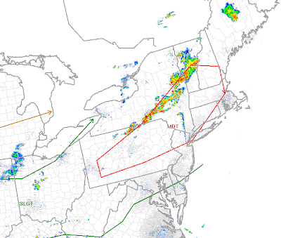
Update, 7 PM: A couple of severe thunderstorm warnings now out for the north/west suburbs of Philadelphia -- until 7:30 for Upper Chester and Montco, until 7:45 for Bucks. The individual cells are still scattered about but the gaps between them are closing somewhat as they move east-southeast. These storms are about an hour to 90 minutes from Philadelphia. So far, these storms have produced very strong winds but are capable of also dropping large hail.
Update, 5:45 PM: While Philly and other locations "enjoy" another record setting day in the temperature department radar is showing the scattering of thunderstorms across Central PA that I hinted about at 4 PM. Storms near Harrisburg and over the mountains north of I-78 in Schuylkill County are moving east and becoming the "main" action that we'll see in a couple of hours. These storms have been dropping hail and gusty winds and will continue to march east. Notice that they are scattered -- some of us will not get much in the way of thunder unless these storms coalesce into one line...the scattered organization means some will get hit, others may miss.
Update, 4 PM: Radar below is depicting a nice line of thunderstorms, not all of which are severe, from north of Scranton back to just east of Pittsburgh. As you can see, there is a good bit of real estate between us and the bad weather and it's going to be a few more hours before thunderstorms approach the region. The storms across Northern Pennsylvania are the worst of the lot at this point but the storms to our west have gone severe from time to time as they move east. Storms could still pop up ahead of this line and from time to time there are indications that storms are trying to do that in Central Pennsylvania. However, even the scattered storms ahead of the line are still three hours away if not more from getting into the area. Storms aren't sweeping through at any quick rate of speed -- 20-30 mph is about all they are doing this afternoon.

2:50 p.m. UPDATE:
A severe thunderstorm watch is now in effect for much of our region until 10 p.m. Hail to 2 inches in diameter and wind gusts up to 80 MPH are possible.
A Severe Thunderstorm Watch for is now in effect for Atlantic, Burlington, Camden, Cape May, Cumberland, Gloucester, Hunterdon, Mercer, Middlesex, Monmouth, Morris, Ocean, Salem, Somerset, Sussex, Warren counties in New Jersey, New Castle County in Delaware, and Berks, Bucks, Carbon, Chester, Delaware, Lehigh, Monroe, Montgomery, Northampton, Philadelphia counties until 10:00 p.m. An earlier watch includes Lancaster County.


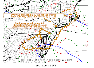
The Storm Prediction is monitoring our region for a severe weather watch...most likely to be issued within the next two hours.
Explosive severe thunderstorm development is occurring in New York and Pennsylvania early this afternoon. This line will continue to increase in size, developing into a pretty potential squall-line of severe thunderstorms. Dew points are currently in the upper sixties and lower seventies ahead of the developing line of thunderstorms. Air temperatures are in the mid to upper 90’s across the entire region with some areas not sitting at 100 degrees. With a few more hours of sunshine, prior to the arrival of the potential squall-line, additional places will near 100 degrees with some areas potentially exceeding it.
There is extremely high surface based CAPE values in place this afternoon for our region due to the excessive heat and humidity. CAPE values are 3,500 J/kg to 5,500 J/kg, with the highest values in the North and Western suburbs.
Downdraft CAPE is 700 J/kg to 1,000 J/kg. The Derecho Composite is indicating 4 to 6 values which is an indicator of a decent damaging wind threat. Large hail parameters are checking in at 1 to 1.5 this afternoon, which is also running higher than what would be normal for our local severe weather standards. Therefore, some thunderstorms could produce large hail…possibly very large in size…but overall damaging winds (with the potential for some destructive, 70 MPH or greater wind gusts) is the primary threat.
Portions of the Lehigh Valley, Poconos, and Northern New Jersey have been placed in an unusual moderate risk for severe thunderstorms. Elsewhere, there is a slight risk for severe thunderstorms.


Tidak ada komentar:
Posting Komentar