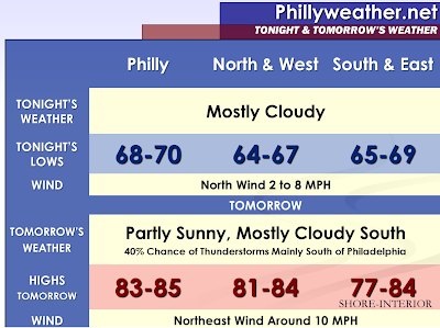

A cold front will swing through the region this evening. While there is a slight chance of showers and thunderstorms with the passage of the front, the main focus along the front will be with waves of low pressure riding along it. At this point, it appears that all three of these waves of energy will be passing south of our region and affect primarily Baltimore, Washington, Georgetown, and Salisbury with the most widespread activity. South of the Atlantic City Expressway, you may be close enough to the energy for a pop-up thunderstorm. I feel the northern counties will be too far away from the focus mechanism for thunderstorm initiation and may actually be well into the drier atmospheric conditions behind the front by Sunday Afternoon.
This front will return as a warm front, most likely an active warm front, Monday Night into Tuesday. Periods of showers and thunderstorms will accompany the front. If the region enters the warm sector and remains just south of the warm front…some strong to severe thunderstorms would become a possibility in addition to efficient rainfall producers on Tuesday. The guidance is diverging and painting various solutions as to the location of the warm front. If the warm front manages to lift well north of the region, then the chances of thunderstorms could be for less than six hours with the passage of the front and will not be more than isolated during the day on Tuesday.
Wednesday, if not Tuesday, we will likely see the warm front lift far enough north… so that the forecast area is entrenched into the warm sector. This means uncomfortable, warm, and humid conditions are likely. If full sunshine occurs on Wednesday and Thursday, we could see even hot weather conditions with high temperatures in the nineties.
There are some models indicating that the warm front has difficultly budging northward the entire week, but lifting it just far enough northward to keep us in the favorable quadrant for frequent thunderstorms and severe weather episodes. For now, I will side with the solution of keeping the frequent thunderstorm development to the north of Philadelphia as has been the trend for the past few months. I will include some pop-up thunderstorms, especially for the northwestern counties, as we have seen some of the past similar situations result in nasty thunderstorms between Reading, Lancaster, and Mount Pocono.
A cold front is expected to swing through our area on Friday. This will likely bring another chance for showers and thunderstorms and this chance could be more inclusive of the entire region.
Tidak ada komentar:
Posting Komentar