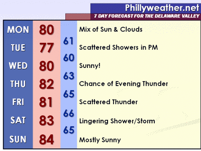
Our humid morass will come to a needed end this evening as a cool front crosses the region in the next several hours. Despite a chance of early evening thunderstorms that accompany the front, the bigger story will be the reduction of humidity and the more tolerable weather that will follow in the front's wake for the next few days.
Temperatures will take a dip as well, dropping to around 80 or into the 70's for the next few days as some Canadian air slips south into the region. With the cooler air aloft and at the surface, plus a couple of weak upper level disturbances that will dip southeast from Canada in the upper level flow, scattered showers and storms could pop on Monday and Tuesday afternoon around the region. Monday's shower threat is generally confined to areas north of I-78, with Tuesday's threat a bit more widespread in the afternoon hours.
Monday's temperatures should range from the upper 70's north to around 80 locally and points south. Shower development for northern areas should generally occur after 2 PM. For the rest of us, a mix of sun and clouds should provide a rather nice respite from the humidity of the last several days.
Week Ahead: After Tuesday's scattered shower/storm activity, Wednesday shapes up as the most "nice" day of the coming week as highs top out around 80 with lots of sunshine. A storm system will work into the Mid Atlantic for late Thursday and Friday, bringing more thunderstorm chances to the region, mostly in a scattered fashion. Some storms could linger around into Saturday as computer modeling is undecided on how quickly the system moves through. Temperatures will hang out around 80 for much of the week.
Minggu, 12 Juni 2011
Langganan:
Posting Komentar (Atom)


Tidak ada komentar:
Posting Komentar