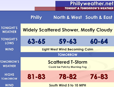

A low pressure area moving away from the Great Lakes is currently pushing a convective complex southeast towards Pennsylvania, Virginia, Maryland, and New Jersey. The complex is weakening. The current radar imagery is showing that the once heavy and organized showers are breaking up and becoming widely scattered. Therefore, only some widely scattered showers are anticipated this evening and perhaps some patchy fog very late tonight and overnight. The humidity and dew point temperatures remain relatively low, although they have begun to respond to the moisture attempting to squeeze in here from the disturbance. Dew point temperatures as of late afternoon were rising into the middle fifties, up from the upper thirties just twenty-four hours ago. However, they will need to reach 65 degrees before we really begin to feel the conditions outside become uncomfortable. With the afternoon cloudiness, weak forcing, and dew points in check…the thunderstorm threat tonight will remain west of our area. The Convective Available Potential Energy is non-existent over our area with the stability in place. You have to go out to Ohio and Western Pennsylvania for the first signs of Surface Based CAPE.
The best chance of showers and thunderstorms this weekend will be from later Sunday Afternoon into Sunday Night with a cold front. The amount of sunshine is in question for Sunday, but there should be some peaks of sunshine through the clouds. We could have a few strong thunderstorms to contend with if all of our cards are played just right. Tomorrow’s convective potential will be examined in the morning once visible satellite trends are evaluated to see how many breaks in the clouds develop. The Storm Prediction Center places areas that are west of the Delaware River and Chesapeake Bay under a 5% probability or a see text designation of severe thunderstorms for Sunday in their day two outlook. The NAM model suggests the activity lingering into early Monday, especially east of Philadelphia.
The latest computer modeling is hinting at some energy impacting our region on both Monday Afternoon-Evening and Tuesday Afternoon-Evening. There is the potential for a few showers or thunderstorms to potentially develop as a result of disturbances. Overall, I expect these to be widely scattered and many locations to continue to remain relatively dry. This could be a lot of like our previous events where very few communities get a downpour. I am going with very isolated and slight chances of 20% right now in the forecast.
I have noted the convection trend over the past two months. The thunderstorms seem to have great difficulty developing in or moving into the southeast areas of our target audience. The latest model guidance wants to suggest that folks south of Burlington and Ocean Counties get zero to a few tenths of rain for the next few events with the main impact in the northern and central areas where we forecast for.
A cold front could possibly move into the region late this week. Another trend for this pattern...that has become noticeable... is that the models are too fast with fronts in the long range and that sometimes these fronts end up washing out, allowing the heat to build and linger in our area. It could get quite warm and humid ahead of this front on Thursday and Friday, before it attempts to move through. If it fails to move through…then the second heat wave of the season would be upon us. Timing has implications of thunderstorm chances and temperatures. I will be forecasting 90 degree readings in this forecast for Thursday and Friday. Saturday could be much hotter than the present forecast of allowing the front to sweep through and bring in a cooler flow if this front slows down or washes out.
Tropics:
We will be watching an area of low pressure south of Jamaica. This has been given a 30% chance at developing into a tropical or subtropical cyclone within the next 48 hours. This system is weak currently and shows no explosive thunderstorm development (which would suggest strengthening if it was explosive). Once it becomes organized, if it ever does, the models will likely handle it much better with regards to track and intensity…and then we can determine if the system will pose any risk to United States interests.
Marine:
Winds will be light with 5 to 10 knot speeds. Seas will be 2 to 3 feet with isolated maximum waves up to 3.5 or 4 feet. There will be more of an easterly component to the wind direction during the start of the week. There is a green light for small crafts, unless a thunderstorm can manage to move offshore late Sunday into Monday Morning which could prompt a special marine warning.
Tidak ada komentar:
Posting Komentar