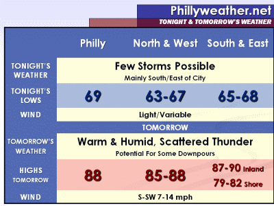
An advancing cool front will cross the region tomorrow evening while a warm front tied to the front lifts northward this evening and overnight. The two of them will tandem together to bring thunder threats to the region -- first from the warm front tonight and then from the advancing cool front on Tuesday. With the latter, localized downpours are possible in locations throughout the region with afternoon thunderstorm development.
Tonight, however, brings a few thunderstorms to the region with the warm front lifting northeast. Odds are favoring the storms generally across New Jersey and Delaware this evening and overnight as the warm front lifts northeast but a few could sneak into Pennsylvania as well. Temperatures tonight drop into the mid and upper 60's in many locations. On Tuesday, the advancing cool front will trigger scattered afternoon and evening thunderstorms that could bring heavy downpours in spots...if not some localized severe weather in others. Highs on Tuesday will range from around 80 at the Shore to 85-90 inland, with upper 80's expected around Philadelphia.
Week Ahead: After tomorrow's thunder, a trio of nice days are likely as temperatures hang in the mid and upper 80's with modest humidity levels. Thunder chances return for the 4th of July weekend in advance of a cool front. Ahead of the cool front, a couple of 90 degree days can't be ruled out on Saturday and Sunday. We'll continue to update the 4th of July forecast as we approach the holiday weekend.
Senin, 27 Juni 2011
Langganan:
Posting Komentar (Atom)


Tidak ada komentar:
Posting Komentar