
It is turning out to be a more comfortable 4th of July weekend than many forecasters had anticipated. Model projections were calling for lower nineties and dew points in the mid-sixties for the majority of the late afternoon hours today. But, as of 5:00 p.m., temperatures were in the mid to upper eighties with dew point readings in the mid and upper fifties. Isolated locations may briefly pop-up to ninety degrees within the next hour, before falling back. Pottstown did reach 91 degrees at 354 p.m., but with a dew point reading of 52 degrees at that time. Observations suggest a pocket of 48-52 degree dew points in the Reading area. A sea-breeze front is also moving inland and cooling off coastal and eastern interior Southern New Jersey at this hour....but causing dew points to approach 60 with oceanic moisture.
A cold front approaching from the west will probably begin to bounce the dew point temperatures up as the boundary forces more moisture our way. The mixing for the day will also end within the next few hours, contributing to higher moisture content at the surface. Therefore, it will become more humid as the night progresses. A weak boundary could trigger a spotty a.m. t-storm.
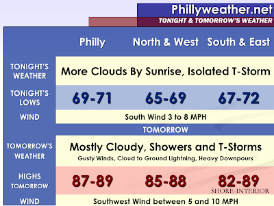
The convective debris from the cold front induced thunderstorms currently spreading into the Ohio Valley will move eastward into our area by sunrise. Some of the model guidance is even indicating some scattered thunderstorms around in Central Pennsylvania. This will likely mean that Sunday Morning will start off with quite a few clouds in the suburbs of Philadelphia, perhaps extended further east. Sunshine will peak through the clouds from Philadelphia and points to the east, increasing the instability ahead of the cold front. Cumulus clouds will bubble up ahead of the front and ongoing debris clouds will aid in filtering out the sunshine to some degree. Therefore, I anticipate that many locales will not hit 90 degrees tomorrow. I have dropped our high temperature expectation into the upper eighties. Tomorrow will be humid though creating some discomfort.
Showers and thunderstorms are expected to already be ongoing and push eastward, slowly, throughout the daytime hours. They could arrive by early afternoon in Reading and Allentown and arrive by late afternoon and early evening in Philadelphia, Trenton, and Wilmington with the remainder of the coastal communities perhaps seeing thunderstorms by sunset. Thunderstorms will have difficulty producing severe elements. Temperatures aloft don’t appear to supportive of large hail as the freezing level is up there. Shear looks minimal, which is needed for sufficient storm organization to produce damaging wind gusts. I suspect the majority of thunderstorms that do form will produce 25 to 45 MPH wind gusts and small hail. The greater threat will be frequent lightning and heavy rainfall. Lightning has caused numerous injuries and even a death this year in our area, so a storm does not have to be severe to cause danger. The Storm Prediction Center has placed the region in a 5% risk for severe weather within 25 miles of a point as one or two storms could achieve marginal severe limits.
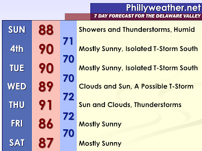
Much like the previous week, the front is anticipated to put on the brakes south of our region. A few waves will ride along the front, bringing shower and thunderstorm chances to the Delmarva and points south for Independence Day and Tuesday. It will still be hot, but I think dew points will be in check with the front south of the region. Should the front not be as far south, then it would be more unsettled closer to home and more humid here. Assuming the front does clear Philadelphia, sunshine should push us to around 90 degrees on Monday and Tuesday since there is not much cooler air behind the front.
Unfortunately, the broken record continues. The stalled front returns into our region as a warm front on Wednesday. Once again, it could bring a round of showers and thunderstorms with some having the potential to become severe and spin around the warm front vicinity. 80% of the current guidance shows convection being confined to the southern areas later on Wednesday. A wide variety of solutions exist for the warm front location by late Wednesday and on Thursday. This lends to low confidence on temperatures and convective elements for this period.
A cold front is expected to move from northwest to southeast on Thursday Afternoon into Thursday Night. I will assume that the area will be within the warm sector by this point. If that is the case, some sunshine may break out adding to instability. The forcing mechanism should create thunderstorms in the area if that is the case. What I can’t assume at the present time is if the warm front will be close enough to the cold front to increase the opportunity for severe weather more than it probably is going to be.
If you have your laptop at the ocean front this weekend, reading our discussion and forecast, you may have had an opportunity to go into the water. Water temperatures are well above average for their early July normal. Readings are in the middle to upper seventies. The normal increases into August and September, before the start of a downward trend. Typically, water molecules take time to heat up and time to cool off, a basic Physics principle and that is why the warmest water temperature may not coincide with the warmest day. Anyway, the reason I mention this is that there is the possibility of going up much further from here since the normal values would suggest that they will only increase. This is something to keep in mind for the approaching months of August and September as hurricane season begins to ratchet up.
Tidak ada komentar:
Posting Komentar