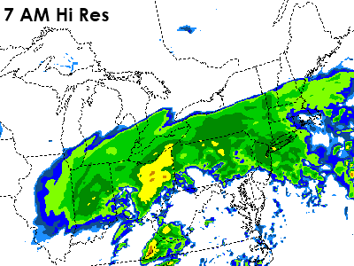
The next 24 hours will bring a soaker of a storm through parts of the Delaware Valley, with the potential for a couple of inches of rain expected to our north. As a result, flood watches are out north and west of Philadelphia for tonight and Friday for the potential of heavier rains that could cause localized flooding of streams and roadways. Around Philadelphia, this looks like a storm that will bring about an inch of rain, perhaps a touch more than that, as rain will pick up in earnest after 9 PM from southwest to northeast. Light at first, it will become steadier and heavier after 2 AM tonight as a warm front lifts northward into the region and enhances precipitation that is currently falling. The heaviest rain should be anticipated in a couple of rounds -- first of which is between 2 and 9 AM as the warm front lifts northward, bringing more moisture and rising temperatures towards morning.
As the warm front lifts through Philadelphia, south winds will increase the dewpoint and humidity and we'll break for a bit between the first round and the surface low, which will enhance precipitation towards midday. Rain after the first slug will probably be a bit more showery in nature and less steady. However, winds will increase in the warm sector so it will be a bit of a rainswept afternoon. There could be a couple of rumbles of thunder towards midday, especially south and west, with the showers as they develop and lift northeast in the unstable airmass.
The higher resolution guidance and a couple of the computer models are hinting strongly at the potential for a bit of a squall line in the afternoon hours across Pennsylvania, Maryland, Delaware, and New Jersey. This is somewhat sunshine plus dry dependent -- if we can get a few hours of drier weather in the afternoon ahead of the cold front that trails the low, we could see a squall develop in Western Pennsylvania and march east through mid/late afternoon. While the high res guidance suggests a 6 PM timing for Philadelphia, it would not surprise me if this were clearing the coast by 6 PM and moving into the western burbs shortly after 3 PM. Temperatures could spike to near 60, perhaps warmer if we get more than a glance at the sun tomorrow afternoon, before the front and the potential squall line hit.
The squall line will bring some rather gusty winds to the equation -- perhaps reaching 60 mph in thunderstorms or in unassociated wind gusts after the front crosses by. A high wind warning is out for the entire region for Friday afternoon and evening for the potential of those excessive wind gusts. Even if 60 mph gusts don't verify, sustained winds of 20-35 mph in the afternoon and evening are certainly quite windy.
We'll have an update in the morning on where things stand and on the potential for the stronger storms in the afternoon hours tomorrow.
Kamis, 24 Februari 2011
Langganan:
Posting Komentar (Atom)


Tidak ada komentar:
Posting Komentar