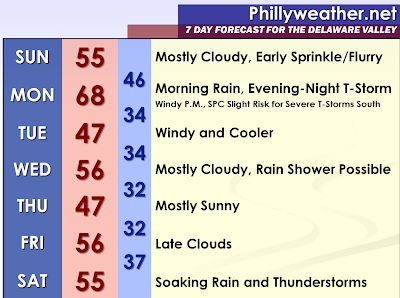

A clipper system will pass to our north tonight. The computer models are not indicating any measurable precipitation across the region. It will be a mostly cloudy night and it will remain fairly cloudy on Sunday Morning. There could be some scattered snow flurries or sprinkles. A steady snow shower may develop across the Poconos and move into Northwestern New Jersey. Otherwise, temperatures will respond to a more west-southwest flow and I expect some areas to rise into the fifties.
On Sunday Night and Monday Morning, a warm front will lift through the region. Rain will develop and possibly a thunderstorm. Initially, some sleet or freezing rain will occur in Carbon, Monroe, and Sussex [NJ] Counties. The warm front will clear much of the region and more than half of the region will enter the warm sector. While the southern areas will be more entrenched, meaning warmer temperatures, I think everyone in the immediate Philadelphia area has an opportunity to rise into the sixties if the clouds and rain clear by the afternoon hours. Some of the southern counties could even rise to around seventy degrees. Meanwhile, northern areas could be stuck in the forties with periods of rain and possibly some good downpours.
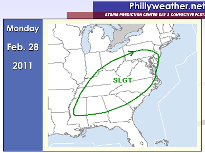
The winds could really mix to the surface with the sunshine ahead of a strong evening and nighttime cold front. However, the highest winds may be reserved with a potential line of thunderstorms that will move in from the west during the evening and then again another round of gusty winds with the cold front itself. This could be more of a convective wind event, but wind advisory to high wind warning winds cannot be ruled out prior to and after the frontal passage. The wind threat can be more closely looked at on Sunday. The Storm Prediction Center has highlighted the southern half of the region in a slight risk designation for severe weather in their day three convective outlook. I would say that is fairly significant for our region during this time of the year. The night arrival of possible convection could be a limiting factor as instability could wane to some degree especially during the last few hours of a winter month. Some of our wind events have done pretty well despite it being night, so I think at least a low probability is warranted. The North American Model makes me wonder if the first few hours of March will come in like a lion. Overall, I think the 12z NAM is placing the convection and moisture in a more logical form than the 12z GFS, but the NAM is a bit too slow on timing.
There could be a cold front dragged across our region on Wednesday. This may be increase the clouds and perhaps lead to a rain shower.
The next significant storm would most likely be during a timeframe of March 4 and March 8. The 06z and 12z GFS Model hints at a pretty fairly decent precipitation event with a lot of liquid to work with. The North Atlantic Oscillation appears to be at least dipping a bit south during this time period and therefore something could be brewing. March 12 and 13 of last year is when we saw a complete pattern change and reversal towards above average temperatures and drier than normal conditions. The pattern change was marked with an historic wind storm and flood during those two days.
Tidak ada komentar:
Posting Komentar