With the latest surge of chill pushing south, combined with a fast moving flow in the upper atmosphere, and the threat for the Thursday storm that was "on paper" a few days ago is trending away from us and is getting squashed by a broad based trough that will set up in the East. The storm is "there" on guidance but the broad trough will prevent it from lifting north up the East Coast.
The upcoming pattern after tonight's rain/snow event suggests cold weather through Friday, with daytime highs in the lower 30's on Wednesday, near 30 on Thursday, and in the mid 30's on Friday. Several degrees below normal and the last blast of cold before the pattern eases starting this weekend.
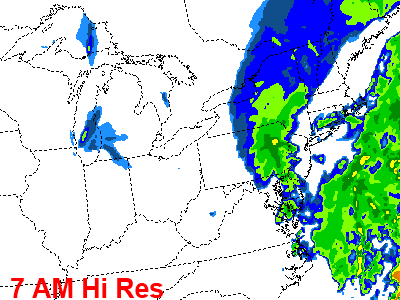
Speaking of tonight's rain/snow event, computer guidance suggests the brunt of tonight's event will come after midnight. Rain is falling as close as York at 6 PM but most of the returns on radar, at this point, aren't reaching the ground in Eastern PA. That should change later tonight as the cold front works east and interacts with the coastal system that will miss us wide right. As the front works east, precipitation will work through -- initially as rain and then transitioning to snow in the Lehigh Valley and Poconos. The Poconos could pick up a couple of inches of snow overnight, with coating accumulations possible as close as Reading and Quakertown. Rain showers could end briefly as snow in Philly tomorrow morning but accumulations in the city are not likely. Most of the precipitation should be out of the region by 9 AM although a few lingering snow showers could move through during Tuesday afternoon.
Senin, 07 Februari 2011
Langganan:
Posting Komentar (Atom)


Tidak ada komentar:
Posting Komentar