Kamis, 28 April 2011
Thursday's Severe Weather Primer
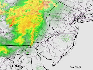
Update, 7 AM: Storms have developed on the southern flank of the Central PA line and are sweeping towards the Philly region at this hour. Storm line extends from near Allentown south into extreme Northern Delaware and is moving northeast at 70 mph. This storm line has the potential to drop winds to over 60 mph due to its fast forward motion and the dynamic wind energy aloft and has resulted in severe thunderstorm warnings being issued for the northern and western suburbs. This warning is out until 8 AM. Rest of our initial post is below.
Today is shaping up as a rather active weather day on paper as the warmth and summery weather come to a halt thanks to a cold front's eastward march into the region. A line of rather nasty thunderstorms is setting up to our west, with severe thunderstorm warnings all along the line from Scranton down into Maryland, with the line slowly lifting northeast as the front is back in Western PA, slowly pressing east. This line will take a couple of hours to approach, and several hours to cross the region. Given the current timing and pace on radar, thunderstorms should work into the city towards mid morning and then clear the city during the mid or perhaps later afternoon. The thunderstorms you see on radar in Central Pennsylvania will not be the ones that hit us -- our activity is back in Virginia since these storms are lifting northeast. The Central PA storms will work through the Poconos over the next few hours, with the Virginia and Maryland activity moving in later on this morning.
With a line of nasty thunderstorms to the west and the atmosphere rather tropical, there is a threat for severe weather and the region is under a slight risk for severe thunderstorms through the day -- mainly with the Central Pennsylvania line this morning and then with the activity in Virginia as that approaches Philly later this morning and around midday. Thunderstorms have the potential to produce damaging winds, isolated tornadoes, and heavy rains. Flash flooding is a threat, mainly north of the city due to the damp soil conditions north of town, but the usual suspect streams and roadways that flood at a drop of a hat around here could have some issues later on if storms are strong enough.
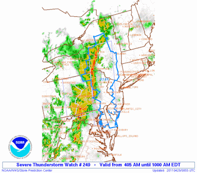
A severe thunderstorm watch is out until 10 AM for the Philadelphia region and points west, north, and south. It wouldn't surprise me to see the watch reissued later on this morning, perhaps as a tornado watch depending on how nasty the Virginia and Maryland activity get over the next several hours (they are under a tornado watch until 8 AM).
Langganan:
Posting Komentar (Atom)


Tidak ada komentar:
Posting Komentar