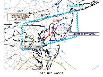
Update 5:55 p.m.: Watching the severe t-storm cluster moving into Delaware...especially Kent County through 6:45 p.m. or 7...this storm has a history of wind damage and large hail. It even prompted a tornado warning earlier this aftn in MD.

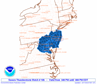
A severe thunderstorm watch has been issued until 9:00 p.m. for the following counties:
In Pennsylvania: Delaware, Philadelphia, Bucks, Montgomery, York, Lancaster, Chester.
In New Jersey: Atlantic, Burlington, Camden, Cape May, Cumberland, Gloucester, Salem, Ocean, Monmouth, Mercer, and Middlesex.
In Delaware: New Castle, Kent, and Sussex.
A severe thunderstorm watch means conditions are favorable for the development of severe weather including large hail and damaging winds. Severe thunderstorms can sometimes produce tornadoes with little or no warning.
Probability of 2 or more tornadoes : 20% or low
Probability of 1 or more strong (F2-F5) tornadoes: 5% or low
Probability of 10 or more severe wind events: 30% or moderate
Probability of 1 or more wind events > 65 knots: 30% or moderate
Probability of 10 or more severe hail events: 20% or low
Probability of 1 or more hailstones > 2 inches:<5% or low
Probability of 6 or more combined severe hail/wind events: 70% or high
The current surface analysis currently shows CAPE values of 1,000 j/g to 1,500 j/kg across much of Central and Southern New Jersey. Low-level lapse rates are around 8 c/km right now which is pretty steep. The lifted index values currently are in a range of -3 to -5. The supercell composite is suggesting values of 0.50 to 2 region wide. The significant hail composite is showing values of 0.50 to 1.50 across Southwestern New Jersey which the Derecho Composite showing values of 1 to 4.
What this all basically means is that there appears to be sufficient instability for thunderstorms to turn rapidly turn severe should there be any forcing mechanism to initiate them. What I think could do the trick is an area of thunderstorms that is beginning to redevelop over Maryland and Virginia. This could cause some very late afternoon and especially early evening scattered thunderstorms to form. These thunderstorms have the potential to form as line segments and supercells.
Most of the region has warmed well beyond the model guidance this afternoon with high temperatures so far in the 82 to 84 degree range. A localized sea breeze front may cool things down in portions of the coastal counties, but elsewhere it should remain quite warm and unstable until the sun begins to set this evening. The sea breeze front itself may serve as a focus for thunderstorm initiation if it begins to interact with the convection that should develop and transpire to our southwest.
Tidak ada komentar:
Posting Komentar