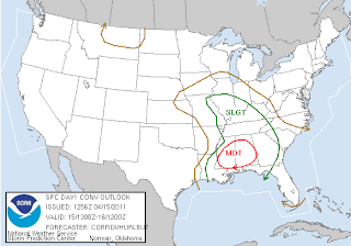
A moderate risk of severe weather remains in place for much of MS and AL. I believe what we will see happen is the line of storms running from MS into northern AL will likely stall out, or at least nearly stall out. Then, I anticipate new storms firing in MS this afternoon and spreading into AL with time. The areas that are under the line of storms when it stalls could wind up with an extended period of severe storms rolling through.
For the Carolinas, the showers spread in tonight, and by late tonight, some storms could get involved. However, our greatest threat of severe storms will likely come after daybreak tomorrow, and possibly more toward lunch time.
I believe damaging winds will be the primary threat, but there are enough dynamics in place that an isolated tornado or two is also possible.
I also should mention that the mountains and foothills could see some widespread 2" type of rains, depending on how things set up.
Tidak ada komentar:
Posting Komentar