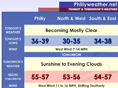

As a disturbance continues to progress southeast of our region tonight, the clouds should diminish and so should the related shower activity. Skies should become clear in areas still be affected by some clouds.
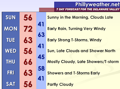
I am confident that Sunday will be the sunniest day of the next three days, especially in the morning hours. By Sunday Evening, clouds will be developing in response to an approaching warm front.
I am still expecting a warm front to produce rain early on Monday and possibly some thunderstorms. If the warm front and associated clouds clears the region by the afternoon hours, temperatures could soar once the sunshine comes out. Towns and cities south of Philadelphia may rise well into the seventies with peaks of afternoon sunshine. Meanwhile, areas well north of the city may see ongoing showers linger and extensive clouds limiting the amount of warmth.
As the warm front lifts northward, a strong and potent low will rapidly deepen across Canada. The low will cause a very strong pressure gradient to develop. Isobars are indicated to be really tight on the map later Monday into Tuesday which is indicative of strong winds forming aloft. As the sunshine develops south of our region and likely reaches at least the Philadelphia area when the warm front clears, mixing will take place which has the capability of bringing down the winds to the surface. Therefore, it could be quite windy from the southerly direction out and ahead of the front. Advisory type winds which can bring down some tree branches are not out of the question. Southern areas which may see less rain, if much at all, may have increased fire danger…although there should be some moisture surging from the gulf. While the wind could diminish some with the setting of the sun, the cold front will begin to approach by nightfall and the wind could be maintained by the strong push ahead of the front into Tuesday Morning.
The other concern is a probable line of convection ahead of the cold front late Monday Night into Tuesday Morning. The model guidance indicates thunderstorms and heavy showers preceding the front. The front will be driven by the potent energy source to our north in Canada. With high shear and strong winds aloft, some severe thunderstorms are a strong likelihood at this point. I did notice the 18z guidance weaker and showing a more serious outbreak for our friends around Pittsburgh. A more widespread severe weather outbreak in our region will hopefully be precluded by the nighttime arrival with waning instability during nightfall.
Tidak ada komentar:
Posting Komentar