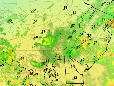
Flood Watches were nudged northward this morning in response to rains that fell across Berks County yesterday, saturating the soil across the far western parts of the area. Today marks a day of more widespread bands of showers and thunder pivoting in off of the Atlantic, brought to you by an upper level low that's in no hurry to move and is pulling a significant plume of moisture in off of the Atlantic.
Radar this morning is showing the soggy rainfall pivoting in from the Atlantic, with temperatures in the 50's north of Philadelphia and in the 60's from Philadelphia on south. The temperature climb today will be modest -- with 50's holding in some spots north of the city while Philly and south should get into the mid and upper 60's before day's end. Rain will not occur at all times of the day and will be more showery in nature -- but when it does rain the potential exists for it to be rather heavy at times in spots. This leads to the potential of localized flooding of streams and roads.
Rainfall over the next two days could exceed three inches in some spots, with everyone in the running to get at least an inch of rain. Again, it won't rain all of the time but it will rain more often than not today and a fair portion of the day on Wednesday.
More: Current Weather
Selasa, 17 Mei 2011
Licensed to Soak
Langganan:
Posting Komentar (Atom)


Tidak ada komentar:
Posting Komentar