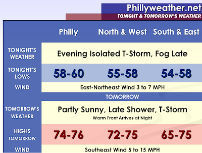

Mainly scattered showers, but some isolated thunderstorms will impact our region into this evening. We may see some sprouting of new showers as the showers from Northwestern New Jersey move southward and begin to interact with a sea breeze frontal boundary. Many places will be dry, but some places could get a quick one-quarter to one-half inch of rain in localized areas. The lightning activity has not been the greatest so far, but perhaps a few of these showers coming in from Northern New Jersey and the Lehigh Valley could eventually turn into a thunderstorm with some discharge. Some of the more intense showers could produce a brief period of gusty winds. Areas that get into the cold section of the front could see stratus develop, breezy east winds, and cooling temperatures into the fifties. Fog will be especially likely where thunderstorms or showers leave moisture on the ground.
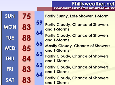
The daytime hours of Sunday at this point look to be partly cloudy. We will be in a lull as our next system arrives on Sunday Night and Monday. The next system will be a warm front. Various models are handling the warm frontal passage differently. Some are very aggressive with the warm front and lift it north rapidly through the forecast area. Others are sluggish with the passage. This has huge implications on the temperature, cloud cover, and amount of precipitation for any given six hour period. At this point, a chance of showers and thunderstorms will be maintained in the forecast. Warm fronts can become more active at night, if the arrival of warm air advection is nocturnal.
Multiple pieces of energy may develop on the warm front on Monday, this as a cold front begins to approach our area from the west. With the warm frontal timing in question right now, it leaves questions about any cold front convection activity on Monday Afternoon and Evening. If the warm front clears our region, the door would be wide open for sunshine to return and cause us to bake…which would cause surface based CAPE and low and mid-level lapse rates to soar to unstable levels. The models showing a rapid northward movement of the warm front (I am leaning towards this solution) suggest cold frontal effects arriving by late afternoon and early in the evening, especially North and West of Philadelphia. If this scenario plays out, some severe thunderstorm development would be a possibility. With these areas impacted with heavy rainfall during the last seven days and another chance for heavy thunderstorms, some flash flooding and flooding would also be a possibility.
We are going to be put right into the center of an active storm track ahead of this sluggish cold front (which eventually stalls over us or right to our immediate south)Tuesday through Friday. Waves of low pressure/spokes of energy will impact our region and combine with the daytime heating of each afternoon to produce thunderstorms and showers. With temperatures expected to rise into the eighties (at least for the areas that remain ahead of the front) and sunshine prior to cumulous and cumulonimbus cloud development, instability will allow surface based CAPE to increase and lapse rates to increase at both low and mid-levels. This suggests at least widely scattered strong to severe thunderstorms each afternoon and evening. More focused and widespread activity will center around forcing mechanisms that are able to provide decent lift and determining these will be the day before or day of the event. Some afternoons could turn out to be decent, while others could be stormy.
With good moisture content in the air and perhaps some slow movement of the thunderstorms, some flash flooding will remain a strong possibility. Now with the previous rains, the ground is much more susceptible to flooding and flash flooding.
Tidak ada komentar:
Posting Komentar