Warmth and humidity will be a common theme in our weather over the next several days as the first signs of a summery heat ridge build into the Mid Atlantic starting tomorrow. The weak frontal boundary that crossed through last night with little more than a whimper is fizzling and warmth will push northward in advance of a storm system that will itself fizzle on Saturday as it finally crosses the region. That storm system, however, will throw a thunder threat into the region for Friday as the front gets close enough to the region to trigger thunderstorms. This system is the same one responsible for the nasty severe weather outbreak on Tuesday in the Plains.
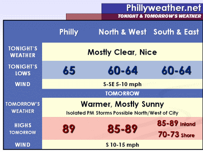
Tonight should be mostly clear and comfortable with lows generally between 60 and 65 across the region. Expect Thursday to be warmer than today, more humid as well, with highs generally in the mid and upper 80's, with the Shore in the lower 70's thanks to southerly winds at 10-15 mph. There could be a few thunderstorms late in the day far to our west and northwest (Central Pennsylvania) as the front nudges towards the region but the city and immediate area should stay dry and mostly sunny.
We'll talk about the Memorial Day weekend weather in a post later on this evening.
Rabu, 25 Mei 2011
Langganan:
Posting Komentar (Atom)


Tidak ada komentar:
Posting Komentar