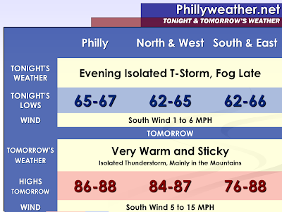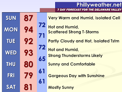

Outside of a very isolated thunderstorm, Sunday is looking like a very warm and humid day. Temperatures should rise well into the eighties. Some of the most robust modeling shows portions of the urbanized areas in the interior flirting with 90 degrees. Morning fog will burn off and the sunshine will come out mixed with cumulus clouds in the afternoon and early evening. Fog may return Sunday Night, late before burning off Monday Morning.
A cold front is expected to approach the region on Monday Afternoon and Monday Evening. The latest model guidance has suggested more in the way of thunderstorms with this system as it moves through the region from the Lehigh Valley to the coastline. Strong surface heating and high dew points should lead to impressive surface based CAPE and steep lapse rates. Temperatures could rise into the lower nineties with some locations having the chance to reach as high as 95 degrees. Scattered thunderstorms are possible with the potential for some to become severe with damaging winds and large hail on Monday; which is also Memorial Day. With outdoor barbeques and other events, the timing of the thunderstorms is of concern. The NAM is a bit more bullish than the rest of the guidance, but has handled the convection well lately.
Heat index values on Monday will easily be in the 95 to 100 degree range. Some of the urbanized sections of the interior have the potential to have a few hours of heat index values of 100 degrees or greater.
The other thing I will be watching is the spike in electricity usage due to the hot temperatures, especially at the shore. For the past several days the shore has been consistently cooler than the interior with a southeast wind. This wind will shift more southwest on Monday, probably ending the break from the heat along the coastal communities. Like some of our big summertime holidays at the shore last year, the combination of more people than usual down at the coast for the holiday period (resulting in high usage) and heat resulted in some localized blackouts.
On Tuesday, it will be another hot and humid day. Temperatures could be slightly cooler behind the weak front from Monday. 90 to 93 degrees sounds reasonable at this point. Another pop-up thunderstorm is possible, but there will not be a real focus on Tuesday across most of our region. North and West of Philadelphia probably will be closest to the cold front moving in from the west for Wednesday.
On Wednesday, this is when we could see some pretty intense and nasty thunderstorms. A strong cold front will approach the region on Wednesday Afternoon and Wednesday Evening. The front will bring an end to the hot and humid weather conditions with significantly less humid and cooler conditions waiting behind the boundary. While not all the time, thunderstorms usually breakout when such heat busts occur. The model guidance does hint at a weak wave forming along the front as it moves through with some pretty good areal coverage of thunderstorm activity. For our forecast…showers and thunderstorms are likely and some could be severe. A good section of the region is under a risk for severe weather in the Day 5 severe weather outlook by the Storm Prediction Center. There are no slight, moderate, or high risk categories in the extended severe weather outlook.
Tidak ada komentar:
Posting Komentar