The complex of thunderstorms that we talked about last night aiming for northern parts of our region took a trip down across the Lehigh Valley early this morning and are working through Central and North Jersey, plus visiting Bucks County at this hour. They are in association with a weak atmospheric disturbance traveling around the heat ridge in the atmosphere, with the storms poised to continue their movement to the southeast over the next hour and eventually off of the coast. For those north of I-195 and even into Burlington and Southern Ocean County in Jersey, thunder will be a part of the early morning.
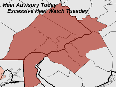
Everyone will get into the heat, except right at the Shore, later on today as these storms push on through and sunshine returns in the next few hours. High temperatures should climb into the lower 90's for many locations, with temperatures near 80 at the Shore. Combine those temperatures with dewpoints in the 60's and heat index values will be close to 95 later on today. Heat Advisories are out for today for the Philadelphia metro, with an Excessive Heat Watch out for Tuesday as we *could* see hotter temperatures tomorrow.
Some isolated pop up thunder can't be ruled out later on this afternoon but the odds of that occurring have decreased a fair bit thanks to this morning's line of thunderstorms crossing the northern and eastern parts of the area providing some stabilization to the atmosphere.
Senin, 30 Mei 2011
Langganan:
Posting Komentar (Atom)


Tidak ada komentar:
Posting Komentar