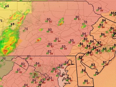
Update, 4 PM: Heat and humidity abound around town as many of us get away for Memorial Day weekend, with a severe thunderstorm watch out to our west. Radar at this point is showing thunderstorms starting to light up with thunderstorms south and west of State College, with scattered storms across Central Pennsylvania's higher hills. Storms, like yesterday, will move northeast over the coming hours. One area of thunderstorm activity that may work its way into parts of the region late this evening is currently over Virginia and lifting north-northeast along the slow-moving (and weakening) frontal boundary. Some of that activity, in a weakened state, might get into parts of Central Pennsylvania and perhaps the far western burbs after 10 PM. Temperatures across the region this afternoon range from 82-88, with heat index values a few degrees higher as humidity levels are not quite as high as they were yesterday.

Includes Berks, Lehigh, Northampton, Carbon, Monroe, and Lancaster Counties in our area. Damaging winds and large hail are the primary threats, although an isolated supercell could produce rotation and allow a brief tornado to develop. Expect scattered thunderstorms to initiate shortly. Some 2" diameter hail cannot be ruled out.
There is about a 20 to 30 percent chance of a severe thunderstorm, isolated in nature, forming to the east of the watch. The majority of activity will be closer to the stalled cold front and therefore, we should not see widespread storms in the eastern areas.
Probability of 2 or more tornadoes: Low (20%)
Probability of 1 or more strong (F2-F5) tornadoes: Low (5%)
Probability of 10 or more severe wind events: High (70%)
Probability of 1 or more wind events > 65 knots: Mod (30%)
Probability of 10 or more severe hail events: Mod (50%)
Probability of 1 or more hailstones > 2 inches: Low (20%)
Probability of 6 or more combined severe hail/wind events :High (90%)
Surface based CAPE Values range from 1,500 J/kg to 3,000 J/kg across our region. Derecho composite values are 3 to 4. Downdraft CAPE is 900 j/kg to 1,200 J/kg. Low level lapse rates of 7.5 and mid level lapse rates of 5 to 7.5 are quite steep suggesting large hail is likely in addition to damaging winds. All and all...where a thunderstorm can fire..it has plenty of opportunity to attain severe limits anywhere in the region, even outside the watch.

Tidak ada komentar:
Posting Komentar