These are the types of days I love forecasting -- not just because the weather is nice, temperatures near ideal, and the sunshine is plentiful, but because it's an easy call to make. The only question now is when the next round of showers and storms will start -- whether it'll be Saturday or Sunday. Guidance is leaning towards scattered storms on Saturday at this point -- generally in Pennsylvania, with Sunday into Monday featuring the best chances for widespread thunderstorm activity. We'll talk more about that later on this evening. Until then, we'll get nice weather...and I hope you all enjoy it.
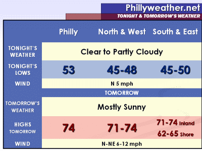
After a nice, but cool night with lows in the 40's and low 50's tonight, we'll see temperatures jump back up tomorrow under plenty of sunshine. Highs tomorrow will again be in the 70's inland, 60's at the Shore, with light north and northeast winds at 6-12 mph.
We'll add a couple of more degrees on Thursday and Friday as the upper low meanders a bit farther east and we lose some of the minor onshore wind influence, with sunshine continuing to be plentiful on Thursday and then starting to wane late on Friday as the first fingers of the storm system for the weekend move in.
Selasa, 10 Mei 2011
Langganan:
Posting Komentar (Atom)


Tidak ada komentar:
Posting Komentar