Radar at 5 PM is showing the heavy rains on their way into the region, with heavy rain falling across Central Pennsylvania down into Maryland, along with a line of heavy rain and thunderstorms extending from Virginia down south into the Carolinas. The line of heavy rain and thunder is lifting north-northeast as the cold front (which is the line of storms) is moving in slowly. This rainfall will work in later on tonight, likely after 9 or 10 PM for folks to the west to after Midnight east of the city. This line of rain and thunder will be heavy, perhaps torrential in spots as it moves through and an inch of rain could fall in the burst as the front moves through later tonight.
Rainfall so far today has varied a fair bit -- a half inch has fallen at the Airport, 0.16" in Atlantic City, to over an inch in Allentown and Reading. The thinking was that areas east of the city would see less rainfall, especially today, than the rest of the region and so far that has verified as the lion's share of rain for I-95 and east will come with that line of thunderstorms tonight and early Friday morning.
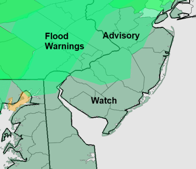
I would expect the flood warning and advisory situation to change through the night as the heavier rainfall lifts into the region. As of now, Flood Warnings are out for Eastern and Southeastern Pennsylvania except for Philadelphia and Lower Bucks County, where a Flood Advisory is out in addition to much of South Jersey. At the Shore, a flood watch remains out but no warnings as of yet as rainfall totals have been much more modest.
Rainfall should be its heaviest tonight between 10 and 1 around Philadelphia, between 1 and 4 along the coast. Flash Flood Warnings are certainly possible and those two to three inch totals are certainly possible, especially in Pennsylvania, before we're all done.
More: Current Weather Page
Kamis, 10 Maret 2011
Langganan:
Posting Komentar (Atom)


Tidak ada komentar:
Posting Komentar