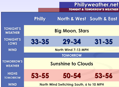

A big moon out there tonight. The moon has not grown in size, but the position of the Earth to the moon will allow for the largest viewing close up since about 18 years ago. It should be clear sailing to view it and take some photographs across our region. The sunshine will be abundant early on Sunday, followed by increase clouds as the sun sets in the evening.
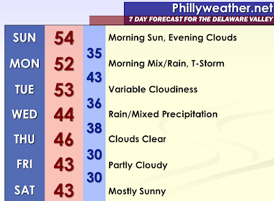
A warm front will approach the region late Sunday Night and on Monday Morning. A round of rain is anticipated with the warm front pushing across the region. There could even be a few scattered thunderstorms since warm fronts love to become more active at night. Some cold air aloft could allow for some sleet or even hail to occur with the thunderstorms or really any of the heavier showers that can transport this colder air to the surface. Across the Poconos and Lehigh Valley, some wet snow could mix with the rain or even change to wet snow for a time should the precipitation be heavy enough to drag below freezing temperatures down through the entire column. For now, I will watch with caution the NAM model which would show some pretty decent accumulations of snow and sleet in Northern New Jersey and Northeastern Pennsylvania with some light accumulation the next tier south of these points. With a high temperature of 68 degrees yesterday in Mount Pocono, even the ground up to the north is quite warm and would at least initially melt the snow, let alone the with borderline temperatures. Of course, we have had a few events since 2006 proving that it can be near 70 one day and snowing with measurable amounts a few days later. Yes, there has been accumulating snow even into the month of April so while it is unlikely the more and more into spring we get, it is not impossible.
The warm front may have some difficulty exiting our northern forecast area on Monday; especially should there be some snow that falls. Meanwhile, the clouds may break leading to a temperature surge in Southern New Jersey, Southeastern Pennsylvania, and Delaware. If this happens, some instability could develop quickly and temperatures will respond upward to the increased sunshine. As a cold front approaches later on Monday, some scattered showers and thunderstorms may develop. The sunshine could also cause a decent breeze to develop at the surface. Quite a contrast may develop between Mount Pocono and Georgetown. Behind the cold front, it will take some time for the colder air to settle into place.
The cold front will stall south of our region and become a train track for waves of low pressure to develop along the boundary. If the front moves far enough south, but yet not too far south to cause drier air to hold in place suppressing the moisture, we could have precipitation combine with air just cold enough for frozen precipitation. With the system so far out, more than a mention of mixed precipitation wouldn’t do the situation any justice.
Canadian high pressure on Thursday and Friday will make it feel quite chilly in our region. With some leaves and flowers fooled by the recent warm spell, frost and freezes Thursday Night and Friday may pose some trouble. I am not sure if the growing season has officially begun to many, but the frost and freeze is worth a mention to some interested parties.
Here at phillyweather.net, we will have continuing coverage of the potential accumulations of snow/sleet in at least our northern half of the region both Monday Morning and on Wednesday.
Tidak ada komentar:
Posting Komentar