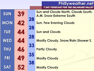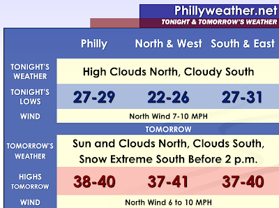

The well-advertised southern storm system, being surprised by a strong Greenland block of high pressure centered in Canada, will pass south of region on Sunday Morning. Besides additional clouds in the southern portion of our region, the affects will not be too large. In fact, Sunday could have glimpses of sunshine in the northern half of the region. Some clearing could even begin in the southern portions of our region during the late afternoon hours with some sun possible before sunset.
Sussex County, Delaware has been placed under a winter weather advisory. The latest North American Model from 18z just coming in is showing accumulating snow with a sharp cutoff in the measurable snow right along the Delaware and Maryland state lines. However, given that there is a chance of a northward jog and it being so close, there is the chance measurable snow makes it into Sussex County. A line from Kent County to Cape May County may deal with some snow showers that could put down a scattered coating according to the NAM. It is interesting that the latest North American Model would have the potential for a narrow strip of a snowstorm around the southern Delmarva in Maryland. This narrow corridor would miss the southern portions of Delaware by about 40 miles or less. The narrowness of the corridor is because of the lack of moisture to the north and the warmer temperatures to the south. Someone could hit the jackpot early Sunday down in the Delmarva if all the cards fall in the right place. Meanwhile, the GFS doesn’t hint at this narrow band, but it shows measurable snow even making into Kent County. So, the extended graphic and near term graphic will make mention to clouds south, snow far south, and glimpses of sun north for Sunday. The cloudy and overcast areas may see temperatures only as high as 38 or 39 degrees and the northern areas (without the snow cover) could actually be warmer.
Monday and Tuesday appear to be looking colder and colder with the Canadian high pressure region maintaining a firm grip on the region. Therefore, I have lowered the temperatures from the previous forecast.
This takes us to Wednesday now which appears to also be colder. The long range models, particular the Global Forecast System run from 12z show the strong block trying to maintain a presence over the region. If this was the case, the moisture will be suppressed further south and air could very well be cold enough for at least mixed showers, if not all snow showers. The latest GFS would have little precipitation north a period of precipitation south. Once again, this forecast is colder than the previous one. The 18z NAM is faster with this energy and so far south that not a person in our area catches a flake. It appears this system is looking less and less ominous for our region. The Southeastern United States will potentially be active with severe weather outbreaks and flash floods.
Tidak ada komentar:
Posting Komentar