Jumat, 22 Juli 2011

Doing Our Part To Keep You Cool


From youtube, a video that shows the sights and sounds of the January 2011 thundersnowstorm in Philadelphia. On a hot day in the Delaware Valley, there's nothing that's probably more appropriate or needed than watching footage of snow in the city in January.   The video below incorporates music into its montage of snow falling on Morrell Park during the same storm.


We're doing our part to help you stay cool on one of hottest days of the year -- we hope you can continue to think cool thoughts over the next few days before the heat eases...it eventually will...and by January we can reverse the trend and run a stream of warm videos as a way to warm up on a cold day.

July 23rd and 24th, 2011 Forecast

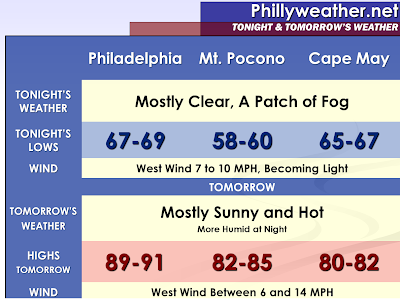
Tonight: This morning's low was only 82 degrees in Philadelphia, and I think Saturday morning will be even warmer than that. It will be very warm, sticky, and stuffy tonight with a low around 83 degrees in Philadelphia. There will be some haze around, and patchy fog will form after 3 AM. Winds will be out of the west-southwest at 5 to 10 mph. The sunset tonight is at 8:24 PM.

Saturday: There may be some leftover patchy fog before 9 AM, then just expect hazy sunshine for the remainder of the day. Very hot and humid with a high near 98 degrees in Philadelphia. The heat index will make it feel like it is between 104 and 110 degrees, almost as bad as today where the heat index could max out as high as 114 with dew points in the mid-70s. Winds will be out of the west-northwest at 5 to 15 mph, with that slight northwesterly flow preventing us from reaching the 100 degree mark. The record high for Saturday is 99 degrees, set back in 1991, and this number will be in jeopardy. There is a 30 percent chance of an evening or nighttime thunderstorm.

Sunday: Hazy sun, hot, and humid. There is a 40 percent chance of thunderstorms popping up in the afternoon. The high will be around 93 degrees with the heat index making it feel like it is close to 100. The record high of 97 degrees, set just last year in 2010, will be safe.

Monday: This 8 day heat wave # 5 should finally come to an end, but heat wave # 6 is right around the corner. More heat is likely for the second half of next week and into next weekend. Monday will feature sun giving way to increasing clouds and a 40 percent chance of scattered thunderstorms. The high will be around 88 degrees.

Saturday Planner

7 AM 83 degrees, Patchy Fog

Noon 94 degrees, Hazy Sun

5 PM High near 98 degrees, Feels Like 104 to 110

Sunrise 5:51 AM
Sunset 8:23 PM

Dangerous heat continues....

Some select highs from yesterday:

Fayetteville: 103
Raleigh: 102
Laurinburg: 101
Wilmington: 100
Burlington: 99
Charlotte: 97
Greensboro: 96


Highs today will head up into the 97-100 degree range for the I-85 corridor and in the 99-104 range when you get closer to I-95, the Sandhills, and the coastal Plain. Heat index values will run from 105-110 for the I-85 areas and over 110 at times farther east.

Overall, the heat continues this weekend with highs staying in the upper side of the 90s and continued muggy conditions.

Isolated storms will be with us today and tomorrow with a little better coverage for Monday and Tuesday.

The heat will slightly back down for the first half of next week, but I still anticipate another wave of heat later next week and the following weekend.

Stay cool!

Kamis, 21 Juli 2011

134 Reasons Why Sticking A Weather Station In A Soy Field Might Not Be A Good Idea

With the recent heat event across the middle of the country, there have been countless stories about heat index values of over 120 degrees. I've mused in twitter about "corn effect" heat index values of 128, 130, or even higher. One of the most aggressive examples of this occurred in Moorhead, MN on Tuesday where the heat index topped out at 134 degrees during the peak heat of the day, thanks to a dew point of 88 combined with temperatures in the mid 90's.

Few probably realize that Moorhead's observation site is in the middle of a farm field ten miles outside of Moorhead proper.   The map below shows the twin cities of Fargo (left of graphic) and Moorhead (where the Google map "A" label is).   Residing about ten miles outside of the city is Moorhead's community airport (a municipal aviation airport such as the ones in Coatesville, Pottstown, Millville, etc.), sitting smack dab in the middle of a field of sugar beets, soy, and perhaps some corn for good measure.   I've been through this area a couple of times in my life -- the area is flat as a pancake, lacking trees, and heavily farmed.

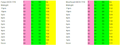
The National Weather Service in Fargo provided a really good write up explaining the factors that lead to some suspicion in the high dew point values -- farming areas where heat index values are substantially higher than surrounding larger towns thanks to the transpiration of crops and wet ground.   Transpiration is the part of the water cycle on the plant side of the fence and essentially is the plant's way to cool itself as it releases water vapor through its cells.  Essentially, think a less stinky form of sweat.   I lifted the temperature comparison between Fargo's airport (a bit farther removed from agricultural influences) and Moorhead's airport data for Tuesday from the NWS in Fargo to show the comparison in data for the two sites.   The peak heat index for Fargo was 116 -- still oppressive -- but the top dew point for Fargo was five degrees lower than the top dew point in Moorhead (83 versus 88), with Fargo's dew point consistently several degrees lower than Moorhead's.


There are countless other examples of "corn effect" heat in these heat waves -- parts of Iowa and other parts of Minnesota had heat index values over 120 thanks to observation sites in the midst or near a farm field.   While some of the dew point values reached in the heat wave in the Midwest were legitimate -- the 82 in Minneapolis is a definite "legit" record since their airport is just about smack dab in the middle of the metropolitan area, the mid and upper 80's dew point values in some of the rural areas are likely enhanced thanks to what may be on someone's dinner plate, feeding trough, or gas tank (ethanol) in a few weeks.   There's no denying the heat or even the humidity in many locations but understanding should be taken when analyzing some of the more extreme data due to location and what surrounds it.

All I can ask is that tomorrow we don't get a dew point in the low 80's with any temperatures over 100...I don't think the region needs a repeat of July 1995 around here.

July 22nd, 2011 Forecast

Tonight: Mostly clear skies. Haze will lead to some patchy fog forming late tonight due to all the moisture in the atmosphere from high dew points in the mid-70s. It will be a very warm and muggy night with lows not likely dropping below 80 degrees in Philadelphia. Winds will be out of the southwest at 5 to 10 mph. The sunset tonight is at 8:25 PM.

Friday: Hazy sun, blazing hot, and humid. The high will approach 100 degrees in Philadelphia with heat index values between 105 and 112. The record high is 100 degrees, set back in 1957, so this record will likely be tied if not broken. There is a 20 percent chance of an isolated thunderstorm in the evening, but most of us will not see this. Winds will be out of the west at 5 to 15 mph, which is ideal for 100 degree weather in our area due to the downslope wind off of the Appalachian Mountains.

Saturday: Hazy sun, very hot, and humid. The high will be near 98 degrees with a heat index between 104 and 110. There is a 20 percent chance of a late-day or evening thunderstorm, but once again most of us will not see this. The record high of 99 degrees, set back in 1991, should be safe.

Sunday: Hazy sun, hot, and humid. The high will be around 94 degrees with a heat index close to 100. There is a 30 percent chance of a pop-up afternoon thunderstorm. The record high of 97 degrees, set just last year in 2010, will be safe.

Friday Planner

7 AM 82 degrees, Hazy Sun

Noon 96 degrees, Humid

5 PM High around 100 degrees, Feels Like 105 to 112

Sunrise 5:51 AM
Sunset 8:24 PM

Heat Ridge About To Pump Temps Up

We're starting the core and prime heat days of our heat wave today, with three days of nastiness ahead where temperatures and dew points combine to make it feel like it's over 100 each afternoon...perhaps even as high as 110 in the prime heat of the day tomorrow afternoon.   Some low clouds, haze, and light fog graze the region this morning as residual less hot air from yesterday lingers while the heat ridge bubbles in from the southwest.   Temperatures are starting out on the toasty side regardless -- generally in the 70's and on the way to topping out well into the 90's by day's end.

Nationally, the main focus of the heat is shifting a bit to the east and southeast from its position of the past few days.   Minnesota and most of the Upper Midwest have seen the passage of a cool front and the introduction of some relief in the temperatures and humidity, with the heat dome shifting to the Ohio Valley and Appalachians for the next few days.  You can see the vast swath of real estate that are under some form of heat advisory, warning, or watch over the next couple of days (inland areas in a red shading) -- effectively close to 2000 miles from Massachusetts to Oklahoma.   Locally, we're under an excessive heat warning through Saturday.

Today's peak heat features heat index values between 102 and 107.   Based on an assumption that we reach high temperatures from 94-97 locally, with dew point values in the low or middle 70's, the heat index below is calculated for a number of different locations based on different combinations.   Even with a lower high temperature, a higher dew point can offset the "cooling" benefit of three degrees and give you an apparent temperature as high, if not higher, than the heat index of a locale with a higher temperature and lower dew point.   That's why it's more critical to know what the heat index is as opposed to simply knowing how high the air temperature is.    All of the air temperatures over the next three days will be hot -- perhaps record breaking in spots -- but the bigger story will be the combination of this heat with dew points that are borderline tropical.   That combination compounds air temperatures in the upper 90's or 100ish and makes it feel like it's a good 5-12 degrees warmer.
Most of us would probably feel better if we were talking about subzero wind chills this morning and not heat index values in the 100's or low 110's!   Regardless, stay cool (or as cool as possible) and drink lots of water.

More:  Current Weather Page

Dangerous Heat...


The heat will be up into the dangerous levels over the next few days. For the I-85 corridor, look for highs in the upper 90s to near 100 today into the weekend. For the I-95 corridor into the Sandhills, highs will exceed 100 in many spots.

When you factor the humidity into the equation, heat index values will exceed 105 at times, and that is dangerous type of heat. Some spots could see heat index values exceeding 110.

Please use lots of caution if you have to be outside for any extended period of time. Take frequent breaks in the air conditioning, and drink plenty of water. Also, please check on anybody that doesn't have air conditioning. Make sure your pets have plenty of fresh, cold water.

A few isolated storms will fire off the next few afternoons, but they will be few and far between. The storm chances look a little better for Sunday and especially Monday.

I still think we get a brief break from the heat Monday and Tuesday, but it sure looks like another big ridge will develop right overhead by the second half of next week, meaning another wave of heat.

Tropics....

Two tropical storms out there.....Bret and Cindy. Both are fish storms and will not impact land.

Rabu, 20 Juli 2011

It's Been Rather Dry Just West Of Us

Despite last night's half inch of rain at the Airport, many areas to the city's north and west missed out on thunderstorm activity and continue to sit in the midst of what is becoming a pretty significant dry spell in South Central through Western Pennsylvania.   Most of last night's heavy thunderstorm activity hit South Jersey, which could also use the rain but has been a bit luckier in the rainfall department this summer than those of us to the northwest of I-95.    Most places locally are running not just weekly deficits in the rainfall bucket...but are now approaching three to four month rainfall deficits.

Just in the last 60 days parts of Chester, Berks, and Lancaster County are running rainfall deficits of over four and a half inches.  Those deficits are also occurring down in Sussex County in Delaware, with deficits as high as six inches to the north of Pittsburgh in Western Pennsylvania.   The region itself needs about an inch of rain per week, give or take, to simply maintain "average" rainfall.   While average typically doesn't happen and rainfall in the summer can easily fall into the feast or famine department, with little separating the two, the lack of rain in parts of our area is starting become a bit of a crop issue.
While we're not technically in a drought in the region, we are entering a pretty prolonged dry spell in parts of the area which is starting to show up in drought reports, particularly for Western Pennsylvania and also Delaware as of last week's drought report.   The newest drought report will come out tomorrow morning, likely expanding some of the abnormally dry zones in Pennsylvania and probably introducing some abnormally dry conditions to parts of our area.  Even in Philadelphia, which has been hit with some significant thunderstorm events since June 1st (June 16th, July 8th, and last night to name three), the Airport's observation site is running over one and a third inches below typical rainfall.

If you're doing a dance to bring on chillier weather, please throw in a rain dance for the region...we could use it!

July 21st, 2011 Forecast

The hothouse of the last few days will become a full fledged sauna over the next three days, with a run at 100 degrees on Friday...perhaps even Saturday...in the Delaware Valley.   The temperature alone is hot but with dewpoints that are poised to be in the 70's more often than not through Saturday we could see heat index values that could reach or perhaps exceed 110 in the worst of the heat on Friday.

Despite the presence of an isolated storm or two in parts of the region this afternoon and evening, most of the region is setting up for a warm, muggy night with low temperatures in the 70's across the whole of the region.   Light winds will add little relief to the mugginess.   Sunshine should dominate on Thursday, with only a few pop up clouds around in the afternoon.   High temperatures should range from 94-98 inland, 83-86 at the immediate Shore thanks to the presence of a south-southwest wind...once you get a couple of miles inland temperatures will be just as hot as we expect to get in Philly.


Eventually the heat will ease -- we promise!   Friday does look to be the worst of the days although Saturday could be just as nasty as heat index values could reach 110 in the worst of conditions.   Thunderstorm chances should increase through the weekend as a weak frontal boundary tries to slip south late Friday into Saturday, holding over the region until a more potent cool front moves through on Monday with a more widespread thunder chance.

Heat and humidity getting oppressive...


Heat and humidity will be our big weather stories through the weekend. Highs today will reach at least the mid 90s in many spots with upper 90s to near 100 degree readings across the region as a whole tomorrow into the weekend. Heat index values today will exceed 100 in many spots with heat indices making a run at 105 or so tomorrow on through the weekend.

A few PM storms are possible today, and then the overall chance of rain in any one spots looks to diminish for tomorrow and Friday before increasing again this weekend.

Stay cool!

Tropics...

Bret continues to behave as expected and is headed out to sea.

The Canadian and European models are trying to sniff out a possible East Coast tropical system later next week....see today's video for the graphics on that.

Selasa, 19 Juli 2011

Excessive Heat Watches & Warnings Up

The prospect of the worst of the season's longest heat wave is coming upon us for late this week, with Excessive Heat Watches and Warnings out for much of the region due to the nasty combination of heat and humidity that is poised to worsen over the latter half of the week.   Excessive Heat Warnings are out for the Delaware Valley for now through at least Thursday, likely extending to Saturday given current trends, with watches out in Central Pennsylvania and in the New York Metro area for later this week.


We all know it's going to be hot, with computer guidance suggesting 100 is certainly within possibility for Friday and upper 90's sandwiching around that for both Thursday and Saturday.   The heat itself is bad enough and on Friday and Saturday, potentially record breaking.  However, the humidity will be the worse impact as dew point values in the lower 70's could yield heat index values upwards of 110 in some parts of town.   The heat/humidity combination is arguably much, much more potent and to be frank, it doesn't matter if anyone is forecasting 100 or not...the heat index will be higher and frankly makes the weather that much worse.


Thursday's records are rather tough to hit but Friday could pose a potential record breaking day, especially in Atlantic City and perhaps Philadelphia.  Saturday's record could be tied in many locations.   Even if we don't break a record, Friday will likely be the season's hottest day in terms of both temperatures and heat index.

Scattered Storms Bringing Some Relief


Apologies for the delay in getting something out there on this afternoon's thunderstorms.    After a scorching high of 96 degrees, some relief hit parts of the region this afternoon as thunderstorms developed...initially across Delaware and then slowly building farther north and west as the afternoon turned into evening.   While not everyone was stormed upon today (my backyard is in a proverbial dust bowl it seems of late), others are under flood advisories after picking up a couple of inches of rain per doppler estimates.

There are no severe thunderstorm warnings out as of 8 PM in the immediate area (there is one until 9 for Southern Chester County and Cecil County in Maryland) -- but there are some heavy thunderstorms still to the south of the city and in the city proper -- all of which are moving slowly southeast.   We should see activity fizzle out in the next couple of hours, leaving a partly to mostly cloudy sky with some patchy fog possible through the region in the overnight hours.

More:   Current Weather Page

Union Gamecast


Everton is in the midst of warming up for the Premier League season (which seemed like it just ended a few weeks ago...some "offseason" for the footballers!) while the Union are taking the week to play a couple of "friendlies" (also known as exhibition games for the non soccer crowd) against a couple of European teams.   Wednesday's match will be at PPL Park and will be played in a proverbial hothouse -- temperatures in the 80's for the match with partly cloudy skies.   There *could* be a storm that pops up in the afternoon tomorrow but odds are leaning against any storms at the match as of this evening.


Union Gamecasts will be updated throughout the course of the season (or at least whenever possible), featuring the forecast for the game at kickoff and in the 90th minute.

July 20th, 2011 Forecast

Tonight: There is a 20 percent chance of an isolated thunderstorm this evening and overnight. Otherwise, expect a stuffy and muggy night under partly cloudy skies. Lows will only drop into the lower to mid-70s overnight. Winds will be light out of the east-southeast. The sunset tonight is at 8:26 PM.

Wednesday: Hot sun and humid. The high will be near 94 degrees in Philadelphia, but the humidity will make it feel like 96 to 101 degrees. The record high of 99 degrees, set back in 1930, will be safe. Southeast winds will shift from the south at 5 to 10 mph.

Thursday: Very hot sun and humid. The high will be around 98 degrees with a heat index between 105 and 110 degrees. This record high of 103 degrees, set back in 1930, should be safe as well.

Friday: Blazing hot sun and humid. The high will easily break 100 degrees, and I am forecasting a high around 102 degrees for the city of Philadelphia. Once again it will feel like 105 to 110 degrees with the humidity. This record high of 100 degrees, set back in 1957, will be broken.

Wednesday Planner

7 AM 78 degrees, Humid

Noon 90 degrees, Hot Sun

5 PM High near 94 degrees, Feels Like 96 to 101

Sunrise 5:49 AM
Sunset 8:25 PM

Our Obligatory Post On Tropical Storm Bret

The Atlantic hurricane season is sorta lurching ahead -- the second storm of 2011 formed on Sunday in the Atlantic basin (Bret) but it's nothing to fear and will stay away from the East Coast as it is nudged northeast in the main upper level flow aloft.


Bret does not look very impressive this morning -- dry air to the north of the storm has been winning the battle against intensification with this storm system and Bret has weakened a fair bit and its presentation on satellite has worsened a good deal since yesterday afternoon.   Bret is working into a less favorable environment for tropical cyclones thanks to that dry air aloft and it would not surprise me if the storm weakened a fair bit further in the coming day or two, perhaps becoming little more than a remnant low by this time Thursday morning as it passes between Bermuda and the US coast (see below).


Bret won't even kick up the surf along the East Coast since it's not a very strong system but it is postworthy (although certainly not noteworthy) because it is not only a tropical storm but a sign that the hurricane season is slowly getting its act together.   We'll probably have a good deal more to talk about in the coming weeks as the Cape Verde systems start their annual trek across the Atlantic.

Heat and humidity arriving....scattered storms too...


Here come the 90s....low to mid 90s for many of us today, then mid to upper 90s right on through the upcoming weekend. Not only will it be pretty hot, it will be muggy as well, and morning lows will only drop into the mid 70s most days.

A disturbance is rolling our way from the Midwest, and that will likely trigger some scattered storms this afternoon and evening. A few storms could produce some damaging winds and/or some hail.

Scattered storms will remain a possibility tomorrow, and then I only expect an isolated coverage Thursday and Friday before the coverage increases again over the weekend.

I still see signs of a break in the heat as we get into next work week.

Bret...

Bret is behaving as expected and has begun a northeast motion, and the system will head between the US East coast and Bermuda. The only real impact Bret will have on the US is some increased surf and rip current potential for the Eastern Seaboard this week.

Senin, 18 Juli 2011

Tonight's Scattering of Thunderstorms

Update, 8:20 PM:   A line of showers is on the radar from Northern New Jersey back into Central Pennsylvania, generally along and north of I-78 at this point.  The cells are moving southeast and were with the line I talked about a couple of hours ago.   They've made a bit of a right turn the last couple of hours and have a shot at grazing some of us later tonight.  The first fringes -- generally just now grazing Allentown -- are weakening somewhat while a stronger line exists north of Scranton.   These storms might make it into Bucks or Trenton...perhaps even Philly later on...but the theme of the evening at this point is scattered storms...some hits, some misses.


Update, 6:15 PM:    You can see radar from State College showing the thundery landscape this evening -- a bit of a training setup taking shape north of Williamsport to near Scranton -- those storms could bring some heavier rains to the Poconos later on this evening if they continue to hold and track east-southeast as they are at present.  Locally, the strongest cell in the Central PA storms near Harrisburg will track far to our west, perhaps scraping Lancaster this evening.   There are some lighter showers and a rumble or two of thunder working into Berks County -- some of that activity could lead to a round or two of drops and maybe a few thunder rumbles in the next couple of hours.


The offshoot of this morning's thunderstorm line in Ontario and Upstate New York has spawned new thunderstorm activity to our northwest and west this afternoon while the main activity that was to our north has fizzled out as the storm line reached the Binghamton area.   Storms extend from Williamsport to near Pittsburgh and are moving southeast.   Given the current trend on radar, most of these storms may pass to our west unless the thunderstorms around Williamsport can build farther east or northeast in the coming hours.


As of right now, there are no watches and only one severe thunderstorm warning with the line (out by Pittsburgh) but the storms will have the potential of intensifying somewhat thanks to a warm, humid airmass in place over the region this afternoon as temperatures are in the 90's out ahead of the line.   The strongest of storms could bring gusty winds, some hail, and localized heavier rains.   As of now, Chester County and perhaps western Berks County could see thunderstorms in about three hours or so...if the line builds farther east we could see activity into the Philly region after 7 PM.

More:   Current Weather Page

July 19th, 2011 Forecast


Scattered thunderstorms are still on track to cross the region this evening and perhaps overnight from north and northwest to south.   Some of the storms have the potential of being severe in spots, with gusty winds and heavy downpours of rainfall in localized areas.   Depending on exact timing, we could see a few thunderstorms linger to the south of the city in the early morning hours tomorrow before they clear the coast.   With a weak frontal boundary lurking nearby, the potential exists for more thunder to pop during the afternoon hours in parts of the region (generally the Philly metro and south and west, close to the location of the frontal boundary).

The weak front will have little impact on temperatures locally tomorrow but may knock humidity down a notch or two to our north.   Highs tomorrow should range from 90 to 93 inland, mid 80's at the Shore with a west to northwest breeze.  We'll stay warm and rather muggy through the night, with low temperatures ranging from 70-75.


Friday continues to shape up as the hottest day of the stretch and yes, 100 is still possible despite our forecast of 99 (for now).   Heat index on Friday will matter more and the potential of a heat index of 110 is certainly within the realm of possibility on Friday afternoon locally.

Updated Thoughts on Severe For Today & Tonight

The Storm Prediction Center has everyone from an Atlantic City-Wilmington line on north under a slight risk for severe weather.   There's a fair bit of uncertainty about how dry we stay locally as guidance varies a fair bit between "storm" and "no storm" locally through today.


This morning, thunderstorms already grace the radar's presence with a complex of thunderstorm activity north of Toronto in Canada, sliding southeast.   These storms will cross New York State this morning into the afternoon hours, perhaps setting up along the NY/PA border by afternoon given their trajectory.   Whether the storms survive through the day or not is not important...this batch of storms or their remnant will be agitated and enhanced by improving dynamics later on, which means odds favor some thunderstorms along the NY/PA border towards mid afternoon, with them sliding south and southeast from there.  

Most computer modeling (GFS, EURO) has us remaining dry through Midnight locally while the NAM shows the line of thunderstorms sneaking into the area late this afternoon and into the evening hours, from north to south and generally after 4/5 PM in the Poconos and after 8 or 9 PM locally in Philadelphia.   While there are some aspects of some of the NAM modeling that are a bit off (the potential for a second complex of storms in one of the NAM's forecasts is a clear outlier to the other modeling and probably not likely), the timing element makes the most sense given location of storms at present and trajectory.

So, summing up all that, expect much of the day to be generally very warm and increasingly humid locally.  We should be thunder free in Philadelphia through dinner but odds favor some storms after 8/9 PM in the city, after 4 PM in the Poconos.   The strongest storms have the potential to drop hail and/or bring gusty winds with them and the "best" chances for the strongest storms will be to our north where instability will be a bit more sufficient for strong and severe thunder.   As always, we'll update the thunder threat later on!

More:   Current Weather Page

Back in the saddle...

Good to be back this morning after a week away from the weather maps.


The big weather story this week in our region will be building levels of heat and humidity. Many highs today and tomorrow creep back up toward the lower 90s, but then it's mid to upper 90s Wednesday through the weekend...even some 100+ reading possible in some spots.

A few afternoon storms will pop up today in the higher elevations, and a couple might drift into the foothills. However, everybody has a much better chance tomorrow of seeing some scattered afternoon and evening storms. Thereafter, it just looks like we will see a few pop-up afternoon storms on a daily basis through the weekend.

There are signs of another break in the heat around here by next Tuesday or Wednesday.

Bret...

Tropical Storm Bret is slowly gaining strength near the Abaco Islands. However, Bret will head out to sea and not impact the US directly. There will be some increased surf and rip currents for the Carolina beaches later this week.

Check out the Tropical Weather page of my site for all of the info you need regarding Bret and the rest of the tropics...

Minggu, 17 Juli 2011

Weather Rewind, July 10-16, 2011

Temperatures last week averaged 2.6 degrees above where we should be for this time of the year -- locally, we had a four day stretch of 90 degree weather come to an end with the passage of a cool front on Tuesday.  It dragged in marginally cooler air from the west that controlled the weather for Wednesday through Saturday as high temperatures for the last four days of the week held in the upper 80's daily.    All in all, the week's weather was docile but rather warm -- typical for the height of summer.

The one thing we're lacking for a bit locally is rainfall.  Despite a solid inch to two inches of rain last week, our dry spell continues locally as rainfall rates over the past two months are running anywhere from 25% (western suburbs) to 60% of normal in much of the Delaware Valley.   Some parts of the Pinelands are doing ok in the rainfall department as are parts of the Poconos and Catskills up north...however, locally we are running pretty dry and could use a nice widespread rainfall event.

Chance of Severe Storms Late Monday

A weak frontal boundary will slide south, buoyed in the atmosphere by a disturbance that will track east along the front and act as a trigger for shower and thunderstorm development in the afternoon hours to our north. With additional heat and humidity in the atmosphere, there will be sufficient instability to fire off at least some thunderstorm activity to our north, and perhaps as well locally. The Storm Prediction Center has Pennsylvania and the northern two-thirds of New Jersey in a slight risk for severe weather on Monday.


The highest odds for severe weather reside over the twin tiers of Pennsylvania and New York -- with a 30% chance for severe weather within 2 miles along and north of I-80 to just north of I-86 in New York.   Most of these storms will fire on the front edges of a decaying MCS that will likely track through the Great Lakes tonight.   This MCS could spawn a line of scattered severe storms after midday that will slide southeast towards us.    Given the timing and likely origin points of thunderstorms, we should be dry for much of Monday and start seeing an increased thunder threat in the Poconos after 3 PM, locally after 6 or 7 PM.


Higher resolution modeling is rather "ho hum" on thunderstorm chances locally -- while other models (GFS, NAM) at least paint a chance for thunderstorms across the region in the evening hours.    This is an instance where the best chances for thunder will reside to our north...and if storms can hold together despite the timing working against us somewhat (evening time) we could get a few stronger rumbles of thunder as well.

We'll have an update on this in the morning.

July 18th, 2011 Forecast

Heat and humidity will be a common denominator in the week's forecast.   Thunderstorms will also play a part in it from time to time, with late tomorrow afternoon into tomorrow night serving as one of those periods of time where thunderstorms will be possible.   A weak cool front will slide south into the region and serve as a focal point for thunderstorm development to our north during the afternoon hours.  The storms should slide south and southeast, towards us for the evening.  We'll have a more thorough post on the thunder threat later on this evening.

Ahead of the weak front resides heat and humidity.  High temperatures tomorrow will range from 91-93 in many locales, with heat index values around 95 or so in the prime heat of the day.  While it looks like child's play compared to the potential heat of late week, it will still feel very warm out.

Tonight's weather features a mix of clouds and stars, with lows ranging from the mid 60's north to low 70's city and Shore.


Week Ahead:   The weak front stalls out nearby and thunder threat extends into Tuesday with some pop up storms possible.   As the much talked about heat ridge extends east into the Appalachians and eventually Mid Atlantic, we'll see temperatures climb in the latter half of the week.   Along with the increased temperatures will be a chance of some thunderstorms in the afternoon on Thursday.  We could also see a complex of thunderstorms travel around the periphery of the heat ridge through the week.  Timing those specific rounds of storms is tough to do so I'll leave those out of the forecast for now but they may need to be nudged in, especially north of the city, later this week.    The hottest days look to be Friday and Saturday at this point, with temperatures in the upper 90's if not 100 degrees on both days.

First Half of Warm July Review


July 2011 has started out a bit like July 2010 -- not as extreme in the heat department but still pretty darn warm.   Temperatures through yesterday were averaging 3.2 degrees above the old averages, 2.3 degrees above the new averages (average temp of 80.4).   We likely won't approach July 2010's standard of heat (81.7) for the month but we will probably see a top ten warmest July on record once all is said and done locally.   Month-to-date, we've had nine days of 90 or warmer in Philadelphia and we'll likely add another half dozen or more in the month's second half as we enter a heat wave this week.

In terms of rainfall, the city and points north/west are generally drier than average.   Philadelphia has picked up 1.51" of rain this month, almost all of it falling on July 8th (that Friday with the heavy thunderstorms).   The only areas that are above average -- much of it thanks to other thunderstorms that popped that week -- are across the Pinelands in New Jersey.   The rest of us are generally pretty dry or very dry, with rainfall rates running near 50% of normal this month.


Sabtu, 16 Juli 2011

Forecast for Sunday, July 17, 2011


The area of high pressure which brought some short-lived relief to hot conditions just a few days ago is now going to become our foe. It will turn into a Bermuda High, pumping in a southwesterly flow of hot and humid air. Sunday, temperatures will rise into the lower nineties with increasing moisture. Heat index values will be in the mid-nineties.

On Monday, widespread mid-nineties are expected. A weak cold front will begin to sag southward into our region. This front should prompt the development of cumulus clouds and scattered thunderstorms later in the afternoon. Plenty of instability will build up and therefore any thunderstorm that can develop has the potential to become severe. The 12z NAM has most of the action (quite intense) coming through after 6 p.m. and lingering with us right through midday Tuesday) with the southern counties spared the worst of the convective line. The Storm Prediction Center has placed much of the region (except the south) under a slight risk designation for severe thunderstorms on Monday in the Day 3 convective outlook. The GFS and EURO vary a bit on the timing of the convection….but the bottom line is a period of potentially active thunderstorms from Monday Afternoon into Tuesday Morning.

The picture for Tuesday is becoming clearer, but with some details still missing. It appears thunderstorms will be ongoing early in the period…perhaps lingering into midday at worst with extensive cloudiness when most wake up. Clearing may not happen until early afternoon in portions of the area. If the NAM is correct, the thunderstorms and convective debris cloud could be with us for so long that temperatures rise only into the upper eighties once the sun reappears…potentially temporarily busting the heat wave. For now, I will go with 90 degrees. Some areas could be dealing with flash flooding if 1 to 2 inches of rain occurs in a short period of time and the NAM is correct about the slow nature of the convective line. During the afternoon, the front will settle into the area and stall out. Depending on how fast we can recover from the morning convection…some additional pop-up thunderstorms may develop along and south of the boundary.

The front will still be in our vicinity on Wednesday, before moving back northward as a warm front on Wednesday Night into Thursday Morning. Temperatures and the dew points during this period will be very dependent on where this boundary settles. The boundary could also act as a trigger for a few isolated thunderstorms which could impact the amount of heating which takes place. At this point, lower nineties still appear attainable across much of the area on Wednesday. If portions of the area end up on the northern side of the front, the humidity levels could be somewhat in check.

By Thursday Afternoon, we will be within the warm sector with a building heat ridge from the Midwest. There are a few issues though that may impact how high we go in the temperature department...keeping the brutal heat potentially at bay. First, will be the amount of rain that could fall on Tuesday. This could soak portions of the region. Wet grounds usually shave off a few degrees in the temperature department. Second, the GFS shows some troughs impacting the area…especially on Friday Morning. If convection is ongoing or develops on Friday…even a few hours of clouds will be enough to prevent a run at 100 degrees. The ridging looks strong though and may eventually end up keeping much of the area out of the “Ring of Fire”.

I have been biting my nails (expression) on inserting a “100” in the graphic this early out…especially with the GFS showing some convective chances. As we often say here on the site, whether it is 98 vs. 100 degrees makes no true difference to the danger that will develop with the excessive heat expected. My choice to go with 100 degrees is that I expect that at least some location in the area that avoids any thunderstorms will make a run for it and strike a home run. We already had some 100-103 degree highs earlier this year in our area (Philadelphia fell short)…and truth be told…on paper Friday looks hotter than the day we had those highs in the 100’s recorded. If the model data is correct about Dew Points in the lower and mid-seventies from Thursday into Saturday…heat index values will range between 105 and 110 degrees. Last year when we did hit 100 and even earlier this year, it was a dry heat. See this is another potential fly in the ointment…studies suggest that we struggle to hit the Century Mark when the air is loaded with moisture.

The all-time high temperature for Philadelphia is 106 degrees.

Already this year, we have seen a few heat related deaths…especially in the urbanized areas where there is low income residences who cannot afford proper cooling devices or who have them…but cannot afford to keep them on. It is in these areas where crime is also high and many then also fail to open their windows to get at least some circulation flowing through the hot infrastructure. The other area we commonly find issues is when careless individuals leave young children inside a closed vehicle. So be careful and here are a few pieces of advice that we pull out from time to time.

Heat exhaustion may develop when fluids and salt that are lost through sweating are not replaced. Primary symptoms include extreme weakness, fatigue, giddiness, nausea or a headache; other symptoms may include clammy or moist skin, a pale or flushed complexion and a slightly higher-than-normal body temperature. Someone experiencing heat exhaustion should rest in a cooler place, with the feet raised and tight clothing loosened, and slowly drink salted liquids. Heat exhaustion may rapidly turn into heat stroke, a potentially fatal condition. If symptoms persist or worsen, seek immediate medical attention. Heat stroke is a serious and potentially fatal condition that requires immediate medical attention. Heat stroke occurs when the body's heat-regulating system breaks down, sweating stops, and body temperature rises significantly.

Signs of heat stroke include:

Mental confusion, delirium, chills, dizziness, loss of consciousness, convulsions or coma , a body temperature of 105 degrees F or higher, Hot, dry skin that may be red, mottled or bluish , and a strong, fast pulse. If you suspect someone is suffering from heat stroke, call an ambulance immediately. Until medical help arrives, move the victim from the heat and into a cool place, soak the victim's clothes with water and use a fan or ice packs.

Close all drapes/blinds on the sunny side of the house.

Remember to drink plenty of fluids, espeically water.

If a family member appears overheated, use cool compresses to cool skin.

Remember to check on elderly or home-bound neighbors.

Spend as much time as you can in cool surroundings. Use fans and air conditioners. During the warmer, daytime hours go to air-conditioned malls, libraries, movie theaters or any public place that is air conditioned if you don't have A/C.


Slow down and take it easy. AVOID Physical activity.

Wear light-weight, light-colored, loose-fitting clothing made of a breathable fabric, such as cotton.

Wear a hat or use an umbrella.

Another reminder is that unusual heat like this can lead to blackouts. Some long lasting outages can cause heat to build up in homes that normally have A/C units.

Transformers can easily fail from overheating. Transformers are built to dissipate their heat, but in extreme weather conditions such as we’re experiencing, there is no ability to cool because temperatures remain high throughout the night (we are forecasting 80 degree lows around 3 a.m. with 82-88 most of the night at the end of the week). Problems are also magnified in the confined spaces of an underground electrical system (which we have in Atlantic City-Trenton-Allentown-Camden-& Philadelphia). If there is a flaw or crack in the cable insulation, a short circuit could occur as the cables expand from the heat. Increased demand for air conditioning means more electricity flowing through power lines. This causes them to heat up and expand or sag, and in some cases they sag into tree branches, causing a short circuit. Electricity loads combined with high temperatures cause transformers to heat up, sometimes reaching critical levels that if uncorrected would permanently damage the equipment. The equipment will automatically and safely shut down to protect itself and other equipment. High current causes stretching of cables, switches and other equipment and can increase the size of minor flaws in insulation or connections. Electric equipment can be weakened by lightning strikes and circuit failures, making it more susceptible to an outage as it can no longer withstand the increased flow of electricity during periods of high demand.

We will be watching a disturbance along the Southeastern United States coast for tropical development. There is a 20% chance of development in the next 48 hours...but a potentially higher chance beyond that time. What impact, if any, this will have remains to be seen...could cause more humidity and perhaps an uptick in pop-up cells sometimes.

Jumat, 15 Juli 2011

Getting A Pumped Up Ridge

Channel your inner Hans and Frans -- Mother Nature is about to pump *clap* up the atmosphere with a ridge of high pressure in the mid atmosphere, resulting in a stretch of rather hot weather late next week or next weekend locally, with a run at 100 degrees not out of the question locally.

Mercifully, we will not see the worst of the heat and humidity.  That honor belongs to the Midwest, where this ridge will set up shop and temperatures could reach or breech 100 degrees in Minneapolis, Chicago, St. Louis, and other cities for a few days next week, with Chicago potentially seeing several days of upper 90's and near 100 degree temperatures.   This heat wave has the look of 1995's long duration heat wave to it...thankfully, it should not last as long but it could be just as nasty for Chicago and for the Midwest and it would not surprise me if there were fatalities in a number of the big cities from the heat.

 The question regarding "how hot we get" comes down to position of the upper ridge over us for Thursday-Saturday.   The GFS in the afternoon runs on Friday centered the ridge over the Appalachians, a pretty good spot for us to get some hot weather as upper levels are rather warm nearby.   The core of the heat ridge is near us and temperatures could approach 100 in such a scenario.  The Euro is a bit farther west with the heat core, over the Ohio Valley on Friday evening, which results in mid 90's for highs...still hot but not "prime heat."    The models have flipped and flopped over which scenario they prefer but in either scenario we're talking mid 90's, at least, for Thursday through Saturday.


If the "cooler" solution were to verify we could see some thunderstorm complexes track closer to the region around the periphery of the heat ridge.   The "ring of fire" of thunderstorm activity around the upper ridge is certainly possible...if the ridge isn't quite as strong or is centered a bit farther west we could see some thunderstorms in/close to the region during the heat event.

Factoring in humidity, heat index values could reach 105 during this time frame.   It will be oppressive but not as bad as in the Midwest, which could see heat index values around 120 on Monday or Tuesday in some locations.   The heat is back on...and this is likely the prime heat event for the year across the country.

July 16th and 17th, 2011 Forecast

 Beautiful weather of the past couple of days will nudge into warmer and eventually more humid weather this weekend.   We probably will approach 90 both days this weekend, perhaps hitting it on Saturday as well as Sunday (we forecast 90 for just Sunday in Philadelphia at this point but 89 on Saturday).   Sunday's 90 could be the first of a several day run of 90+ heat in the Delaware Valley, with a potential major heat event on tap late next week.   Before we get too far ahead of ourselves, let's focus on this weekend's weather.   As high pressure will be in control over the region, skies will be mostly sunny both days with pop up clouds in the heating of the day.    On Sunday, some pop up storms can't be ruled out across Central Pennsylvania as humidity levels and atmospheric instability increase.    A few of those storms could meander into the northern/western burbs very late in the day.  Other than that slight chance of thunder, the weekend is dry for many and temperatures typical of July.

Highs this weekend will be in the upper 80's to near 90 across inland areas, low 80's at the Shore.  Lows range from around 60 in the Lehigh Valley tonight and tomorrow night to the upper 60's/near 70 in the city and at the Shore.  Sunday night will be warmer for all (mid 60's to low 70's) as humidity levels rise.


Coming This Weekend:   We'll update Sunday's forecast and preview what may be a rather hot time of it locally next Thursday-Saturday.

weather


Staying Behind Last Year

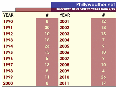
Today marks the halfway point of summer (July 15th) and thankfully, compared to last year, we're not on as blistering of a 90 degree day pace.   Through today, we will have registered "just" 17 days with highs of 90 or higher.  That's nine days behind last year's pace but it is still more than any year between 2003 and 2009.   It's still been a hot summer and the recent run of 90's (nine days so far in July) has helped this year's pace out quite dramatically.   Still though, 2011 is shaping up as a less hot summer to last.

Here on out, the most 90 degree days in the last 20 years belongs to 1995 as they put up 36 days of 90 or above between July 15th and the end of the warm season.  Even on that blistering pace, we would come up short to 2010 in 90 degree days (our total would end up at 53 if we somehow put up '95 type heat from here on out).   Last year featured 29 days of 90 or higher here on out, second most in that time frame.   The average summer since 2001 has had 15.6 more days of 90 or higher -- we would end up with a total of 33 (rounding up) at season's end if we merely held to average 90 degree days here on out.   A year end total in the mid 30's is a pretty realistic bet...40+ 90 degree days this year is a stretch but not out of the realm of possibility.

Kamis, 14 Juli 2011

A Look At The Shore

An irregular feature that we're starting today at Phillyweather.net (and hopefully if we stick to it, it will run during the May-September timeframe going forward) is a look at the ocean locally and how temperatures are faring, any trends that need to be noted, and any "storms" on the horizon that could generate some surfing (dude).  

One of the noticeable trends this week at the coast is a drop in sea surface temperatures along the Jersey coastline.   This happens from time to time during the summer and it's known as upwelling.  You can see the difference in temperatures along the Shore from Monday (first map below) to Thursday (second map below), with the reds and oranges (temperatures that are above 77, 78 degrees in the surface water) replaced by blues and greens (temperatures below 72 and in the case of the blue shading, below 70 degrees).


Upwelling occurs locally when warmer surface water is pushed out to sea and replaced by cooler water that comes up from lower depths of the sea below.  Upwelling can be caused by a strong wind push offshore, such as the one we dealt with on  Monday and Tuesday along the coastline, and can drop temperatures in the immediate ocean along the coast by ten or more degrees in a matter of 12-24 hours.   This can turn what feels like great ocean water one day into an ice box the next.   Delaware Bay can also be victimized to an extent (see above) as water gets pushed out into the Atlantic (typically on northwest winds) and cooler water below the surface replaces the moved out warmth.   However, the Bay is shallower and upwelling does not last as long in the Bay as it does along the coast.

The cool water will not last -- the sun's energy will warm this water back up and ocean temperatures along the coast for the weekend will slowly warm, perhaps not to the upper 70's as we saw a week ago, but back into the low/mid 70's for the weekend.  This will make swimming a bit more tolerable although some local beaches may have an issue or two with cooler temperatures through the weekend.