Jumat, 22 Juli 2011

Doing Our Part To Keep You Cool


From youtube, a video that shows the sights and sounds of the January 2011 thundersnowstorm in Philadelphia. On a hot day in the Delaware Valley, there's nothing that's probably more appropriate or needed than watching footage of snow in the city in January.   The video below incorporates music into its montage of snow falling on Morrell Park during the same storm.


We're doing our part to help you stay cool on one of hottest days of the year -- we hope you can continue to think cool thoughts over the next few days before the heat eases...it eventually will...and by January we can reverse the trend and run a stream of warm videos as a way to warm up on a cold day.

July 23rd and 24th, 2011 Forecast

Tonight: This morning's low was only 82 degrees in Philadelphia, and I think Saturday morning will be even warmer than that. It will be very warm, sticky, and stuffy tonight with a low around 83 degrees in Philadelphia. There will be some haze around, and patchy fog will form after 3 AM. Winds will be out of the west-southwest at 5 to 10 mph. The sunset tonight is at 8:24 PM.

Saturday: There may be some leftover patchy fog before 9 AM, then just expect hazy sunshine for the remainder of the day. Very hot and humid with a high near 98 degrees in Philadelphia. The heat index will make it feel like it is between 104 and 110 degrees, almost as bad as today where the heat index could max out as high as 114 with dew points in the mid-70s. Winds will be out of the west-northwest at 5 to 15 mph, with that slight northwesterly flow preventing us from reaching the 100 degree mark. The record high for Saturday is 99 degrees, set back in 1991, and this number will be in jeopardy. There is a 30 percent chance of an evening or nighttime thunderstorm.

Sunday: Hazy sun, hot, and humid. There is a 40 percent chance of thunderstorms popping up in the afternoon. The high will be around 93 degrees with the heat index making it feel like it is close to 100. The record high of 97 degrees, set just last year in 2010, will be safe.

Monday: This 8 day heat wave # 5 should finally come to an end, but heat wave # 6 is right around the corner. More heat is likely for the second half of next week and into next weekend. Monday will feature sun giving way to increasing clouds and a 40 percent chance of scattered thunderstorms. The high will be around 88 degrees.

Saturday Planner

7 AM 83 degrees, Patchy Fog

Noon 94 degrees, Hazy Sun

5 PM High near 98 degrees, Feels Like 104 to 110

Sunrise 5:51 AM
Sunset 8:23 PM

Dangerous heat continues....

Some select highs from yesterday:

Fayetteville: 103
Raleigh: 102
Laurinburg: 101
Wilmington: 100
Burlington: 99
Charlotte: 97
Greensboro: 96


Highs today will head up into the 97-100 degree range for the I-85 corridor and in the 99-104 range when you get closer to I-95, the Sandhills, and the coastal Plain. Heat index values will run from 105-110 for the I-85 areas and over 110 at times farther east.

Overall, the heat continues this weekend with highs staying in the upper side of the 90s and continued muggy conditions.

Isolated storms will be with us today and tomorrow with a little better coverage for Monday and Tuesday.

The heat will slightly back down for the first half of next week, but I still anticipate another wave of heat later next week and the following weekend.

Stay cool!

Kamis, 21 Juli 2011

134 Reasons Why Sticking A Weather Station In A Soy Field Might Not Be A Good Idea

With the recent heat event across the middle of the country, there have been countless stories about heat index values of over 120 degrees. I've mused in twitter about "corn effect" heat index values of 128, 130, or even higher. One of the most aggressive examples of this occurred in Moorhead, MN on Tuesday where the heat index topped out at 134 degrees during the peak heat of the day, thanks to a dew point of 88 combined with temperatures in the mid 90's.

Few probably realize that Moorhead's observation site is in the middle of a farm field ten miles outside of Moorhead proper.   The map below shows the twin cities of Fargo (left of graphic) and Moorhead (where the Google map "A" label is).   Residing about ten miles outside of the city is Moorhead's community airport (a municipal aviation airport such as the ones in Coatesville, Pottstown, Millville, etc.), sitting smack dab in the middle of a field of sugar beets, soy, and perhaps some corn for good measure.   I've been through this area a couple of times in my life -- the area is flat as a pancake, lacking trees, and heavily farmed.

The National Weather Service in Fargo provided a really good write up explaining the factors that lead to some suspicion in the high dew point values -- farming areas where heat index values are substantially higher than surrounding larger towns thanks to the transpiration of crops and wet ground.   Transpiration is the part of the water cycle on the plant side of the fence and essentially is the plant's way to cool itself as it releases water vapor through its cells.  Essentially, think a less stinky form of sweat.   I lifted the temperature comparison between Fargo's airport (a bit farther removed from agricultural influences) and Moorhead's airport data for Tuesday from the NWS in Fargo to show the comparison in data for the two sites.   The peak heat index for Fargo was 116 -- still oppressive -- but the top dew point for Fargo was five degrees lower than the top dew point in Moorhead (83 versus 88), with Fargo's dew point consistently several degrees lower than Moorhead's.
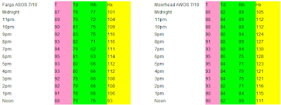

There are countless other examples of "corn effect" heat in these heat waves -- parts of Iowa and other parts of Minnesota had heat index values over 120 thanks to observation sites in the midst or near a farm field.   While some of the dew point values reached in the heat wave in the Midwest were legitimate -- the 82 in Minneapolis is a definite "legit" record since their airport is just about smack dab in the middle of the metropolitan area, the mid and upper 80's dew point values in some of the rural areas are likely enhanced thanks to what may be on someone's dinner plate, feeding trough, or gas tank (ethanol) in a few weeks.   There's no denying the heat or even the humidity in many locations but understanding should be taken when analyzing some of the more extreme data due to location and what surrounds it.

All I can ask is that tomorrow we don't get a dew point in the low 80's with any temperatures over 100...I don't think the region needs a repeat of July 1995 around here.

July 22nd, 2011 Forecast

Tonight: Mostly clear skies. Haze will lead to some patchy fog forming late tonight due to all the moisture in the atmosphere from high dew points in the mid-70s. It will be a very warm and muggy night with lows not likely dropping below 80 degrees in Philadelphia. Winds will be out of the southwest at 5 to 10 mph. The sunset tonight is at 8:25 PM.

Friday: Hazy sun, blazing hot, and humid. The high will approach 100 degrees in Philadelphia with heat index values between 105 and 112. The record high is 100 degrees, set back in 1957, so this record will likely be tied if not broken. There is a 20 percent chance of an isolated thunderstorm in the evening, but most of us will not see this. Winds will be out of the west at 5 to 15 mph, which is ideal for 100 degree weather in our area due to the downslope wind off of the Appalachian Mountains.

Saturday: Hazy sun, very hot, and humid. The high will be near 98 degrees with a heat index between 104 and 110. There is a 20 percent chance of a late-day or evening thunderstorm, but once again most of us will not see this. The record high of 99 degrees, set back in 1991, should be safe.

Sunday: Hazy sun, hot, and humid. The high will be around 94 degrees with a heat index close to 100. There is a 30 percent chance of a pop-up afternoon thunderstorm. The record high of 97 degrees, set just last year in 2010, will be safe.

Friday Planner

7 AM 82 degrees, Hazy Sun

Noon 96 degrees, Humid

5 PM High around 100 degrees, Feels Like 105 to 112

Sunrise 5:51 AM
Sunset 8:24 PM

Heat Ridge About To Pump Temps Up

We're starting the core and prime heat days of our heat wave today, with three days of nastiness ahead where temperatures and dew points combine to make it feel like it's over 100 each afternoon...perhaps even as high as 110 in the prime heat of the day tomorrow afternoon.   Some low clouds, haze, and light fog graze the region this morning as residual less hot air from yesterday lingers while the heat ridge bubbles in from the southwest.   Temperatures are starting out on the toasty side regardless -- generally in the 70's and on the way to topping out well into the 90's by day's end.

Nationally, the main focus of the heat is shifting a bit to the east and southeast from its position of the past few days.   Minnesota and most of the Upper Midwest have seen the passage of a cool front and the introduction of some relief in the temperatures and humidity, with the heat dome shifting to the Ohio Valley and Appalachians for the next few days.  You can see the vast swath of real estate that are under some form of heat advisory, warning, or watch over the next couple of days (inland areas in a red shading) -- effectively close to 2000 miles from Massachusetts to Oklahoma.   Locally, we're under an excessive heat warning through Saturday.

Today's peak heat features heat index values between 102 and 107.   Based on an assumption that we reach high temperatures from 94-97 locally, with dew point values in the low or middle 70's, the heat index below is calculated for a number of different locations based on different combinations.   Even with a lower high temperature, a higher dew point can offset the "cooling" benefit of three degrees and give you an apparent temperature as high, if not higher, than the heat index of a locale with a higher temperature and lower dew point.   That's why it's more critical to know what the heat index is as opposed to simply knowing how high the air temperature is.    All of the air temperatures over the next three days will be hot -- perhaps record breaking in spots -- but the bigger story will be the combination of this heat with dew points that are borderline tropical.   That combination compounds air temperatures in the upper 90's or 100ish and makes it feel like it's a good 5-12 degrees warmer.
Most of us would probably feel better if we were talking about subzero wind chills this morning and not heat index values in the 100's or low 110's!   Regardless, stay cool (or as cool as possible) and drink lots of water.

More:  Current Weather Page

Dangerous Heat...


The heat will be up into the dangerous levels over the next few days. For the I-85 corridor, look for highs in the upper 90s to near 100 today into the weekend. For the I-95 corridor into the Sandhills, highs will exceed 100 in many spots.

When you factor the humidity into the equation, heat index values will exceed 105 at times, and that is dangerous type of heat. Some spots could see heat index values exceeding 110.

Please use lots of caution if you have to be outside for any extended period of time. Take frequent breaks in the air conditioning, and drink plenty of water. Also, please check on anybody that doesn't have air conditioning. Make sure your pets have plenty of fresh, cold water.

A few isolated storms will fire off the next few afternoons, but they will be few and far between. The storm chances look a little better for Sunday and especially Monday.

I still think we get a brief break from the heat Monday and Tuesday, but it sure looks like another big ridge will develop right overhead by the second half of next week, meaning another wave of heat.

Tropics....

Two tropical storms out there.....Bret and Cindy. Both are fish storms and will not impact land.