Kamis, 31 Maret 2011

12z Euro thoughts...

Just a quick note from the 12z Euro valid next Tuesday...this system will likely wind up being a widespread severe weather producer....and that threat could very well extend up a good portion of the eastern seaboard. Check out the energy in the base of the trough swinging into the region. The Euro also develops a little meso-low type feature that would likely enhance local helicities if
it verified.


Here is the meso-low feature....

Slowly Coming Together...Too Slowly


With the evening now upon us, radar is showing the couple of pieces for this storm trying to come together.   The storm is organizing a bit farther offshore than most model guidance anticipated (NAM was the exception) and is coming together more slowly as the upper trough isn't digging as sharply...instead it's shearing the storm a bit due to a more broad nature of alignment (U shaped, not a sharp V trough that helps in rapid intensification).   As such, the storm is spitting rain across the region but is not developing at an explosive enough clip to provide the ingredients necessary for a widespread snow thump across the higher elevations to our north.

Hope is not lost for the Pocono snowstarved overnight -- energy back across West Virginia this evening will lift through and will likely provide enough juice to the atmosphere to allow for rain to change to snow in the higher elevations of the Poconos and perhaps down to Allentown overnight.   Some snowflakes could mix in across Upper Bucks, Montgomery, and Chester Counties -- particularly over the higher elevations.

With that said, while the storm is slow to develop it doesn't mean that it won't rain...even steady at times overnight.   It's not going to be completely "dudsville" but rain will fall off and on overnight and is upper level energy fuses in later we can see some changeover taking place.

Snowfall totals for the region:

Allentown:  Around 1"
Poconos and North Jersey below 1500' elevation:  1-3"
Poconos and North Jersey above 1500' elevation:  3-7"

We'll see if Mother Nature pulls another trick from her sleeve overnight but based on the slower and more eastern development of the storm this is probably what will fall overnight.

More:   Current Weather Page

April 1st, 2011 Forecast

Tonight's rain to snow scenario for the higher elevations north of the city makes for a tricky forecast -- some areas will not do so well in snow while others will overperform in the snowfall department.   Right now, the thinking here is that the heaviest snowfall should occur in the Poconos and Northwest New Jersey, with the Lehigh Valley seeing a rain ending as snow scenario that could accumulate to a couple of inches.    Rain could mix with snow at the end of the event in Philadelphia but accumulations in the city are not likely.

Most of the rain (and snow) should end during the early morning hours, tapering off from south to north and exiting the city around 7 or 8 AM.   This should mean, provided no "surprises" from Mother Nature, that we get the ballgame in tomorrow on time...although a shower can't be ruled out during the game.   It will be breezy at times tomorrow, with winds veering around to the north tonight and increasing tomorrow to 12-18 mph, perhaps gusting above 30 mph.

Lows tonight will drop into the 30's for many, with highs on Friday generally in the mid and upper 40's for most locations and some low 50's across South Jersey and Delaware.   A few breaks in the clouds can't be ruled out in the evening hours on Friday.


Weekend Sneak Peek:  Saturday could feature some flurries or sprinkles passing through the region in association with upper level energy rotating around the developed storm that will have moved into Eastern Canada.   Otherwise, it will be blustery and variably cloudy with temperatures around 50.   Sunday will feature mostly sunny skies and calmer weather overall with highs in the mid 50's.

Snowfall Forecast:   Expect a snowfall forecast for the region late this afternoon.

Another shot of rain today...changes ahead...

Here is today's edition of the Carolina Weather Video. In it, I discuss some additional rain moving through the region today, some milder, drier weather beginning tomorrow, and take a look at next week.

Dribs & Drabs To Start


This morning is damp, dreary, and full of dribs and drabs of drizzle and drops of rain.   Enough d's in that sentence?   Yeah, it's a D- type of weather day unless you are a duck or any other associated type of waterfowl as clouds, drizzle, and showers strut around the region as wave #1 of low pressure pulls off the coast this morning.   You can see the radar up above showing the widespread drizzle and drips through the region -- some of the precipitation that fell last night mixed with snow in the higher elevations to the west of the city and in fact, it was snowing lightly last night on top of the higher skyscrapers in the city (on top of the Comcast Center and the Liberty skyscrapers, all of which 900' or more in the sky).

We could see a bit of a break (er, lull) in precipitation between waves around midday but it's not a certainty as we could see this drizzly drear linger through the entire day.

Wave #2 is organizing across the Southeast and will steadily march northeast today, eventually causing more rain to break out to our south later on this afternoon.  Wave #2 should spread into the Philadelphia region after 4 PM, with rain moving in and through the region this evening.   Said rain will change to snow in the higher elevations to our north, with the Poconos poised to pick up several inches of snow tonight and early tomorrow.   Winter Storm Warnings are out for the Lehigh Valley, the Poconos, and Northwest New Jersey for tonight and tomorrow morning as those areas stand the best chance of getting hit with significant snow.   Philly may see a mix of rain and snow at the end but odds for accumulating snow in the city are pretty low.

We'll have a snowfall forecast out late this afternoon for the storm.

More:   Current Weather Page

Rabu, 30 Maret 2011

April Fools' Storm A Day Away


We're a bit less than 24 hours away from the April Fools' Storm's arrival in the region, with a soggy start and for those north & west of the city, a snowy ending as the storm intensifies tomorrow night and early Friday, leading to a transition from rain to snow for higher elevations north of the city.   The potential does exist for significant accumulations in the Poconos, the higher elevations of the Lehigh Valley, and North Jersey -- Winter Storm Watches are out for those areas.  

For the city, the "best" chances for snow will come at the end of the event on Friday morning as the heaviest precipitation is pulling away and colder air pulls in aloft.  We might get a brief mix in the city and the immediate burbs.   Computer guidance is suggesting that snow should accumulate to the north of the city -- after starting as rain -- as the storm intensifies and cold air ingests into the storm's western flank.  However, not everyone on the western flank will see snow.  Elevation helps -- if you're in the Poconos you'll probably get a good bit of snow.  Likewise, those in the upper parts of Bucks and Chester Counties should get some accumulations as well.   However, valleys and the urban core of I-95 will likely stay mostly rain.


Timing-wise, any transition of rain to snow should take place in the late evening or overnight hours on Thursday -- after rain starts up on the front end tomorrow afternoon or early evening.   Snow accumulation could be fast/furious over the higher elevations -- perhaps two inches per hour in the Poconos.   How quickly that snow fires up is dependent on how quickly the storm intensifies.   A slower intensification means less snow overall.   We'll have an accumulation forecast for the storm out tomorrow afternoon.

As far as Philadelphia is concerned, this should be a mainly rain event and should be over early Friday morning...perhaps during the morning commute.  Assuming no unforeseen accumulations of snow overnight tomorrow, the game may be delayed out of the gate but it looks like the Phillies have a decent shot of playing on Friday.   As always, stay tuned.

Opening Day & Weather Together

Tomorrow marks the first day of the 2011 MLB Season -- a first in a long time for baseball to start its season in the middle of the week as opposed to the early parts of the week, which have been the "traditional" opening day(s) for baseball teams for nearly 30 years.   The last time the Phillies didn't open on either Sunday, Monday, or Tuesday was in 1995, when their season started on a Wednesday in St. Louis (thank you 1994 Strike).  The 1982 season was the last time a regularly scheduled (and fully played) season started late week.   The switch to a late week start was made in order to start the season for everyone on/around April 1st and, more importantly, get the postseason done by the end of October so games wouldn't be played too late into November going forward.

Weather-wise, the eastern and northeastern parts of the country will have the most risk for delays and cancellations between Thursday night and Friday.  Given that the Yankees play Thursday during the day and not Friday, that the Red Sox are in Texas, and the Mets are in South Florida that leaves the Phillies.   Timing-wise, the storm is looking (as of midday) like it should be out of Philadelphia comfortably in time for the scheduled 1:05 PM start.   Whether the precipitation type in this storm is willing to cooperate (rain is better in this case than snow) remains to be seen but the Phillies game does have the "best" chance to have some sort of delay or postponement.   The Yankees game could run into some rain during the late afternoon hours, particularly towards dinner, as rain from the potential coastal storm begins to work up the coast.

While the rest of the country should have better weather, the Midwest could see some showers, which may dampen play in St. Louis and Kansas City tomorrow.  Other than that, much of the country should enjoy decent weather and in the West and South, rather warm temperatures for the end of March and beginning of April.   At least someone is enjoying Spring!

March 31st, 2011 Forecast

Thursday features a day of damp transition between storm systems...the first of which impacts us tonight with light rain and drizzle, the second of which moves in late in the day tomorrow with steadier rain and perhaps some snow depending on intensity of the storm.   In between, drizzle, clouds, and a generally dreary end to a varied month of weather.

Tonight's light rain and drizzle may mix with a few snowflakes in a few spots but accumulations don't look likely in the region tonight.  Expect low temperatures overnight in the middle 30's across the region with winds nudging to the east at 5-10 mph.   Thursday's temperatures will top out in the middle and upper 40's -- clouds will rule the day -- with winds nudging to the northeast at 6-12 mph, increasing Thursday night as the second storm winds up.   Event #2 should start up in the late afternoon tomorrow -- continuing through the night before ending before Friday morning.   Stay tuned though as the forecast could change later this evening...we'll have more on it after dinner.

Occasional rain with chilly temps today...

Two systems impacting our region over the next 36 hours....then another strong system early next week. Lots to talk about in today's video...

Late Day & Evening Showers


Today's 'event' is not a big deal -- and will mostly be liquid given current trends in precipitation intensity, timing, and temperatures at the surface.   Precipitation is starting to break out across Virginia and extends back into Ohio and Indiana -- with the radar returns to our south in Maryland not reaching the ground early this morning.   Expect a slow and steady increase in cloud cover through the day today, with showers possible after 4 PM as the first of two storm systems moves east.

Precipitation will occur through the evening hours -- steadier after 7 or 8 PM, especially south/east of the city -- before precipitation winds down early Thursday morning.   Some of the rain could mix with snowflakes but accumulating snow does not look likely from this first event.

Briefly updating the second event, computer guidance is still showing the storm system on the board for Thursday night into Friday morning.  The "earlier" guidance on the GFS seems to be winning out, meaning that rain (and any snow that falls/accumulates) pulls out on Friday morning.  The snow question is still to be answered and much of that will be determined by how quickly the storm intensifies, but if the city receives just rain the game should be able to get played on Friday.    We'll update you on the progress of this later on today...

More:   Current Weather

Selasa, 29 Maret 2011

No Foolin'

The two systems of note for the upcoming several days are going to be completely different in terms of impact and in terms of "how much" for the region as they move through.  Event #1, which is timed to move through starting Wednesday in the late afternoon and evening hours, should generally bring little more than passing light rain, drizzle, or even a few mixed in snowflakes to the Philadelphia region.   Accumulations aren't likely although a rogue coating could accumulate Wednesday night in some grassy locations south and east of town as light rain transitions over to light snow after sunset.   With temperatures generally comfortably above freezing and precipitation generally rather light, not much impact is expected from this event.

Event #2, however, is a different beast.   Computer model guidance is generally agreeing on a storm intensifying off of the Southeast coast and lifting northeast late Thursday night and Friday morning.   The Euro, GFS, and Canadian all agree on a storm taking shape and quickly intensifying as it lifts up the East Coast...with the potential for significant wind, rain...and snow for some areas north and northwest of Philadelphia.   The Euro, shown below, shows the precipitation from 8 AM to 2 PM with heavy precipitation falling along the Delaware River to the north of the city.   The GFS shows similar but on a faster track (about six hours faster than the Euro).


Systems like this have the potential of throwing some surprises out there -- especially in the areas of heaviest precipitation where cooling of the atmosphere is sufficient to allow rain to transition to snow.   Elevation helps -- the northern and western burbs have it...south and east does not...in this case, given a track relatively close to the coast it will help to have elevation working in one's favor.

Putting all of that into the blender, the Friday storm is looking like the stronger of the two and more importantly, the potential exists in storm #2 for some snow in some locations.   In terms of impacts on those at the ballpark on Friday -- well, if it does indeed snow in Philadelphia the likelihood of a postponed game is higher than if we have an overnight rainstorm in the city that ends around 10 AM...the ballpark will be wet, perhaps the first pitch will be delayed, but the game can be played on a wet field...snow...well, it would be fun  to watch from the comforts of home or bar, but miserable to watch melt.   Odds, now, lean towards some city possible in the city but how much, timing, etc. remains to be determined.   Any snow that does fall, however, will be of the high density (concrete) variety.

Unfortunately -- assuming the storm does happen -- Mother Nature will win with the best of April Fools' jokes on those who want warmer weather.

March 30th, 2011 Forecast

It is going to be unsettled for the remainder of the week. It is also going to stay cool for at least the next 5 days. The normal high for this time of year is 56 degrees, and we won't even get above that number until Monday at the earliest. Writing this blog post from Oswego, NY, I must say that 40s and 50s would feel warm to me right now because most of New York State has been stuck in the 20s (yes...20s) and 30s for highs the past several days. We have no shot at 50 degrees anytime soon up here. We even got a couple inches of accumulating snow last week, and some scattered snow showers since then. Spring is out there somewhere...just not in the northeast.

Tonight: Mostly clear evening, becoming partly cloudy overnight. Lows will range from 25 to 32 degrees. Northwest winds will shift from the north 5 to 15 mph. The sunset tonight is at 7:22 PM.

Wednesday: Sun to clouds, shower or sprinkle after 2 PM. Highs will range from 44 to 48 degrees. North winds will shift from the south-southwest 5 to 15 mph. The chance of rain is about 30 percent.

Thursday: Mostly cloudy and cool. We should stay dry during the daylight hours. Expect a high near 50 degrees. Rain is possible at night (60 percent chance).

Friday: Rain is possible, especially in the morning, otherwise mainly gray skies and windy. Snow will be possible in the Poconos due to temperatures in the lower to mid-30s up there. The high in Philadelphia will be around 49 degrees. The chance of rain is about 60 percent.

Wednesday Planner

7 AM 32 degrees, Cool

Noon 44 degrees, Sun to Clouds

5 PM High near 48 degrees, Shower / Sprinkle

Sunrise 6:49 AM
Sunset 7:23 PM

Milder today, but chilly and rainy tomorrow...

Here is today's edition of the Carolina Weather Video. A parade of disturbances is rolling our way...I take a look at how things shape up for the next week for us.

Senin, 28 Maret 2011

Uncertainty After Tomorrow

We're about 48 hours out from the first of what looks like two storm systems this week...and computer modeling differs quite a bit over details on what ultimately falls for the region on Wednesday afternoon and evening.

First, the NAM and GFS (the GFS is shown below) are suggesting nothing of note around the region -- with just a few lite showers on the GFS south/west of the city as the storm takes on a suppressed track off of the Carolinas.   If the GFS and NAM are ultimately right Wednesday will just be cloudy with perhaps little more than a few drops/flakes/drizzle in the evening hours as the limited moisture crosses the region.   Steadier precipitation would fall from Dover on south, in line with what ultimately happened early Sunday morning across the Delmarva.


The GFS and NAM are in agreement around a modest...or nothing event...however, the Euro is still rather potent with the low, spinning it up into a stronger system and thereby throwing more moisture into the region.   The potential for late afternoon through evening rain and snow mixed is still in play on the Euro, with rain from the city on south and probably some wet snow mixing in, perhaps even accumulating briefly, across the north and west suburbs if the Euro is right.    We're not talking major accumulations but an inch, perhaps two if the Euro is right.


The first storm may ultimately play into how the second storm develops and tracks. Computer guidance is equally waffling over the second storm on Friday, with the Euro playing down this storm (generally light precipitation, a "meh" event that probably doesn't even delay the game) while the GFS plays up the second storm into a two wave event...first wave on Friday morning, second wave on Friday night and Saturday morning.   The first wave brings rain to the region, with Saturday's wave possibly bringing some snow to the Lehigh Valley and Poconos.  

Friday doesn't look the best of weather days regardless of the final forecast -- it does look unsettled at best with mainly cloudy skies in the best case scenario, rainy in the worst case.  In between, it could be a drop dodge during the game but nothing that could prevent a game from taking place....just not in the nicest of weather situations.

March 29th, 2011 Forecast

 A sunny, brisk, early Spring day...been part of the familiar trend of late.  That same trend continues tomorrow as we continue in a decent northwest wind flow brought to you by low pressure off of Newfoundland and a strong high over the Great Lakes.  That pressure gradient between the two has to push some winds down somewhere...and it means cool air continues to flow freely into the Northeast.   While tomorrow will be a few degrees milder, we'll be one day closer to a southern system that will scoot along with some light rain and/or snow for Wednesday PM and Wednesday night.

Lows tonight will range from 21 in the Lehigh Valley's coolest spots to the upper 20's in Center City, with highs on Tuesday ranging from 44-50 region wide with mostly sunny skies.   Tuesday's breezes could gust back over 20 mph in the afternoon.


We'll update the Wednesday system and the potential April Fools' system this evening.

Some morning snow and rain...

Here is today's edition of the Carolina Weather Video. Give it a look.


We will have some rain and snow press through the region this morning. From roughly Hwy 64 and points north, the temperatures aloft are cold enough to support snow at least mixing in as the precip settles in. In some areas, the precip will likely be mainly snow for a while later this morning. Ground temps are fairly warm, so the roads should only be wet. However, especially from I-40 and points north, grassy and elevated surfaces could get whitened. Really, anybody in the Piedmont is fair game to see at least some wet flakes mix in this morning.

More cool weather and more systems on the way this week....see the video for more.

Minggu, 27 Maret 2011

Will It Be One Or Two Storms?

Computer guidance for the last several days has been hinting at a potential for a storm system this week...and in some cases, hinting at two storm systems -- one on Wednesday into Thursday and the other on Friday into Saturday.   There's been a good deal of uncertainty over which of the two storm systems would be the bigger/stronger of the two - whether it would be the midweek system or a potential storm on April Fools' Day.   The stronger April Fools storm would require a weaker midweek storm while a stronger midweek storm may limit the potential for the April Fools system to pop up.

As of this afternoon's guidance, we're still up in the air in terms of which storm ultimately ends up stronger but it does look like we're going to have two events to track this week.   It's not a certainty but there is relative agreement from the GFS and Euro around a storm tracking to the south of Philadelphia during Wednesday evening and night.   The Euro (below) is a stronger storm of the two and is showing a mixed bag of precipitation -- temperatures at the magic 5000' level would be cold enough for snow but temperatures show enough moderation in temperature in the atmosphere to make this a less snowy situation.

The GFS (below) is weaker and warmer, with precipitation much lighter than on the Euro and the storm system generally a light rain maker for Wednesday night and early Thursday.  The GFS' more minor presentation of this storm helps prop up a bit of a stronger storm on Friday night for the East Coast than toady's Euro.  Both models bring a chance of either rain or snow for Friday night, with the GFS bringing a bit more moisture in this storm -- it's not a full blown coastal storm like some past runs of the model (and the Euro) have shown but it does still hold onto the second system potential.


The week at large continues to suggest below average temperatures and a cool regime holding in the East into early April.

Weather Rewind, March 20-26, 2011

Last week's temperatures were 3.4 degrees below average as our month long warm spell came to a resounding end after our journey to near 80 degrees late in the prior week.   While temperatures started last week on a relatively mild note (cracking 60 on Monday), cooler air surged south for the latter half of the week as temperatures were consistently several degrees below average from Thursday on.

Precipitation totaled 0.65" last week -- most of it falling on Monday with Wednesday's precipitation totals higher north of the city (where much of it fell as snow north of I-78), accompanied by a round of thunderstorms that brought small hail and sleet to the region during Wednesday evening.  

The pattern nationally saw a pretty decent shift thanks to the development of a -NAO pattern, which helped drive down colder air into the Northeast.  The South is still quite warm thanks to a ridge of high pressure over the Deep South -- a trend that will likely continue in the coming weeks.   The North and West remain chilled for the most part thanks to a rough in the West and the -NAO for the northern tier of the country.

March 28th, 2011 Forecast

The theme on Monday will be much the same as Friday and Saturday were -- cool temperatures, occasional breezes, and lots of sunshine.  The good news is that the last couple of days have been warm in the sun...as long as the wind didn't blow much!   Expect another cool day across the Delaware Valley on Monday though as temperatures continue to remain several degrees below average.

Lows tonight range from the lower 20's in the Lehigh Valley to the upper 20's in Center City, with highs on Monday ranging from the lower 40's north to mid 40's around Philadelphia and points south.   Winds tonight will be northwest at 5-10 mph, winds on Monday northwest at 10-15 mph.   Some passing clouds are possible later tonight and on Monday morning as mid level energy passes to our south.


The Week Ahead:   I'll have more detail on the uncertainty for the latter half of the week later on this evening but after Tuesday's sunshine, things go downhill for the end of the week.  The forecast is uncertain and computer guidance is waffling on a couple of storm systems but there are chances for precipitation on Wednesday afternoon/evening and again on Friday.  Uncertainty exists on Wednesday's system over timing and track (some guidance is suggesting outright miss or a lingering of the system into Thursday) while on Friday it exists over whether the storm fires up or not as a stronger storm midweek would likely inhibit the Friday event.    It does look like another cool week around here regardless of how many storms do ultimately develop.

Light Snow Scooting South

Not all that impressive but this morning's light snow system is tracking along to the east, bringing light snow to the Delmarva, including parts of Southern Delaware where an inch or two of snow can't be ruled out this morning.   Winter Weather Advisories are out for Sussex County in Delaware until Noon.   While radar returns show some light precipitation over New Jersey, nothing is falling from the sky at this point.   Most, if any precipitation, should be confined to Sussex County and perhaps Cape May through midday before precipitation cuts off.

Sunshine will gradually...and slowly...return from north to south through the next several hours as this system pulls off the coast.  Expect another cool afternoon as the region struggles to get into the mid 40's for high temperatures.

More:   Current Weather Page

Sabtu, 26 Maret 2011

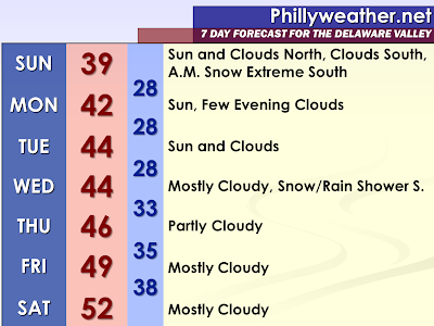
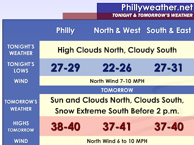
Extended Forecast for Sunday, March 27, 2011


The well-advertised southern storm system, being surprised by a strong Greenland block of high pressure centered in Canada, will pass south of region on Sunday Morning. Besides additional clouds in the southern portion of our region, the affects will not be too large. In fact, Sunday could have glimpses of sunshine in the northern half of the region. Some clearing could even begin in the southern portions of our region during the late afternoon hours with some sun possible before sunset.

Sussex County, Delaware has been placed under a winter weather advisory. The latest North American Model from 18z just coming in is showing accumulating snow with a sharp cutoff in the measurable snow right along the Delaware and Maryland state lines. However, given that there is a chance of a northward jog and it being so close, there is the chance measurable snow makes it into Sussex County. A line from Kent County to Cape May County may deal with some snow showers that could put down a scattered coating according to the NAM. It is interesting that the latest North American Model would have the potential for a narrow strip of a snowstorm around the southern Delmarva in Maryland. This narrow corridor would miss the southern portions of Delaware by about 40 miles or less. The narrowness of the corridor is because of the lack of moisture to the north and the warmer temperatures to the south. Someone could hit the jackpot early Sunday down in the Delmarva if all the cards fall in the right place. Meanwhile, the GFS doesn’t hint at this narrow band, but it shows measurable snow even making into Kent County. So, the extended graphic and near term graphic will make mention to clouds south, snow far south, and glimpses of sun north for Sunday. The cloudy and overcast areas may see temperatures only as high as 38 or 39 degrees and the northern areas (without the snow cover) could actually be warmer.

Monday and Tuesday appear to be looking colder and colder with the Canadian high pressure region maintaining a firm grip on the region. Therefore, I have lowered the temperatures from the previous forecast.

This takes us to Wednesday now which appears to also be colder. The long range models, particular the Global Forecast System run from 12z show the strong block trying to maintain a presence over the region. If this was the case, the moisture will be suppressed further south and air could very well be cold enough for at least mixed showers, if not all snow showers. The latest GFS would have little precipitation north a period of precipitation south. Once again, this forecast is colder than the previous one. The 18z NAM is faster with this energy and so far south that not a person in our area catches a flake. It appears this system is looking less and less ominous for our region. The Southeastern United States will potentially be active with severe weather outbreaks and flash floods.

Severe weather in the South today...


The SPC has put out a 'moderate' risk of severe weather for portions of Alabama and Mississippi this afternoon into tonight, and a tornado watch will soon be issued. Frankly, the severe weather indices are through the roof. All of the ingredients necessary for a severe weather outbreak seem to be in place. Places such as Birmingham and Starkville were already into the lower 70s for temps as of 11am central time, and dewpoints were in the low to mid 60s. The cloud cover is also broken enough that intervals of sun are getting through.

A similar setup to today that is being discussed is March 27, 1994. That was the infamous Palm Sunday tornado outbreak. There are some differences (such as that day, the tornadoes wound up making it all of the way up into the southern Piedmont of NC...that won't happen today), but for Alabama especially, the setup is very similar. Sky-high indices, a front draped west-to east across the north-central part of the state, and a primed atmosphere. Like that day 17 years ago, the severe weather will likely come in multiple waves this afternoon into tonight...not just one big round of severe weather.


For NC, a chilly, dreary day with many Piedmont spots in the 40s. Feels like Winter out there.


App'd Up Weather

My wife's Christmas gift to me this past year was an iPad...no, I'm not upset about her not waiting to get the iPad 2 since I'm not inclined to go around and take pictures with a 10" tablet computer.   Since last Christmas, I've been toying around with it finding good weather apps...free ones of course...in the time I haven't been playing Angry Birds.  I thought it would be worth sharing a few of those good apps with you or other iPad users.

First, Wundermap from Wunderground.   Arguably the best weather app I have found in terms of getting temperature, radar, satellite, and weather information in a single interface.   You can set the level of temperature reports to include personalized weather stations...or if you're an "ob snob" like I am simply have it report official observations (from Philadelphia, AC, etc.), just like the wundermap on the web.  It includes a pretty accurate radar and satellite overlay, warning information, and forecast.  Not intrusive, no ads, quick to zoom in and out based on your preference.   Simple but if you just want temp and radar without much fuss, it's probably your best bet in the app world at this point.

The Weather Channel Max for iPad is pretty similar to Wunderground's app in that it will let you move around from place to place to get temps.   It has different overlays by clicking "maps" for everything from how much rain fell the last 24 hours to UV index data at a given time in the day (won't do much good at 6 AM obviously).  It does have ads across the top and does not have the same temperature functionality as wunderground, meaning you have to type in a location to get the specific temperature.   It does, however, include video and "tweets" from TWC meteorologists.   It's not as "hardcore" for weather geeks but does serve a great purpose in filling a niche of information for one specific location...just not quite as "awesome" as Wundermap in my opinion.

Intellicast HD is pretty slick as well.   It has similar layout to TWC but instead of having to click on "local" to get a forecast the information is on the left hand (sideways) or bottom (not sideways) of the map.   Radar is accurate, provides a loop history, and their forecast tab includes graphs for what will happen over the course of a ten day period of time as well as an hourly chart of what will happen.  It is ad-supported (it is free, of course) but I do like having a ton of information in one spot.   You can have multiple cities linked across the top of the app (the default is Boston but you can list Timbuktu if you'd like by clicking the home button and then the "plus" sign) but it will only focus on information for one city at a time.   It doesn't have the other bells and whistles of TWC's app (no video, no twitter) but it does provide a better overall snapshot of information in one spot.

AccuWeather's app contains current weather information (obviously) but also weather headlines, forecast, video, and maps.   It's relatively easy to use, at least in my opinion, but tends to crash more frequently than the other weather apps I have used, especially when ads kick in (it is ad supported).   In fact, I've had to delete and reinstall a couple times...after the third crash, I pretty much gave up using it.

I will be curious to see how iHurricane works during the summer -- I downloaded it and it includes basic information like forecast discussion from the National Hurricane Center, computer model plots, and satellite imagery.   It will also provide a link to show storm tracks with clickable advisory information.   The advisory shows how far the storm is away from your location (that's pretty cool).   Too early to say with certainty if this will become one of my favs or not but it has potential.

There are other apps out there -- some ok, some terrible, and a bunch of apps that cost various amounts of money.   I may splurge on some of the at-cost apps in the future, especially if I purchase an iPhone and want to have access to computer models or in depth radar on the go (there are some impressive pay apps I've seen  demos on).   Until then, if it's free it's for me.  

Jumat, 25 Maret 2011

Blast From The Past: Before Million Watt Dopplers


I love this clip during the Superstorm of '93 -- I stumbled upon it today and got a kick out of it.  The radar technology that Channel 3 was using at the time is hilarious compared to having radars that can zoom in on one's head and talk about the sweat forming on someone's brow, or weather apps that give you time, temperature, sun angle, or nearly whatever your heart desires.  

It makes you wonder where we'll be in the realm of technology within the next 20 years.  iPad's with personalized and built-in doppler radars?

March 26th and 27th, 2011 Forecast

A cool weekend is on tap for the Delaware Valley, with a  minor southern system scooting through on Sunday.  This system will spread some light snow across Delaware and possibly South Jersey early in the day, helping to keep the cool nudge in place throughout the region for the start of next week.  Saturday will be the nicer of the two weekend days as skies will feature a mix of sun and clouds.

Lows at night for both Friday night and Saturday night will generally bottom out in the lower 20's north to the mid 20's in the burbs and upper 20's in Philadelphia.   Daytime highs on Saturday will be a a couple of degrees higher than on Sunday due to additional sunshine -- expect lower and middle 40's on Saturday, 40-42 on Sunday due to the extra clouds and some precipitation.   Winds through the weekend will be light, generally northwest at 5-10 mph.

Snowfall projections for Delaware and South Jersey are modest -- maybe an inch, perhaps two in Sussex County, Delaware...especially right along the MD/DE border.  Flurries could occur up to Smyrna, perhaps to Atlantic City.   A northward nudge could increase those totals and bring the axis of snow closer to Philly but odds favor this system missing the city and holding to a southern track.   It doesn't mean sunshine and shorts weather, obviously, for Sunday, but it will mean dry weather.


We'll provide an update over the weekend on the Sunday system and let you know if there are any changes in track or intensity, as well as talk about the next "big" system in the pipeline for next week as we work through the weekend.

Chilly, occasionally rainy weekend ahead...

**No video today due to double-market duty on News 14 this morning.**

Dry conditions today with highs ranging from the upper 50s to the low to mid 60s. This comes after a cold, frosty start to the day with lots of lows in the 30s.

The weekend continues to look chilly with occasional waves of rain moving through.Rain will spread in from west to east tomorrow, and when the rain arrives in your back yard will determine how warm you get. Up around the VA border region, highs probably never make it to 50. Maybe low to mid 50s across the southern Piedmont. Look for similar, even maybe chillier, temps Sunday.

If this pattern were occurring a few weeks ago, we would be discussing how much snow and ice we would be getting. Snow will wind up pretty far south...into southern Virginia even.

A couple more systems are lined up for next week...one around Tuesday night and another late Thursday into Friday. So, the cooler, more active pattern will continue.

Kamis, 24 Maret 2011

Sunday Snow To The South?

The earlier mentioned light snow/rain event for Sunday continues to show up in the models -- with some variation by model regarding timing and track.   The northernmost track resides in the Euro, which is also the most moist and also the fastest of the three guidance.  The Euro is primarily an early Sunday morning timeframe for the track of the storm system through the Mid Atlantic, resulting in snow for  most of the region since it would arrive in the pre-dawn hours and the atmosphere will probably be cold enough for it.   The Euro track brings precipitation closest to the Philadelphia area, generally keeping it confined to Delaware and South Jersey with only light echoes (flurries, snow shower?) across the Philly region if it's right.

The GFS is slightly south of the Euro and the slowest, with timing supporting a mixed bag event as it moves through around midday Sunday on its version of the system.   The NAM, not shown either, is a bit south of the GFS and is in line with the Euro on timing (Sunday AM).   The NAM keeps any precipitation south of Philadelphia altogether.

Given the track of this system looks like it will pass to the south of the city by a good bit, the farther south one resides the better their chances for a light snow event, especially if the faster NAM/EURO timing verifies.   An inch or two of slush can't be ruled out for Dover, Cape May, perhaps Atlantic City.   We'll update this over the weekend as the storm approaches and moves on through early Sunday.

March 25th, 2011 Forecast

By late March standards, the next few days are going to be pretty cool as a northwesterly flow at the surface and aloft help remind us all that despite being in Spring things don't transition to warmth all that smoothly.  Expect a few cool to chilly days forthcoming.  At least sunshine will be out and about tomorrow and Saturday to ease the last swipes of winter chill.

Tonight:   Clearing out and cooling off.  Lows by morning will range from 20 in the Lehigh Valley to the upper 20's in Center City.  Northwest winds will taper to 5-10 mph after sunset.

Friday:   Not a bad day...and if it were late February and not late March temperatures would not be all that bad.   However, highs in the lower and middle 40's are more typical for a month ago and not this time of year so it is going to be seasonably chilly out.  The good news is there will be mostly sunny skies.


Weekend Sneak Peek:   A storm system is poised to track to the south of the region on Sunday.   Model guidance as of this morning waffled on how close precipitation ultimately gets but my thinking, as of now, is to keep it south of the city for Sunday...and in the form of rain and snow (specific precip type is still up in the air but we're not looking at a major storm by any stretch).   Saturday will be the nicer of the two days regardless of location as Sunday will feature more clouds.  If the Sunday system tracks a bit more north and we get in on the rain/snow/slop temperatures may be hard pressed to hit 40 in the city.   We'll update this over the coming couple of days.

Cooler air settling in...

In today's video, a look back at the severe weather yesterday evening, a look ahead at the cooler temps settling in, including some frost chances, as well as a chilly, damp weekend. Plus, a look at the longer range.

Hail To The Sleet

Last night's thunderstorms were pretty "fun" to watch move through -- arguably less fun to drive through as the pinging of graupel, sleet, and hail hit windshields throughout the Delaware Valley during the 7:15-8:15 PM timeframe.   The National Weather Service is defining what fell last night as hail -- some places with slightly larger hail pellets than others -- but most of the reports that came in last night were classified as quarter inch hail.


One could realistically argue a case for sleet or graupel (hybrid of hail/sleet) as the precipitation type last night that fell -- the pellets that were falling were larger than traditional sleet pellets but weren't as "hard" as regular hail pellets...which makes me think a fair bit of graupel was falling in spots.  Hail certainly was do-able in many locations with these thunderstorms -- they were the remnant of severe thunderstorms that dropped a tornado across Western Pennsylvania (more on that in a bit) but given there was pretty significant instability aloft as well as cold pockets of air above a shallow mild layer in the bottom parts of the atmosphere the potential for sleet mixing in was legit, especially over the northern burbs as surface temperatures were in the 35-40 range during the event.

It can hail with temperatures in the 30's...it can sleet with temperatures in the 40's at the surface.   In this case, with temperatures around 40, it's possible we had both.


Dude...get inside the school...that's a tornado!   Yes, this tornado struck Hempfield High School in Greensburg, PA (out near Pittsburgh) yesterday afternoon with the complex of storms that hit Philadelphia later on last night.   While the caption in the linked video says he "overreacted" the best thing to do in a tornado is find shelter, even if it is in a large building (interior hall, basement if possible) as opposed to try to outrun it.  

From snow to thundersleet to hail, yesterday was a wild weather day in Pennsylvania -- especially since we had such a huge variation in weather over a short distance -- from 9-10" of snow in the Poconos to temperatures in the low 70's in Southwestern Pennsylvania.  Those types of extremes over 250 miles are "typical" of wacky early Spring storms.

Rabu, 23 Maret 2011

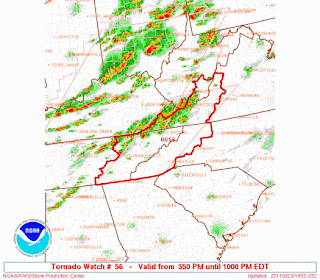
Tornado Watch


A tornado Watch has been issued for eastern Tennessee into western North Carolina(including all of the mountains and the northern foothills) and up into western CA and SE WVA. The watch is formally out until 10pm, but of course, counties will be cleared from west to east as the threat diminishes.

The biggest threats will be damaging winds and hail, but a few tornadoes are possible.

It is also possible that the severe threat will wind up extending farther east into NC and SC later this evening. Time will tell how much the storms weaken as instability wanes the farther east you go.

Tonight's Rain & Thunder Pops To The West

Update, 8 PM: A line of thundersleet (or thundergraupel) moved through over the last 30-45 minutes, bringing a brief downpour of rain, small hail/sleet pellets, and pretty frequent thunder depending on the cell that hit your location. These storms are moving through a region where the surface temperatures are in the mid and upper 30's but are remnants of more powerful thunderstorms that rocked Western Pennsylvania earlier this afternoon and evening, with tornado warnings in various parts of the state. These storms are now moving through South Jersey.

Another batch is in Central Pennsylvania -- yes, with embedded thunder and sleet as it moves east. Expect those storms in over the next hour or two.


With light rain and drizzle lurking around this afternoon (yes, snow/sleet/mix/slop to the north of us), the next rounds of precipitation lurk off to our west.   Rain showers across Central Pennsylvania will work east over the next few hours, with larger thunderstorms firing up across Ohio that will march east and impact the region after 8 PM.

If we work a beeline (crow fly line) straight east from where those thunderstorms are, the best chances for them to continue tracking look to be to the south of Philadelphia -- generally Maryland, Delaware, New Jersey.   Given the more stable and chilly environment over us compared to farther west (where Ohio and Southwest Pennsylvania plus West Virginia are under a Tornado Watch)  I don't think we'll see anything "nasty" in the severe department -- but a few rumbles of thunder can't be ruled out this evening and overnight as whatever is left over from those storms works through.  More rain may develop out ahead of the larger complex in Ohio and move through before then -- the point is, expect off and on rain from the city on south...especially later on.    Until then, drizzle, raw, chilly will be the rule into the evening.

Farther north, precipitation may cross in the form of rain, rain/sleet mix, rain/sleet/snow, slop, or snow depending on location, elevation, and precipitation intensity.  Higher elevations have had a good snowstorm so far -- 9" in Tobyhanna in the Poconos compared to 2" in Allentown.   Elevation may win with any further development in precipitation over the next several hours.  However, milder air aloft has made it as far north as Allentown and even into the valleys of Northeastern Pennsylvania and has turned things into a drizzly mess despite cold temperatures at the surface.

More:   Current Weather Page

March 24th, 2011 Forecast

Rain, falling on our heads here but falling as snow to our north, will gradually pull away later on tonight.  The storm system responsible for this mess is going to help entrench a cool regime over the Northeast into the weekend, keeping us several degrees below average.   The good news is that we'll get a chance to dry out...it just won't be very warm.

Tonight:   Rain (mix and snow to the north of the city) continues off and on until after Midnight, with embedded thunder from Philly on south.  Most of this will pick back up again after 6 PM after a lull over the next few hours. Temperatures will bottom out tonight in the lower and mid 30's north, perhaps staying above 40 farther to the south overnight.  Winds veer around to the northwest for all on the backside of the front at 6-12 mph.

Thursday:  Breezy, lingering clouds with a shower or flurry around for parts of the region through the morning hours.   Temperatures tomorrow will top out in the mid 40's in many locations, perhaps upper 40's to the south.   Winds will gust to over 20 mph at times from the northwest, adding a bit of a chill to the atmosphere.


We'll update this mess later on this afternoon or evening.

Warm Wednesday....changes on the way...


What an incredibly mild start to the day in the southern Piedmont and Upstate. At 5am, the CLT temp was 70! Low at CLT this morning was 63...only 3 shy of the warmest low on record for March 23.

Highs today for most should be in the low to mid 80s. Record highs will be challenged in Greensboro and Raleigh. It will also be pretty breezy, and the fire danger is pretty elevated today. So, avoid any outdoor burning.

There has been a little light rain in some spots already today, but the main shower and thunderstorm chance will run from later this afternoon through this evening. While the biggest severe weather risk is just to our north and west, I do think a few storms could produce damaging winds and maybe some hail. So, we will watch it closely.

Big-time pattern change....

Highs will be in the 60s tomorrow, then the downward temp trend continues through the weekend into early next week. It is a fairly chaotic pattern from this weekend through Tuesday with a series of low pressure areas moving through...the strongest of which will be the last one.

I will mention a chance of rain both weekend days, and then the final low likely moves through later Monday into Tuesday. Cold air damming will be involved much of the time, and highs by Tuesday will likely only struggle into the 40s in the damming areas. That will feel chilly after the 80s!

Very warm today, but BIG changes about to unfold

Here is today's edition of the video. Tons and tons to talk about. 80s today, scattered showers and storms this evening, then a much cooler, wetter pattern. Give the video a watch...

Sloppy Mess To Our North

Update, 7 AM: As this first batch of precipitation pulls away over the next couple of hours we'll see intermittent drizzle/light showers, with snow farther north. More rain is farther west in Indiana and that will arrive here later this afternoon into the evening hours.

Radar this morning is showing the family of precipitation types across the region this morning, with rain around Philadelphia, a mix of snow/rain across the northern burbs (especially in Bucks County), and accumulating snow from Quakertown on north.   Around the city proper, we haven't see any snow or sleet mix in but with a steadier and heavier batch of precipitation across Central Pennsylvania on the march it's not out of the realm of possibility that some snowflakes or sleet pellets mix in the city as that batch of precipitation moves in over the next couple of hours.  The morning rush will be "fun" -- similar in some respects to Monday's around here.

As we progress through the daylight hours later today we could see some of the snow to our north mix or change to rain from time to time, especially in periods of lighter precipitation as the atmosphere is not cooling dynamically from precipitation pulling down cool air from aloft and combined with a push of milder air aloft that will reach into the Lehigh Valley later on.   However, a good chunk of the precipitation in the Poconos will fall in the form of snow.   Potentially more than six inches could accumulate in the higher elevations of the Poconos before things are all wrapped up late tonight.  Tobyhanna is up to 4" as of 4 AM this morning.

It's going to be a miserable day no matter how you slice it.    In Philadelphia proper, rain will be off and on, with the potential for some morning mix of snow/sleet followed by steadier rains this afternoon and evening across the region as the low pressure system scoots east along the frontal boundary to our south.  Severe weather is possible across Virginia and parts of  Maryland this afternoon.   We should avoid that -- but a few rumbles of thunder are certainly doable across Philadelphia and points south.

More:   Current Weather Page

Selasa, 22 Maret 2011

Snow or No....Still A Close Call

Advisories and warnings are out for parts of the Delaware Valley with the upcoming winter spring weather event that's going to move through the region over the next 30 hours.   Winter weather advisories are out for Bucks, the Lehigh Valley, and Berks for tonight and tomorrow morning.   Winter Storm Warnings are out for the Poconos through Thursday morning.   No advisories are out for Philadelphia or South Jersey.

The event that's poised to hit is about 10 hours away, likely to move in after 3 AM tonight.     This event will start as a mixed bag for chunks of the region --particularly around Philadelphia and the northern burbs, with mostly snow farther north.

Computer guidance still holds to the three camps that we outlined in prior posts -- with the NAM the coldest of the guidance and the GFS the warmest.    There is some certainty in the models showing a mixed bag at the front end...that should move in on Wednesday morning, with a sleet/snow/rain mix in the city and suburbs, snow/sleet mix in the northern parts of Bucks/Montgomery County, and snow farther north.   The main brunt of Wednesday morning's precipitation will reside to the north of the city initially but with more precipitation slugging in from the west we'll see everyone get precipitated on throughout the course of the midday and afternoon hours.
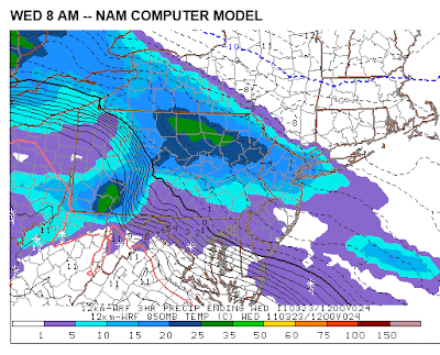
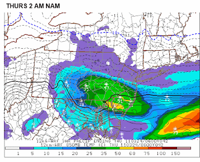
This looks to be an elevation dependent event as well -- meaning the higher up you are the better your odds for snow.   This could be a situation where some of the higher hills in Bucks and Montgomery County get an inch or so while lower elevations get rain during the morning round of the storm.   The heavier the precipitation is on the front end of the storm tomorrow the better the odds for some snow, especially north, as colder air aloft gets pulled down through the atmosphere.  

We should see a transition to rain from south to north -- with solely rain falling for a time in the Lehigh Valley and perhaps the southern parts of the Poconos.   This transition time could occur when precipitation may be lighter in intensity during the later afternoon hours -- could be drizzly in some spots as well.  The question then turns to Wednesday night, with the NAM (above) being the exception to the computer guidance consensus in showing a heavy swath of precipitation moving through that could lead to a transition of rain to snow even down into Philadelphia.  Again, the NAM is an exception...with the GFS and Euro not showing this heavy swath of precipitation at all.

Precipitation totals should average out to no more than an inch in many locations -- the highest will be north of the city where it could be more snow than not -- with a half to three-quarters common across the immediate city and suburbs, less than that south.


Regarding snowfall, our projected totals are elevation dependent but we think the best chances for heaviest snows are over the higher elevations of the Poconos.  I can see 3-6" of snow across there and Northeastern Pennsylvania.  Across the Lehigh Valley, 1-3" looks like a reasonable bet.  An inch is possible across the upper parts of Bucks and Montgomery Counties, perhaps even into Chester County's higher elevations.     Snow/sleet mix can't be ruled out into Philadelphia at the start of the event...and if the NAM is correct, it may end as that as well.

We'll provide another update on the storm tomorrow morning.

March 23rd, 2011 Forecast

Tonight: Increasing and thickening clouds. A mixed bag of precipitation or snow will move into the city after 2 AM. Lows will drop to around 32 degrees in the northwest suburbs and to around 37 degrees in Philadelphia. Winds will be out of the north-northeast at 5 to 10 mph. The chance of precipitation is about 90 percent. The sunset tonight is at 7:15 PM.

Wednesday: Snow or a mixed bag of precipitation will change to plain rain as temperatures rise into the lower 40s. Mainly snow will fall north of I-78 and in the Poconos as temperatures hold in the mid-30s up there. It will be a downright chilly and raw day on Wednesday. Winds will be out of the east at 5 to 15 mph. The chance of precipitation is near 100 percent.

Thursday: There is a 40 percent chance of a leftover snow or rain shower. Otherwise, look for a mix of sun and clouds and a gusty breeze out of the north-northwest. The high will be near 47 degrees.

Friday: Bright sun, cool, and the north to northwest breeze continues. The high will be near 46 degrees.

Wednesday Planner

7 AM 39 degrees, Snow / Mix

Noon 40 degrees, Rain

5 PM High near 42 degrees, Rain

Sunrise 7:00 AM
Sunset 7:16 PM


Coming Up Later: Tom will have an update on tonight's and Wednesday's snow / mix / rain event.

Changes are coming....

After 70s yesterday, the Piedmont will see low to mid 80s today and tomorrow. Enjoy!

A cold front will near the region by late tomorrow, and the chance of at least some scattered showers and storms will spread in from west to east by late afternoon then through the evening. Some of the storms could be strong to severe, and we will watch the storms closely. The probabilities from the SPC are actually fairly high in the Day 2 outlook, and if those probabilities hold, somebody, especially around the Ohio Valley, could be in a moderate risk in the Day 1 outlook for tomorrow.

Pattern change...

We are on the cusp of a pattern change....changing to a cool, wetter pattern. Highs in many places Thursday and Friday will be in the 60s, and then we get to the weekend. It is still a fairly chaotic situation to try and figure out the details, but we will likely see one system move through Saturday and Saturday night, and another one from late Monday into Tuesday. But the timing is still very much in question.

Both systems looks like pretty good rain producers, and both could have some degree of cold air damming in the favored CAD areas. In fact, if the European is right, some places would be doing good to see mid to upper 40s Tuesday.


It May Be Spring, But...

 The calendar and meteorology both say it's "Spring" by definition -- in fact in a meteorological sense it's been Spring for over 20 days.   However, Mother Nature and Old Man Winter don't care to agree with such silly wishes of warmth from most of the masses and wants to send a plethora of precipitation types into the region tomorrow.    Radar is already showing the first fingers of the storm system extending into West Virginia, with the main show of this storm back in Minnesota and Wisconsin.   Moisture that's streaming out east-southeast of the main low is in association with a frontal boundary that's slipping south along the East Coast and will play a huge factor in the storm's track, our temperature, and what ultimately falls from the sky.

This will not be an easy forecast -- the dreaded "nowcast" applies to this storm as temperatures at the surface will arguably make or break your precipitation type and one's forecast.   However, with temperatures poised to be colder to the north that at least some accumulating snow is likely from Montgomery and Bucks County on north, particularly the upper parts of the county.   I'm not so convinced that applies to the city...yet...but I do think it's pretty likely that the city does get some wet snowflakes mixing in.   It all comes down to timing and temperature with this event.   More on that in a minute.


Winter Storm Watches are out for the Lehigh Valley and Berks County on north -- the watches in the Poconos definitely make sense given the profile in temperatures is going to be cold enough for mostly frozen precipitation up there although one can't rule out some rain mixing in from time to time during the day on Wednesday up north.  The Lehigh Valley and Berks, in my opinion, are the "battle zone" where a colder solution such as the one the NAM is painting gives warning snowfall since little or no mixing at the surface occurs.  However, it is the only model painting that as the Euro and GFS both paint a mixed bag event where morning snow mixes and then changes to rain during the day as temperatures warm sufficiently above freezing in most locations.    The surface warming above freezing is the difference between a couple of inches of front-end snow and a six inch snowfall in the Lehigh Valley and even the upper parts of Bucks and Montco.

Farther south, the temperature profile battle as not as huge a deal but the NAM's depiction on temperatures would suggest some snow down into the immediate city on the front end before temperatures moderate enough aloft to turn the city back to rain, whereas the GFS and Euro are more of a mix to rain scenario.

The other concern is how this system wraps up on Wednesday night.  The NAM is suggesting a changeover back to snow in the suburbs, Philly, and even parts of South Jersey but again, it's the only model showing this changeover as the GFS and Euro both wrap precipitation up in the region before temperatures begin to cool off.   It's something to keep an eye on at this point.

Even if it doesn't snow at all in the city, the temperatures won't be all that high and the rain will be rather chilly.  

We'll have a snowfall forecast out this evening for the storm system and we'll update the storm as it moves through during Wednesday.