Senin, 31 Januari 2011

Monday Morning 1-31

Hey everybody, my first attempt at the blog post here so let's see how it goes. It's an honor to be asked by Matthew to keep up the blog while he's taking vacation so hopefully this goes ok. I'll let my buddy Andy handle most of the localized stuff for the Carolina area there since he's more familiar with how things work up there.

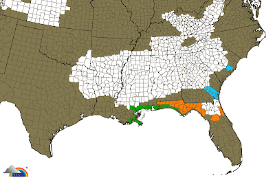
Ok let's talk about what we have to start off the week here. A huge storm system will be getting organized through today and tomorrow that will affect a good portion if not all of the country east of the Rockies over the next couple of days. Check out the warnings thumbnail that Matt has on the left side of the screen and you'll notice basically everybody northeast of Texas is under some sort of winter storm watch or warning.

The culprit for this? A big trough digging into the western half of the country as we speak. By later today and tonight a very strong area of low pressure will develop in Texas and lift northeast into the boot heel of Missouri by tomorrow evening. We are talking sub 1000 mb pressure with this low . . . which is not rare for a nor-easter but is not as common for the central US. Take a look at this . . .


I hope that worked right if not I'll try it again. That's a look at the GFS model for tomorrow evening. You can see the massive low in southeastern Missouri. Lots of cold air pouring in behind it with a lot of warm moist air out ahead of it.

What does it all mean? Well, a big time snow storm basically anywhere north and west of that low. Several places in the midwest could see 5-10 inches. South of that low is where you have the cold front. It will produce heavy rain from the gulf coast up towards the mid atlantic, and potentially some severe weather along the front tomorrow as well.

Note that this system is much farther north and west than the previous few that have brought snow to the Carolinas and much of the south. So this looks like a rain maker for everyone in the region. We'll keep an eye on this for the next couple of days.

Hope this worked ok for everybody. Will love to see any thoughts you may have or any questions about this storm. Have a great day!

Minggu, 30 Januari 2011

Sunday....

What a terrific day around the region yesterday! I love cold and winter weather as much as anybody, but it sure was nice to get to enjoy that type of day. And today will really still be very nice as well. Some clouds will creep in with time, but most Piedmont highs should still be in the low to mid 60s.

The forecast for this week is still a pretty complex one. A huge storm system will impact a large portion of the US...here in our region, the biggest impacts look to be Tuesday night into Wednesday.

A big arctic high will spill into the Plains this week and try to gradually bleed southward. This could wind up being a big snowstorm from the TX Panhandle through parts of OK, KS, MO, IA, IL, IN, WI, OH, MI, and into parts of the New England states. Somewhere just south of the snow area, some significant icing could still occur.

Around the Carolinas, this looks like a rain event...maybe even a few thunderstorms, but instability will be non-existent or extremely lacking.

Later in the week, another wave of energy could move along the front, which will be south of most of the region at that point. Need to keep an eye on that to see how it behaves.

I will be off this upcoming week. However, a couple of very talented meteorologists are going to be kind enough to keep some fresh content going here on the blog through the week.

First of all, Andy Wood is going to post some thoughts this week. Andy has been kind enough to post up some great content before...he always has some great stuff to say. Andy is a meteorologist at Fox Carolina in Greenville-Spartanburg.


Also, Hank Allen is going to post this week. Hank is the morning meteorologist at WGNO-TV, the ABC affiliate in New Orleans. I have mentioned him (and posted his thoughts) before here on the blog, especially back during the Gulf oil situation. Hank might even get inspired enough to do a video this week.


Both of these guys are good friends of mine, and both are skilled meteorologists. Both have spent some time in other parts of the country before settling in the past several years at their current locations.

I really, really appreciate both of them being willing to provide some great content while I am off. I am sure you will enjoy reading their thoughts this week.

Jumat, 28 Januari 2011

Milder weather for a couple of days....unsettled next week

Here is today's edition of the Carolina Weather Video. A nice weekend ahead, and I spend a good bit of time discussing the possibilities next week.


25 years ago.....the Challenger disaster. Those videos and images still send a chill up my spine. Even during childhood, I have had a love for all things weather, space, and aviation. I was very interested in the space program, and I kept up with every shuttle mission. I remember my mom and I watching coverage of the disaster in our kitchen....totally shook my young little world. For whatever reason, that was an event that deeply impacted me.....took me a long time to get over.

Weather played a role in the disaster....if you are interested in it, there are plenty of things on the web to read to see what role it might have played.


On to the weather...clouds this morning.....even a flurry or two can't be ruled out....as we catch the tail end of a clipper. Behind the system, we should see a lot of afternoon sun with highs in the low to mid 50s.

A great weather day is on tap for tomorrow with highs in the mid to upper 50s and lots of sun. I still think a couple of lucky spots might hit 60.

Clouds roll in Sunday, and highs will likely be a few degrees cooler.

Next week...

Lots of moving pieces impacting next week's weather. It appears a pretty strong cold air damming set up will unfold from later Monday through Tuesday. At the same time, some weak disturbances will ripple through....so some light precip is possible Monday and Tuesday.

The core of the main system will likely move through around Wednesday. It looks, as of now, as it the main surface low will head up near or maybe even west of the mountains, so the wedge should scour out with time. I am thinking we should end up with mostly rain Wednesday, but we will have to see exactly how the cold air damming sets up.

West of the mountains....you always have to keep a watch of that shallow arctic air. This is the real deal in terms of cold air moving into the Plains early next week, and as I discussed previously, that cold air will bleed southward with time, getting increasingly shallow as it does. So somewhere in there, you have to watch for ice potential....but where or when is still a mystery.


Kamis, 27 Januari 2011

Sunshine returns...

Take a look at today's edition of the Carolina Weather Video. Lots to talk about.....some milder weather through the weekend, then I spend a lot of time on our system next week. Plus, a peek deeper into February....


What an impressive storm system the most recent one turned in to! We had anything from lightning and thunder to rain, sleet, and snow across our region, but the heavy, wet snow really got cranking from the mountains up through the Virginias into southern New England. Thundersleet and thundersnow hit right before the evening commute in D.C., and the result was a disastrous go of it.

Many spots from DC up through SE PA, MD, CT, RI, into New York City and MA picked up over 15" of snow. And this was heavy, wet, caking snow....over 500,000 power outages at one point!

Around here, the weather will be pretty docile the next few days, and we will actually squeeze in a little period of milder temps tomorrow through the weekend. Highs Saturday will surge well up into the 50s with lots of sun.

Next week...

As of the morning model runs, the Euro actually bowed to the more suppressed solutions on some of the other modeling with the track of the system next week. Taken verbatim, the Euro, GFS, and Canadian all show some wintry precip to some degree across portions of the region.

I am not sold as of yet. However, will say that another blast of true arctic air looks to plunge into the nation's midsection early in the week, and that arctic air will bleed southward and will get increasingly shallow as it moves.

As several pieces of energy eject from the western US, there are lots of possibilities on the table for how things might work out.....stay tuned. The latest Euro had a much higher-amplitude ridge near the west coast, and that caused our system to take a more southerly track with its 0z run. We will see how future runs unfold.

Rabu, 26 Januari 2011

Upper air low moving through...

Here is today's edition of the Carolina Weather Video. I talk about our current system, where the snow will occur, and where we go from here....


Running way behind this morning, but no major changes to the overall ideas. You can see my map below. I think some wet snowflakes are possible really anywhere across the Piedmont, with the best chance from I-40 and points north.

I do still think some slushy accumulations could occur in the northern foothills and Virginia border counties as we head through this afternoon, and I think parts of the mountains will get a really good thumping out of this. Many mountain spots had already kicked over to snow as of 9am, and they were still in the southerly flow part of the system!

As the colder air aloft moves in, that is when the potential for snow will spread in. I also enjoyed seeing a few storms around this morning! Great stuff....

Below is my accumulation map...no overly significant changes from yesterday. You can see the strip of really significant accumulations will run from the mountains up into the Virginias and southern New England.

Selasa, 25 Januari 2011

System finally pulling in...

Take a look at today's video, docked below. I take a look at our incoming system and the week ahead...


It seems I have been talking about this system forever. It is finally arriving today, and rain, which began the day covering much of the Deep South and Tennessee Valley, will spread into the Carolinas as today unfolds. The man surface low will track from near the Gulf coast to just inland from the Carolina coast later tomorrow.

Periods of rain will occur across the Piedmont tonight into tomorrow morning. Total rain amounts are looking a little disappointing in some areas, but hopefully at least some folks will get a good soaking out of this....we could use it.

The upper level low (ULL), which is sitting over Texas this morning, will strengthen as it moves though Mississippi into Alabama and the Carolinas. There has been a little northward shift in the track of this ULL, and it is looking like the strip of pretty good accumulating snow is going to wind up being in the northern half of the outlined area I posted yesterday afternoon. Below is the snow map I am going with this morning.
Really anybody in the Piedmont is fair game to see some wet snowflakes as tomorrow unfolds, but the strip of significant accumulation potential will run from north MS and western TN east-northeast through Tennessee and into parts of KY the Virginias. I would include northwest NC in this area as well....mainly the northwest mountains and possibly parts of the northernmost foothills.

These outlines are general, and there may be further shifting needed as we see where the band of heavier precip actually sets up.

The weather looks pretty quiet then for the rest of the week into the weekend. Another system will swing through Friday, but it looks fairly insignificant as of now. The weekend is actually looking pretty nice.....maybe some 50s for highs.

There is still the chance of a storm system early next week, and February still looks cold as it gets going. I will delve more into that in the videos and discussions later this week.

Senin, 24 Januari 2011

Upper level low thoughts


Just to make sure I am clear, because I don't know that I was overly so in my morning post. I feel fairly confident that there will be a strip of snow tied directly to the path of the upper level low behind the surface system.

The possibility of this accumulating snow will likely begin in north Mississippi tomorrow night and make it into North Carolina by Wednesday evening.

This is one of those deals where we are looking at a deformation band, a relatively narrow area on the northwest side of the upper air low. In this band, precip could be heavy, and dynamic cooling (cooling from aloft) will take place and allow for snow. But this will likely only be at most 75 to 100 miles wide, and could be anywhere in the area outlined below.

Only that 75-100 mile wide area will likely have the chance of accumulating snow...if you are not in that precise area (as obviously many in the outlined area will not be), you will not see much snow. But I have outlined the zone within which it is most likely to set up.

Upper level lows always contain surprises, thus it is the 'weatherman's woe.' As for amounts, a little early for that....I could easily envision a few spots within that band getting over 5 or 6" with most amounts less than that.

Looking like mainly rain....but some wet snow possible on the back end

Here is today's edition of the Carolina Weather Video. Lots of time focusing on our next system....give it a look.


First off....a little light snow is making its way through the region this morning. It was even enough to whiten the ground in a few spots.

Highs will be in the 40s today and tomorrow....even a few lower 50s possible in a few places tomorrow, which leads us to....

Our next system...

The low pressure area will generally take a favorable track for interior Carolina snows. However, it looks like for a good portion of the storm (outside of the mountains), the lowest 3000 to 5000 feet of the atmosphere will be a little too warm for snow.

So, I anticipate rain developing in tomorrow afternoon (could be a bit of sleet mixed in very briefly due to some dry air aloft), and the rain will continue at times tomorrow night into Wednesday morning. But, there is still some snow potential with the system....see below.

Cold core upper air low....weatherman's woe....

A cold core upper air low will trail just behind and northwest of the main surface low. One of the main features of an upper air low is very cold air aloft. Time and time again, I have seen these systems put down snow, even when not even remotely foretasted to do so by modeling.

So, I think the potential for a period of wet snow is still very much there from north and central Mississippi, north Alabama, parts of Tennessee, northeast Georgia, the Upstate of South Carolina, then into the foothills and Piedmont of North Carolina.

For North Carolina, the best chance for this period of wet snow will be Wednesday afternoon into Wednesday evening.

You really have to watch those upper level lows for surprises. It is quite possible that some areas within the corridor I described above could see a period of heavy snow with multiple inch per hour accumulation rates, but that would be in a limited area, and could be anywhere along the track of the low.

But that snow potential is entirely dependent on dynamic cooling....in other words, cold air brought down from aloft due to heavy precip. This snow potential is tied directly to the upper air low track, and it is a deal where if you are just north or just south of the track, you wind up with some rain while spots right under it get snow.

At any rate, that's the basic idea. Some good rains look possible from later tomorrow into Wednesday morning, then we will see how the potential for some back side snow works out for somebody in the region.

Minggu, 23 Januari 2011

Well well....

This will be fairly brief, but I wanted to put something up this morning.

The various models continue to really struggle with the precise track the upper air and surface features will take for our upcoming storm system....with the exception really of the Euro. It has been fairly consistent.

I really have no changes to the overall track ideas I have had out there as most likely....and that is a track very near the Carolina coast, give or take 50 miles.

The 0z GFS had that track, and then the 6z GFS came in and was further out to sea....and never brought a flake to the new England states! I will continue to give that model essentially no weighting until it shows an ounce of consistency.

The UKMET is way inland with the track, and the 0z Canadian is inland as well. While that track is possible, the track closer to the coast, as generally the Euro has had, is the way I still lean.

I have kind of been of the opinion all along that if we get a strong, strengthening low riding right up along the coast, the temperature profiles would sort of take care of themselves in the favored areas where the deformation band sets up (northwest side of the low where the heaviest precip occurs).

However, let's take the 0z Euro. Despite a near perfect track to get good snows from north Georgia up the I-85 corridor through SC and NC and back into the foothills and mountains, the lower level thermal profiles remain warmer than I would like to see for snow once outside of the higher elevations. This despite, in NC at least, the surface winds being out of the north for all or most of the storm.

I still have a hard time believing that, if the system unfolds as the Euro shows, that a lot of the deformation band precip would not be able to kick over to snow. I know there is no fresh source of cold air and no high to the north to funnel in low level cold air.

But if the 500mb map does indeed wind up looking like this (see image below), the height falls are so strong, I would imagine heavy precip rates would be able to overcome less than optimal low level temps.
But hey, the model has been pretty insistent that the low levels really do not cool enough for snow once you are out of the mountains and parts of the foothills. So maybe it is right. It definitely, definitely could be.

Bottom line here....lots and lots of details still to iron out. Folks in the I-95 corridor, this was never really your storm it appeared from the get go...I had always been leaning to the areas from I-85 and points north and west. In those areas, I will just say the rain scenario may win out, but I just don't have a lot of confidence in saying it is a rain storm and that is that...so let's see how things play out over the next 36 hours.

Sabtu, 22 Januari 2011

Saturday morning...

Well, the GFS continues to struggle, but the is nearly unanimous agreement amongst the other major models that a low will develop and move from the northern Gulf of Mexico and the strengthen as it moves up close to the Carolina coast. There are some differences in intensity and exact placement of the low, as you would anticipate a few days out, but really, if you discount the GFS, the agreement is pretty good.

The models that had taken a more inland track for the low yesterday, such as the Canadian and UKMET, have made a shift east to a track right near the coast. The Euro track on its 0z run is very close to, maybe slightly east, of its tracks the previous couple of runs.

In terms of ensembles, the Euro ensemble mean is pretty close to the operational track. The Canadian ensemble mean is a little east of the operational.

Here is the point where I will, as in previous systems, caution you not to pay tons of attention to QPF (precip) amounts. Suffice to say the 0z Euro is showing a major winter storm from northern Alabama and Tennessee east into northern Georgia, the Upstate of South Carolina, western North Carolina near and points north and west of I-85, western Virginia, and up into interios New England. The Canadian result is much the same.

The reason the GFS is different than the other modeling all has to so with the piece of upper level energy diving into the Lower 48 from Canada by later tomorrow. It brings the energy into the country around eastern Montana into the Dakotas, while the Euro is a decent bit west of that. The result is a stronger, deeper system on the other models compared to the GFS.

I will note that the Euro is farther east with this energy entering from Canada that it was on its 12z run yesterday. Don't know if that is a trend or the modeling just simply adjusting to the correct idea. That is the key to watch for this system.

So, no changes from me. The players are still on the field for a potential significant winter storm for parts of the Southeast. And for the Carolinas, I would still favor areas near and north and west of I-85.

Now is still not the time for towel throwing or celebrations. This piece of energy is coming in from a very data sparse area, so some adjustments are likely on the modeling. So, this could trend into a much weaker, less significant system, or it could remain a pretty powerful system. The devil is in the details, and those details will remain fuzzy for a little while longer.


Jumat, 21 Januari 2011

Friday evening...

Not a whole lot to add to the thoughts I put out there this morning. Since the 6z run today, the GFS has lost tis way it seems. It seems to be digging the upper level energy in way too far east, resulting in a slower-to-strengthen system that most other modeling. So, I would not pay a lot of attention to the 12z and 18z GFS as of now.

I would still lean the way of something similar to the Euro. It has been the superior model this cold weather season, and it also has the general support of most other modeling in terms of a much more powerful system than the GFS is indicating.

Lots of variables are still up in the air, so again, it is way too early to count your snowflakes or raindrops before they fall.

Just wanted to throw out there that the potential for a big-ticket item for parts of the region is in play...and I would still lean toward the areas from roughly I-85 on north and west.

Arcitc air back in place....potential big system next week....

Take a look at today's video...I step you through some of the modeling and give you some thoughts on what could be a major eastern US storm system next week....


Colder air has again arrived....and we will be generally quiet and chilly all weekend.

I will skip right ahead to the system next week. Most of the models have converged on a solution that consolidates the upper level energy into a powerful upper level low that develops roughly over the Ozarks and winds up overhead in the Carolinas. This results in a phasing, rapidly deepening low pressure that tracks from the northeastern Gulf of Mexico to near or just inland of the Carolina coast and finally up to the New England states.

Now, I will caution here that, like some of our previous systems, we are talking about the precise interactions of upper level features in this fairly chaotic pattern, and some changes are quite likely.

But as it stands now, I would lean toward an idea something similar to what the GFS and Euro modeling is showing. What precip types any individual location would receive would depend entirely on the track and intensity of the surface low. For many Piedmont areas, this could be a snow to rain then back to snow scenario. But these details are really not even worth getting in to at this point.

So we will see what happens. If the energy aloft stays consolidated, then a major system is quite possible. If the system deepens too soon, many in our region could get a driving rain storm. If it deepens and tracks just right, it could be a biggie for somebody in the region.

But please hear this...the solutions that the Euro and GFS have shown this morning are rare events and very difficult to come by. So, I would not be surprised at all to see this intense solution not verify.

Like I said yesterday, I will likely not have any real confidence until a couple more days pass. Lots of players on the field here. As I said in the comment section, now is not the time for celebrations or pity parties. Lots will likely change in coming days.

Kamis, 20 Januari 2011

Cold set to return....winter storm possibility early next week?

Below is today's edition of the Carolina Weather Video. Again this morning, lots of ground covered....give it a look.


Today will be at least 10 degrees cooler than yesterday for most in the region with Piedmont highs in the 40s to near 50. Snow will fly in Little Rock, Memphis, and Nashville today, but the mountains will chew up most of what little moisture is left with that system as it arrives in the region. So, maybe a passing sprinkle or flurry tonight, but that's about it. The mountains will pick up several inches.

Tomorrow will be a cold, blustery day with highs shy of 40 in many Piedmont spots. Factor in winds gusting to 25 or 30mph, and it will be a brisk day.

It will stay pretty cold through the weekend with 30s for highs Saturday and lows in the lower 20s and upper teens.

Possible winter storm...

I still think all of the necessary players are on the field for the possibility of a winter storm for parts of the region early next week. Anytime from Monday afternoon through Tuesday is fair game at this point.

I won't bore you with all of the model details, but almost every model is indicating wintry weather in some shape, form, or fashion with this in the favored cold air damming regions of NC, SC, into northeast GA.

I have really made no changes to the forecast overall....the chance is there for a mixed bag of wintry precip from later Monday through Tuesday, especially areas near and north and west of I-85.

There is lots of model uncertainty, and really, the models are handling the upper level energy quite differently than one another in many cases. So, there is large potential for adjustments as we go forward. Stay tuned...

Rabu, 19 Januari 2011

Interesting times ahead...

I cover a lot of ground in today's edition of the Carolina Weather Video. Anything from a nice afternoon today, some Tennessee Valley snow later this week, more arctic air over the weekend, winter weather possibilities in the Carolinas early next week, and the pattern as we march toward February. Give it a look....


We began our Wednesday with lots of fog and clouds, but this should actually wind up being one of the nicer afternoons we have had thus far this winter. Highs will top out in the 50s, and we will see lots of afternoon sun.

This is a quick-hitting pattern, and this mild weather will not stick around. A low pressure area and its associated arctic cold front will move through the Carolinas Thursday night. East of the mountains, any precip (and that will be limited) will be in the form of rain. To the west, this will likely be a light snow event through the Tennessee Valley. The amount of precip is limited though, so don't look for huge snow totals.

Much colder air will again flow in here Friday, and we might see some Piedmont spots struggle to hit 40 Friday afternoon. Snow will be flying again Friday morning in the mountains.

It will be cold for the weekend again with many spots in the 30s for highs Saturday and low to mid 40s at best Sunday. Lows will drop into the lower 20s and upper teens.

System early next week...

We are dealing with lots of moving pieces here, but this sure has the overall look of one of our cold air damming winter weather events. Frankly, at this point, the European, Canadian, and UKMET models are all really in quite good agreement with one another. The GFS is a little slower and weaker overall. But just look at this panel from the UKMET....1039mb high near the NE, and a low in the northern Gulf. That always smells like trouble.
To me this has the looks and feel of a potential ice event across parts of the region....maybe a snow to ice deal in the NC favored damming regions.

Keep in mind we are firmly entrenched into the 'potential' category here.....this could vanish in future model runs as, like I mentioned, we are dealing with lots of moving pieces. But it has my attention.

Selasa, 18 Januari 2011

Changeable weather....

Below is today's edition of the Carolina Weather Video....


After some residual icing issues on some roads in the region (mainly the Triad, northern foothills and mountains), we will warm significantly today with most Piedmont highs in the upper 40s to even some lower 50s.

Simply put, tomorrow will be one of the nicer days we have seen this winter season. You won't find anybody that loves cold weather and snow more than me, but tomorrow will be nice....soem 50s for highs and lots of sun.

Don't get used to it....the 'warmth' will not last long. Our next system, really a cold front, will pass through Thursday night into Friday morning and bring some Piedmont rain chances with it. Behind that front, pure arctic air will again plunge into the entire region, and many of us will not get out of the 30s for highs Friday and Saturday. Lows will likely wind up in the teens again Saturday and/or Sunday morning.

I also should note that the European model continues to pop a coastal low later Saturday that throws some snow into the eastern Carolinas....generally east of I-95. We will see if those trends hold.

Next week...

I am watching with interest another potential system Monday into Tuesday next week. That one has some wintry weather possibilities somewhere around the region.

Longer term...

The PNA index (Pacific-North America) looks to stay positive basically through the rest of the month, generally meaning a ridge in western North America. So I still see no sign of a prolonged warm-up anytime soon.

Senin, 17 Januari 2011

Next system heading in...

Here is today's edition of the Carolina Weather Video. Couple of systems this week.


I hope everybody had a great weekend. After not taking a day 'off' from closely watching the weather for over a month, I tried my best to take a step back over the weekend. I love my job, and it is such a privilege to this for a living. However, I needed to back away for a bit just to refresh my mind. But I couldn't resist completely....kept taking a peek at a couple of things yesterday, especially the end of this week.

More on that in a second....let's talk about today and tonight. An area of low pressure is getting its act together in the northeastern Gulf of Mexico this morning. Rain is widespread through the Florida panhandle into southern Georgia, and that area of rain will lift north into the Carolinas later today and tonight.

I anticipate some light rain making it into the Piedmont later this afternoon, but the bulk of the heavier rain will be this evening. We are in a cold air damming regime, so highs will struggle to make it into the lower 40s around the Triad....maybe some mid 40s around Charlotte and the Triangle.

This evening, locations in the foothills could see temps dip to near or just below freezing, meaning a period of freezing rain is possible. However, if that does occur, at this point I only anticipate some relatively minor icing on elevated surfaces, and this would mainly be in the northern foothills.

Up in the mountains, a period of snow is quite possible, and some areas might wind up with at least several inches depending on whether or not heavier precip can make it in there.

System later in the week....

I will discuss this in the video, but the modeling has taken a shift. Earlier model runs were indicating colder air arriving, followed then by another southern branch system that spread winter weather possibilities through the Tennessee Valley and upper Southeast. However, the models at this point have generally shifted to showing the entire kit and kaboodle coming through at generally the same time (Thursday night into Friday) instead of cold air first, then the southern branch system. I show why this is the case on the video.

So, for the time being, the threat of winter weather later this week in non-mountains areas of the Carolinas has diminished. However, if the southern branch feature can remain some separation from the main upper tough coming through, then that possibility would increase again. We will watch and see.

By the way, looks cold again behind this for the upcoming weekend.

Jumat, 14 Januari 2011

Milder for the weekend...next system on the horizon...

Here is today's edition of the Carolina Weather Video. I talk about the next week's worth of weather, and why the GFS is likely wrong next week.


What a frigid start to our Friday. Most Piedmont spots were in the teens, and many mountains spots were in the single digits. In fact, several spots in north Alabama were in the single digits. Brutal!

Temps will moderate over the coming weekend with Piedmont highs in the 40s....maybe even around 50 in some spots Sunday.

System next week...

In today's video, I showed you why I thought the 0z run of the GFS was way wrong with its handling of things next week. The 6z has stepped in the direction of the Euro and Canadian with much more emphasis on the coastal system, and a colder CAD scenario.

The bottom line here is that at least a brief period of wintry precip is possible in the favored CAD areas, especially the foothills. It seems to be that the quicker precip gets into the region, the higher the chances will be for any wintry precip.

The Euro quickly changes almost everybody over to rain as it blasts the low up the coastal plain. At this point, it doesn't look like a huge problem with wintry precip, but often times the trend is colder in CAD scenarios, so we will see.

And, don't look now, but there are signs of another system around 9-10 days from now.

The basic idea is the same general pattern looks to continue for the foreseeable future.

Kamis, 13 Januari 2011

Still in the deep freeze...

Here is today's edition of the video. I take a look at what's ahead as we go through the remainder of January.


Check out this shot from Charlie's Beech cam up in Beech Mountain, NC. Looks like something from the arctic tundra...


Cold air remains in place for the next couple of days. Piedmont highs will be in the 30s today with upper 30s to around 40 tomorrow. Tonight should be the coldest night of this cold blast for most....lots of teens in the Piedmont.

Milder conditions will return for the weekend with 40s for highs Saturday and Sunday...maybe even a few folks clipping 50 Sunday.

Our next system will roll in by later Monday into Tuesday. I think the GFS is likely lost once again (losing the southern stream feature), and a solution more similar to the Euro and Canadian is the way to go. If that is the case, there will likely be some fairly healthy cold air damming as the system arrives (even though the parent NE high is not particularly strong), so I suppose at least a brief bit of wintry precip is possible in the favored CAD areas as the precip initially moves in.

But aside from the higher elevations, I am still leaning toward a mainly liquid system. But we will keep an eye on the CAD.

Overall, most indicators continue to point toward more cold air as January unfolds. I see no sign of any prolonged above average temps anytime soon.

Rabu, 12 Januari 2011

Arctic air in place...

Here is today's edition of the Carolina Weather Video. Give it a look. I take a look at the good, bad, and ugly with my ideas for the last winter storm. I always want to show what went right and what went wrong with the forecast and see what we can learn from it. I also look at another big snow event in the mountains and the New England states, plus we look at the pattern ahead as we get deeper into January.


Please see the video for a run-down of the good and bad with my forecasts leading up to our latest winter storm. Many of the overall ideas were good....snow, ending as a period of freezing rain with a glazing of ice on top of the snow. The heavier totals, as forecast, were from the southern Piedmont into the Upstate of SC and north Georgia, with amounts tapering off the farther north and east you went. The Triad did eventually get into the 1-2" category for snow accums, while the northern foothills eventually eclipsed 2" in most areas. The Triangle got very little snow, but I always had verbalized the Triangle as being right on the line for precip types. I was way underdone on snow totals in the Sandhills over to the southeast coast of NC....they did quite well! And certainly the Triad verified on the lower end of or below the ranges I listed.

As I mentioned in the video, the modeling that ramped up the QPF to over 1" in the southern Piedmont wound up being way overdone. Looks like CLT wound up with about 0.5" liquid equivalent....around 0.75" for GSP and around 0.25" for GSO.

So, in future systems, I will be skeptical when I see the NAM or the hi-res WRF rapidly ramp up QPF within 24 hours of an event.

Going forward....

Another huge upslope event for the NC mountains continues today. Some areas will likely wind up exceeding a foot of new snow once again. What a winter the mountains are having!

And our low pressure has bombed into a huge winter storm for the Northeast. Some places in New England will again exceed two feet!

We stay in the deep freeze through the end of the work week with 30s for Piedmont highs and some teens for lows. We should see lots of sun though, so the roads that are not shaded should really improve.

Next system....

I am watching the next system...probably late Monday into Tuesday. There is a pronounced cold air damming signature with that one, so I guess I can't rule out a little wintry precip in the favored CAD areas at onset. But at the moment, this still looks like a mostly liquid event for the lower elevations.

Selasa, 11 Januari 2011

Tuesday....

Well, the snow finally did make it into the Triad and Triangle regions, although many amounts were on the light side. When the detailed snow maps are out, we will take a look at the good, bad, and ugly and see what we can learn from this system.

Speaking of maps, here is the model-derived precip totals from the Raleigh NWS. The normal, more accurate maps will probably be out tomorrow.


Many areas wound up with significant freezing rain yesterday evening into last night, and the freezing mist continued this morning. Most spots across the Piedmont have a layer of ice on top of all surfaces, except the DoT crews have done a fantastic job getting the main roads drivable.

It is going to remain cold all work week long with 30s for highs and 10s for lows. I think it is within the realm of possibility a few spots in the Piedmont could see single digits for lows Friday morning.

Temps will moderate this weekend with 40s returning for highs.

The next system swings in early next week. At this point, I am leaning toward that one being of the liquid variety, but I have frankly spent very little time analyzing that one to this point.

I want to thank each and every one of you for stopping by the blog. It is incredibly humbling that you folks would care to know what I have to say. I greatly appreciate it! Let's keep watching the weather together!

Senin, 10 Januari 2011

Monday evening....

The southern Piedmont has switched over to a mixture of sleet and freezing rain in many instances. All surfaces around the Charlotte metro are frankly turning into a sheet of ice. I would strongly, strongly advise not heading out tonight or tomorrow morning.

For the folks that did not get the good snow amounts, I am sorry it worked out that way. That was the diciest area of the forecast, and you knew it was a matter of dry air vs. incoming snow.

All areas in the region are fair game for freezing rain and drizzle tonight into at least tomorrow morning. Again, I would strongly recommend staying in.

Late-morning....

Just finished hours of live television hits, so the mind is a bit mushy at the moment.

For the Triad and Triangle folks, this has been painful to watch, but not really unexpected. The air was extremely dry, and it takes a while to moisten that up. All along, you knew amounts would generally taper off as you went farther north and east. There appears to be a boundary aloft near the NC/SC line, and heavier precip has had a really tough time making it north of that.

With all of that said, the short-term models are adamant that the best lift (and therefore best snow chances) will not roll into central NC until this afternoon. So, I will let the accumulation map ride (what's the point in changing now anyway) and see how it pans out. As I mentioned in the comment section, the largest bust potential is probably in the northern foothills, but I would not completely throw the towel in yet. Let's let the system play out, and then we will see how good or bad everything went.

I am very happy for the folks in the Upstate and into the Charlotte metro that have done well thus far with this system. That area has received the short end of the stick seemingly countless times over the past few seasons, so I am happy those folks got a good snow.

All right, for those that are seeing the precip they want....congrats! For those that wind up short-changed.....we will try again next time.

What a fun winter season this has been thus far!

Winter storm underway...

Snow continues to develop into the region this morning. All in all, looks like things are behaving according to plan. As of 6am, many areas just west of Charlotte have already seen 3" with some 6" and 7" totals down in the Upstate.

Here is the call map I am using on air this morning. As always, there will be some localized variations.

In time today into tonight, drier air aloft will work in, and the result will be snow transitioning to sleet and then mainly freezing rain. Not a huge ice storm for the I-85 corridor, but a glazing of ice sure seems possible. Down into the midlands of SC, a quarter to maybe even a half inch of ice is possible on top of the snow.


Minggu, 09 Januari 2011

Call Map and discussion....

The winter weather event is underway for the Lower Mississippi Valley into MS and parts of AL. Not a whole lot of changes to the ideas down that way.....going to be a very significant winter storm. Areas from Birmingham south to Montgomery, and in MS, roughly between Hwy 82 down through and south of the I-20 corridor, icing is a big concern with significant freezing rain accumulations possible.

North of the freezing rain area, north MS, north AL, and much of Tennessee are in for a good snow event. Widespread 3-7" totals looks likely, and some areas in the Tennessee Valley could sail past the 8" mark. Same general idea for north Georgia, although the closer you get to Atlanta, the more tricky is gets.

For the Carolinas, the model precip output has been on a general upward trend today for many areas, especially the short-range mesoscale models. The last couple of NAM runs have printed out over 1" of liquid equivalent precip for the Charlotte metro and even more for the Upstate of SC. I have not gone this bullish yet, but it does make me pay attention.

Here is the call map for the Carolinas. Keep in mind that everybody, except possible the northern foothills, is fair game to see a transition to light freezing rain or freezing drizzle by Monday evening or night, and a glazing of ice is likely. These are snow accumulations on the map. In the area of highest ice concern, 0.25" to even 0.5" of ice is possible on top of some snow accumulation.

These are general ideas, and there will always be localized variations, even on a perfect forecast map. And don't take the exact lines drawn as absolute truth.....give it some wiggle room one way or another. Also keep in mind there will almost certainly be some higher totals than indicated in some mountain areas.

Bottom line is it looks like travel will gradually become difficult (if not impossible in many areas) from later tonight in SC and through the morning and day tomorrow in NC.


Sunday morning....

Good morning! Quick post before church this morning.

No huge changes, and you can see the initial accumulation ideas I put out last night in the post below this one.

All seems to be unfolding about as you would anticipate to this point. I will put out a call map this afternoon. Looks like a good snow event for parts of Arkansas, about the north half of MS, northern AL along and north of I-20, much of Tennessee, northern Georgia, and into the Upstate of SC and parts of western and southwestern NC. I will say that back in the Tennessee Valley, some 8+" amounts appear a possibility. The amounts get trickier as you get into further north into NC.

I will say that the idea of the second disturbance diving in in time to rejuvenate precip again toward Tuesday morning in parts of NC has some merit. Of course, that could be in the form of ice for many.

As always with winter weather events around here, this is a tough nut to crack.

Keep an eye on the Gulf of Mexico convection....if that races out ahead of the rest of the precip, that will cut down on precip amounts farther north. You need that line of storms to lag behind the main precip area, at least a bit.

More this afternoon...

Sabtu, 08 Januari 2011

Saturday evening...

Some quick thoughts this evening....

How about the Saints/ Seahawks game?

Some discrepancies continues with the modeling regarding precip amounts. But, I am going to lay out a few very preliminary accumulation ideas. Please be aware that significant adjustments might need to be made as we approach the event.

For the I-85 corridor from the Upstate of SC all of the way up to the junction with I-77. Snow should begin by Monday morning, and the atmosphere should support all snow for this area until early afternoon at the earliest. After that, the temps aloft warm a bit, and there would be a switch over to sleet and mainly freezing rain. For the GSP area, I will go 3-5" of snow with a glazing of ice after that. For CLT, I will go 2-4," then the glazing. Western areas of the CLT metro could be more toward the 3-5" area.

The Columbia area is a very tough call. There will be a period of snow, but the warming aloft will be quicker down in that area, and a transition to sleet and freezing rain will then occur. The freezing rain potential is much more significant in this area, and at least a quarter inch of ice is quite possible....maybe more.

For the I-40 corridor from GSO to RDU....very very tricky. Precip amounts are a huge question mark. I will go with 2-4" of snow, and then a tenth to maybe a quarter inch of ice in some areas.

Back to the west, this looks like a good snow event for north Mississippi, especially along and north of Hwy 82, and in Alabama north of I-20. Tennessee also looks to see a good snow as well, especially along and south of I-40. I would think a general 3-6" type of snow in many of those areas, and that should carry over into northern Georgia as well. Many spots in the Tennessee Valley area could verify toward the higher end of (or even exceed) that range. I am still quite concerned about the ice potential in central MS, AL, and GA, but precip amounts are a question mark as some modeling is shifting the best precip up into the Tennessee Valley.

Some general ideas as I see it this evening. Be aware some fairly significant adjustments are always possible.

We will see how things look as Sunday unfolds. Keep an eye on the RUC modeling over the next 24 hours, and as we get deeper into Sunday, it becomes increasingly NOWCASTing time....meaning watching radar trends and surface obs instead of models.

Saturday morning...

Some pretty big model fluctuations and differences continue in terms of amounts of precipitation with our approaching storm system. The 0z run of the GFS put out close to an inch of liquid equivalent precip near and just south and east of Charlotte while the 0z Euro and NAM were much, much less. The 6z GFS came in with about a quarter inch less than the 0z run. The 0z and 6z NAM held the 0.5" QPF line just south of Charlotte. (I just use Charlotte as a good singular point to reference the model differences.)

Winter storm watches are up for a lot of real estate. In the image below, all of the white counties from the Lower Mississippi Valley into the Carolinas are under winter storm watches.
My overall ideas have not changed. This should be a big winter storm for a good chunk of AR, MS, north AL, north Georgia, southern TN, and South Carolina. I feel like this will be a pretty significant event for at least southern NC, but the question marks get larger the farther north you go in NC due to uncertainty with precip amounts.

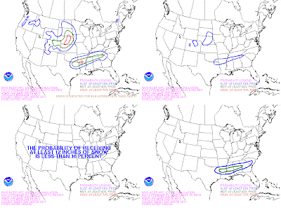
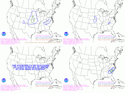
Below are the Day 2 and Day 3 winter weather maps issued this morning from the HPC.

Day 2
Day 3

Jumat, 07 Januari 2011

Friday afternoon.....

Some thoughts on the early week storm system. Below are two maps outlining my general thoughts on precip type areas. Keep in mind these boundaries are not hard and fast and might be adjusted. Also keep in mind I actually drew them up this morning. After reviewing the 12z data, I might tweak a spot or two, but the overall ideas remain the same.

This is seemingly always the range leading up to winter weather systems where lots of uncertainty seems to develop. I know seeing the QPF numbers continue to gradually wane, especially in NC, is extremely painful for snow fans to watch. I feel your pain. Generally speaking, there has been a trend in the modeling of weakening our southern branch feature every so slightly quicker than some of the previous runs.

Here is something of note....our disturbance is just as strong on the most recent run as it enters the Lower Mississippi Valley that it was on its run 24 hours ago. The quicker weakening takes place as it heads for the upper Southeast. I really think it is just a subtle difference in some energy over the New England states, but equally if not more important is the latest Euro is a little stronger with the next piece of energy in the Rockies.

Just comparing the Euro to the 12z run 24 hours ago, the difference in strength of the system as it enters the Southeast is small, but it is enough to cut the QPF numbers.

This is why I have been stressing, and continue to stress now, to not get wrapped up in QPF numbers. It is not good to get really excited or really down at this point about QPF, even still at this point.

Listen....the southern branch feature will definitely weaken as it approaches the Carolinas. It is a matter of how quickly it will weaken. That is the big question mark for Carolinas precip amounts.

Are the lower precip totals going to be a reality? Possibly, but possibly not. It is simply too soon to know.

This is really the point where I will just keep the forecast ship steady and true as we head into the weekend. I will not change the wording from my overall ideas that I have had out there. The potential for a widespread, significant winter storm from the Lower Mississippi Valley into the Carolinas is still very much there.

Will there be some disappointed people. Yes? Will there be some very happy snow fans? Yes.

Let's give it another 36 hours or so before anybody in the region (from Lower MS Valley to Carolinas) starts cliff-diving or starts the celebrations.

Two systems for the Carolinas...

Please give today's edition of the video a watch...I will step you through both today's system and the system early next week.


Two systems in the offing. One is later today and tonight....the other is the much talked about system for early next week.

First off, we basically have a strong clipper that is dropping into the region. I have just seen the 12z NAM, and it is sticking to the idea of painting a very narrow stripe of accumulating snow across the region. This will likely be a strip of accumulating snow only about 50-100 miles across, and it will run in a west to east fashion. Honestly, anywhere from the Hwy 74 corridor to the I-40 is fair game to have this strip set up over you, but right now I would lean more toward the general area around Hwy 64. That is subject to change though. Wherever that strip does set up, a general 1-2" snow could occur. However, if the instability and forcing that the NAM shows does indeed materialize, a few very localized spots might see 3" or 4".

But I can't stress this enough...this will be a narrow and, and many will not see any accumulation at all. The best chance of accumulating snow will be from very late this afternoon through this evening.

System next week....

I don't really have any changes here. Some of the modeling on some runs has backed off a bit on the total precip amounts as the system moves into the Carolinas. That could indeed be the case, but overall I haven't seen a whole lot to lean me away from the idea that this looks like a widespread, high-impact type winter storm for a lot of areas from the Lower Mississippi Valley into the Carolinas.

A little later today, I will post a couple of maps showing the general precip type areas I am going with as of now. Generally speaking, this looks like mainly snow for AR, north MS and AL, TN, north GA, northwestern SC, and much of NC from roughly the I-85 corridor north and west. South and east of that line, there will be an icy mix, and there could be a significant ice event in parts of central MS, AL, GA, and SC.

Again, check back a little later today and I will post some precip type maps.....


Kamis, 06 Januari 2011

Thursday late afternoon...

After reviewing the latest data through the day, including the entire 12z suite of guidance as well as the 18z NAM, I have seen nothing at all to change the overall concept I have had out there. The bottom line is this....the potential is there for a significant winter storm all of the way from the Red River Valley early Sunday to Arkansas, northern Louisiana, northern and even central Mississippi and Alabama, Tennessee, north Georgia, much of North Carolina, and northern and central South Carolina.

I am growing more and more concerned with the ice potential for areas in central Mississippi, Alabama, Georgia and into central parts of South Carolina. The ingredients are there for a big ice storm in at least parts of those areas. Winds will remain out of the northeast through the duration of the event. Those winds will continue to advect in cold, shallow arctic air. Hopefully for those areas near this zone, either periods of snow or sleet will help to cut down on freezing rain amounts....because if all of the precip were to fall in those areas as freezing rain.....yikes.

North of the icing area is the mainly and all snow area. Right now, I would say that includes Arkansas, the Tennessee Valleys of north Mississippi and Alabama, Tennessee, northern Georgia, the Upstate of South Carolina, and much of North Carolina once north and west of the coastal plain. Significant accumulations of snow are quite possible.

The bottom line is all of the players remain on the field for a big-ticket Deep South and Southeast winter storm Sunday into Monday night and Tuesday morning. I will continue to fine-tune the forecast as we go forward.

Keep in mind that it will be quite cold following the system. Many areas from north Georgia into the Carolinas might not see any significant period of time above freezing until Friday afternoon.

Now, please keep in mind that we are talking about a southern branch upper level low that is still sitting the Pacific Ocean....so lots can change. But as of now, I have not seen anything to cause me to think this is trending away from being a big winter storm in a lot of places.

But, this is all still in the potential category......when I feel confident in near certainties, I will say so and put out accumulation ideas....usually within 48 hours of an event.


Here we go...

Please take time to look at today's video....a graphic is worth a thousand words. I take a long look at the system early next week....


Parts of the region did see a little light snow very early this morning, but that system is exiting stage right. The weather overall through Saturday will be pretty quiet. A few NW flow disturbances will move in and bring the mountains some snow, but aside from a stray flake or two in the Piedmont, not a big deal.

Potential winter storm...

As I have been discussing, early next week is when the potential big-ticket item is. A big upper low, currently in the Pacific off the south California coast, will eject eastward as we head into the weekend and likely be located over the Lower Mississippi Valley Sunday. From there, it will likely weaken a bit as it lifts into the upper Southeast or mid-Atlantic.

All indicators (modeling) are pointing to the possibility of a significant winter storm for parts of northern MS, northern AL, Tennessee, northern GA, northern SC, much of NC up into Virginia and maybe southern New England. But please hear this.....this is still very much in the 'potential' category.

Now, there are some differences in the modeling, but overall, fairly remarkable agreement in the end result. (By the way, please pay no attention to the QPF numbers on modeling at this point).

While there will inevitably be some adjustments on the modeling in coming runs, I don't think we will see wild, huge run-to-run swings like we saw leading up to the Christmas system. We are not 'threading the needle' with the phasing of branches here. It really all comes down to the timing and track of the upper level low currently in the eastern Pacific.

People always ask, and it is my practice to not mention accumulation potential until at least with 48 hours of an event. So, don't ask me for numbers just yet. :-)

I will say this though....this does have the potential to be a significant winter storm for a lot of places in the region. There will likely be an area of significant snow accumulation, and just to the south of that, and area of significant icing is possible before you get into the all-rain zone.

Cold air...

Don't let this get lost in the shuffle. It looks like a big blast of cold air will arrive behind the system by the middle part of next week. This might wind up being the coldest air we have seen thus far this cold weather season.

**By the way, if anyone is interested in an ad opportunity here on the site, please drop me a line. eastwx@gmail.com **

Rabu, 05 Januari 2011

A few systems in the offing...

Take a look at the video...I discuss the systems one by one.


Short of time due to work responsibilities this morning, but a few notes. First, the system tonight will bring the chance of some light snow and light rain to the region....mainly rain south of I-85 in SC. This is one of those deals where precip type could be tied directly to precip rates....heavier the precip, more likely to have snow.

The key word for tonight is light. I imagine some areas could see a dusting around the Piedmont, but this does not look like a big deal. Now, NE Georgia and SW NC could do better on that front, but I just don't see a big event out of this for the Piedmont.

Next system could bring a few flakes Thursday night into Friday night. But this one looks pretty light as well.

I am still most interested in the system early next week. I think the GFS is completely clueless as of now. My idea on this is similar to the Canadian and Euro solutions...probably a less extreme version of the Canadian...something similar to the Euro.

I still lean more with a miller a type solution in the later Sunday into Monday time frame. There could wind up being some significant snow somewhere across the region. I am not ready to commit to anything yet, but I am slowly getting slightly more confident.

Selasa, 04 Januari 2011

Lots of uncertainty ahead. . .

Here is today's video....take a look. I discuss the various systems to impact the region in the days ahead...


Tons of uncertainty in the specifics of our forecast over the next two weeks. The overall ideas remain unchanged....cold, and the potential for storm systems from time to time.

The first system to roll through will be late tomorrow night into early Thursday AM. I still think that one could wring out a few snowflakes across the region, but moisture still looks very limited overall this far north.

The next system arrives Friday. This is a strong clipper, and again, I still think this has the chance to produce a little snow even to areas east of the mountains. Not so much for the CLT area....but more toward the Triangle. Please see the video for a little more on this system.

Finally, the models all continue to struggle mightily with the specifics of our system early next week. The Euro and Canadian are on the fast side of the guidance in bringing precip in later Sunday. The GFS is much, much slower.

At this point, I am very cautiously leaning toward the quicker scenario, similar to the Euro. If that were to be the case, and precip later Sunday or Sunday night would probably be in the form of snow for most NC areas. In time, this might evolve into a wintry mix scenario Monday, or a main coastal low could take over in time, indicating more of a snow type of deal. Or, it could be like the GFS, which is MUCH slower....bringing snow in Tuesday!

So, lots of uncertainty, but the pattern remains ripe with potential fun and games.

Senin, 03 Januari 2011

Much chillier....fin and game potential ahead....

Here is today's edition of the Carolina Weather Video....give it a look.


After a brief reprieve from the very cold December, we are now heading back into a pattern that, frankly, looks a whole lot like what we saw for December. It will be chillier the next few days, and then it looks to get quite cold again by the upcoming weekend.

This pattern is absolutely loaded with potential for winter weather lovers. Will the potential deliver? Who knows....but snow and winter weather fans.....at least you are in the game, right?

Let's take the next few systems one at a time....I will call name them by letters for ease in future discussions....

System 'A'....this is a weakening southern branch system that will move through the region Wednesday night into Thursday morning. The amount of precip that makes it up into NC is very small, if any at all, on most modeling. However, I will say that a few flakes are possible in NC or northern SC early Thursday AM, but the bulk of that precip will probably stay closer to I-10.

System 'B'....This is a potent clipper system that will drop in Friday. The Euro has gone nuts with an exceptionally deep system, but it is more extreme than almost every other model, be it operation or ensemble. This has the potential to be another one of those clippers that produces snow east of the mountains, but tough to get excited over clippers before you can see the whites of their eyes. But be aware there could be a few flakes Friday.

System 'C'....This is a southern branch system that has the potential to bring snow to parts of the South and Southeast around Monday of next week. The Canadian make a 'miller b' system out of this...with a primary low going up west of the mountains and a secondary low popping near the coast. Taken literally, the 0z Canadian is a snow to ice scenario for NC. The Euro and GFS keep this as a 'miller a' system....Gulf low that rides up off the Carolina coast.

I would lean more with the miller a scenario as of now. Be aware that this one could trend in either direction. We could see the huge vortex off the northeast coast squash the system as it approaches the Carolinas. Or, we could see the vortex left out sooner, indicating a farther north track. Or the timing of it could be all off and there be no system in this time frame at all.

And I don't think that is the end of the line....more potential fun and games lies out there later in the month, if the overall pattern holds.

So, nothing at all for snow fans to get fired up about yet, but we are entering a loaded mine field of a pattern.

Sabtu, 01 Januari 2011

Happy New Year!

Happy new year to you and yours!

Limited on time this morning, but what a foggy start! Some of the densest fog I have seen in a while in parts of the Piedmont. Showers will develop in today and continue into tonight.

Yesterday did indeed feature a pretty nasty severe weather outbreak. One especially nasty storm rolled through central Mississippi. Here is a velocity image from that storm....


Watching how things will unfold next week. A lot of the modeling has switched around to the possibility of a system late Wednesday into early Thursday. Not totally sold yet, but we will see. The bottom line here is that potential for fun and games is alive and well as we head into January.

I will take the normal detailed look at things Monday morning....look for a new video and post at that time.

Have a great day....oh yeah, and Go Bulldogs! Beat the Wolverines in the Gator Bowl!