Here is today's edition of the Carolina Weather Video.....
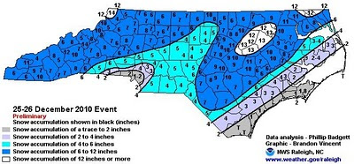
Here is the compiled snow total map from the NWS. Notice every county in the state of North Carolina had at least some snow on the ground. That is a rare occurrence. The totals from the New England States are very impressive.....numerous spots over 25" and 30"!

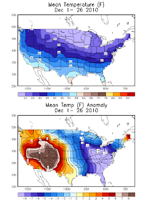
It has been a cold month of December.....that's an understatement. It has been a rare combination of factors that have given us this cold month, including a strongly negative NAO and negative AO as well as tremendous blocking in the higher latitudes that allowed for continually dumps of true arctic air into the eastern US. Here is the temperature average and temperature anomaly map for the month through Monday.


Gradual moderation will continue this week with some 50s for highs by New Year's Eve and maybe some lower 60s for the first day of 2011.
However, I still think most signs are pointing toward a return to colder air as we get deeper into early January. The NAO will stay negative, and that often favors cold air in eastern North America. The arctic oscillation (AO) looks to stay largely negative as well.
And, while we will not have the volume of storm systems we have during, say, an El Nino winter, I see no indications of just a simply dry pattern. We will still likely have storm system chances from time to time.
Basically, I am saying this.... All of the above average temp forecasts for January that were put out in the various winter outlooks (including mine!) could be in jeopardy. We will see....
Tidak ada komentar:
Posting Komentar