Jumat, 31 Desember 2010

New Year's Eve....

A big storm system is wrapping up in the middle of the country this morning. Heavy snow is flying in Nebraska and a tornado watch is up from NE Oklahoma to Missouri.

Heavy snow will spread through the High Plains into the upper Midwest today into tonight. At the same time, a pretty significant severe weather risk will ramp up through the Lower Mississippi and Tennessee Valleys.

For the Carolinas, this will be one of the nicer days this month with a good bit of sunshine and Piedmont highs into the 50s. Enjoy!

For any New Year's Eve plans you might have this evening, the weather will present no problems for you with come increasing clouds and temps settling into and through the 40s.

Not the prettiest of Near Year's Days tomorrow.....morning drizzle and some showers rolling in by the afternoon. The cold front will move relatively slowly through the region, some some light rain could even linger into Sunday morning.

Next week....

The weather looks pretty benign for at least the first few days of next work week. Highs and lows look to be at least relatively close to average, and it looks like the precip, at least into mid-week, will stay to our south and west.

I am still keenly eying the potential for a system around January 8, or Saturday week. Really, the overall players on the field look very similar to what we were tracking and watching for last week leading up to the Christmas storm system.

At this point, it very well looks like we are going to be watching for the interaction between a southern branch piece of energy and a northern branch piece of energy (phasing). The 0z European model phased those two streams just in the nick of time to provide a good snowstorm for north GA, E TN, and much of the Carolinas into Virginia. The GFS was close at 0z but way off with the 6z run. The 0z Canadian held the energy back in the SW much longer.

Below are two panels from the 0z Euro....notice on the first image in the upper-right panel, the southern piece of energy and the northern piece are interacting. The result 24 hours later (the second image) is a fully-phased, low pressure bomb going off just east of the Outer Banks.


This is far from anything to be excited about yet, but I remain in the corner of what I have had out here. The next time-frame to watch for potential fun and games is around January 8.
Kamis, 30 Desember 2010

Sizing up early January....

Here is today's edition of the video. In today's video, I take a look at a stormy finish to 2010 for the Lower Mississippi and Tennessee Valley, and where the pattern heads next week.


A little light freezing rain and snow is possible in the mountains this morning, but aside from that, the system pulling into the region today will only bring clouds. Highs today will range from 45-51 degrees for much of the Piedmont.

Lower Mississippi Valley severe potential tomorrow and tomorrow night...

Looks like there will indeed be a threat of severe weather from late tomorrow afternoon into the overnight hours tomorrow night, beginning in Louisiana, Arkansas, and Missouri and spreading into parts of Mississippi, Tennessee, and Alabama. Instability looks to remain somewhat limited, but shear and the wind fields will be significant, and some isolated tornadoes and damaging winds will be possible in those areas.

For the Carolinas, I don't think enough instability makes it into the region for any severe weather, or really even any thunderstorm potential. So, no changes here... I will continue to mention the chance of showers from later Saturday into at least Sunday morning. Slow moving front with the main dynamics well off to the north.

Chilly high pressure arrives Monday...many Piedmont spots probably in the 40s for highs.

I am eying the period around January 8 for the next chance of some wintry fun and games in the Southeast and/or the mid-Atlantic. See the video for a little more on this.

Rabu, 29 Desember 2010

Wrapping up a cold December...what does January hold?

Here is today's edition of the Carolina Weather Video. In it, I take a look at the December temps thus far, how our forecast is shaping up for the next week, and some January ideas...


Some updated info on the cold December, through Dec. 28. Here are the temp deviations from average thus far for the month.

CLT: -10.2
GSO: -8.7
RDU: -8.8
GSP: -8.1

Those are very significant deviations. Even though it will be a little milder the next couple of days to end the month, December will go down as one of the coldest on record. For instance, if the month were to end now, it would be the second coldest December on record for Charlotte.

We will see how the numbers sort out after the month officially ends.

It will be a bit milder to finish the week. Highs will be well up into the 50s Friday. Our next precip chance comes later Saturday into early Sunday as a cold front approaches.

Next week is interesting. The GFS is insistent on overrunning precip mid-week....we will see. Next week looks like the type of pattern where you have to watch for a sneaky little shallow layer of cold air oozing in from the north. But details are sketchy as to even a rain chance might occur.

At this point, I am not seeing blow-torch type warmth for January. The NAO wants to stay negative, and so does the AO. With that being the case, the chance of a long, huge ridge in the eastern US is slim.

Selasa, 28 Desember 2010

Gradual warming...

Here is today's edition of the Carolina Weather Video.....


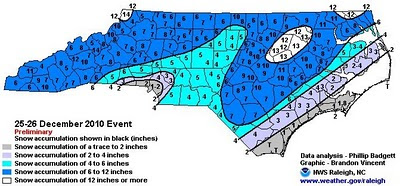
Here is the compiled snow total map from the NWS. Notice every county in the state of North Carolina had at least some snow on the ground. That is a rare occurrence. The totals from the New England States are very impressive.....numerous spots over 25" and 30"!


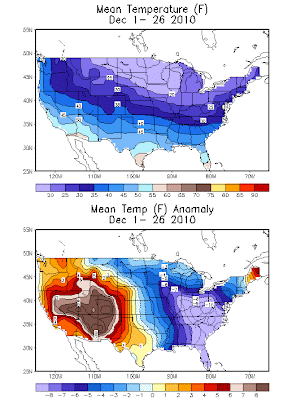
It has been a cold month of December.....that's an understatement. It has been a rare combination of factors that have given us this cold month, including a strongly negative NAO and negative AO as well as tremendous blocking in the higher latitudes that allowed for continually dumps of true arctic air into the eastern US. Here is the temperature average and temperature anomaly map for the month through Monday.


Gradual moderation will continue this week with some 50s for highs by New Year's Eve and maybe some lower 60s for the first day of 2011.

However, I still think most signs are pointing toward a return to colder air as we get deeper into early January. The NAO will stay negative, and that often favors cold air in eastern North America. The arctic oscillation (AO) looks to stay largely negative as well.

And, while we will not have the volume of storm systems we have during, say, an El Nino winter, I see no indications of just a simply dry pattern. We will still likely have storm system chances from time to time.

Basically, I am saying this.... All of the above average temp forecasts for January that were put out in the various winter outlooks (including mine!) could be in jeopardy. We will see....

Senin, 27 Desember 2010

Gradual moderation later this week...

Here is today's edition of the Carolina Weather Video....


Lots of snow still on the ground around the region after our Christmas weekend snow event. I am very happy that so many folks that wanted snow got it. And I also think it is incredibly neat to get snow on Christmas weekend.

Today will still be very cold with Piedmont highs struggling to make it above the freezing mark. It will also be breezy, adding insult to injury in terms of how it feels. Lows will be bitterly cold tonight....teens for most in the area.

Gradual moderation will take place later this week with some highs actually above average by New Years Eve. Some spots could be in the 60s for the first day of 2011. However, I don't think this is a prolonged warm-up with cooler air ready to move back in by Monday of next week or so.

January....

I see no sign of a 'warm' pattern coming for the eastern US. This is the week that pattern seems to be kind of reloading. However, the NAO and AO will remain negative, and we might even see the PNA spike toward positive. All of this, to me, indicates that more cold air is on the horizon.

It is very early in the winter season, so chances are, we have not seen our last winter weather potential. In fact, most of our winter weather events occur during the second half of winter, so tons of time to go.

What did we learn about the models from this most recent system?

First of all, the European model is still the model of choice in the medium range. It was the first to latch onto the idea of a big east coast storm. It had this idea while the GFS was indicating this to be a weak system that rode along I-40.

Admittedly, the Euro lost touch with the system a bit in the 2-3 day range, but it never completely lost the overall idea....it was just later with less impressive with any phasing.

The NAM is still clueless. Granted, I used it to verify the Euro ideas in the 60-84 hour range, but it totally lost touch with reality as the event neared.

The Canadian also had the idea of a big east coast system 4 and 5 days ahead of the event, but it too then lost the idea and never really got it back...at least in terms of the global model.

So, all in all, the Euro still led the way. And although it has its biases and can never be blindly trusted, it definitely means if we see something on the Euro for a few runs in a row, that idea probably has at least some merit.

But here is the thing that I think gets lost more and mote in meteorology today. The models are just tools for the meteorologist to use. So few times nowadays do people look at the actual weather and compare that to experience from the past. That is where real meteorology comes in.....not just reading models.


Minggu, 26 Desember 2010

Christmas weekend storm system slowly pulling out....

I hope everybody had a great Christmas. Many folks around the region got the treat of a white Christmas, although around the Charlotte metro, it took until evening to get the snow in.

The big coastal low continues to rapidly strengthen this morning, and it will continue to lift slowly up the coast. The band of moderate to heavy snow on the backside of the low will continue to gradually lift east and northeast out of the Carolinas, but it is a slow process.

All totaled, the Charlotte metro looks to have 2-5" or maybe 6" in some spots. For the Triad, 4-8" looks to do the trick, although there are some localized variations. The Triangle area looks like 5-9" with even some higher totals possible in a couple of spots. The system will even end as snow for the Outer Banks. This might be one of those rare systems where every NC county at least sees snow.

It will be very cold and blustery today and tomorrow. Highs will struggle to make it above the freezing mark today and tomorrow, and lows tonight and tomorrow night will drop into the 15-25 degree range around the Piedmont.

A big warm-up is on tap later in the week though with highs by the New Year in the 60s.

Jumat, 24 Desember 2010

Merry Christmas

Posting this just after midnight on Christmas morning.....WAY past my bedtime! But I wanted to put out a few quick thoughts.

The modeling has, as a whole, gotten quicker with the phasing of the two pieces of energy I have been discussing here all week. This is resulting in a stronger system with heavier precip thrown back into much of the region.

I have not had nearly the time to deeply analyze things as I would normally have, but there general idea here is for precip to spread in from west to east as the day unfolds. Initially in some spots, it could be a rain and snow mix, but snow will take over in time.

It now looks like much of the region....mountains, foothills, Piedmont over to I-95 will see at least a good period of moderate snow later Christmas into the evening hours with some heavy snow possible at times.

As the coastal low really begins to crank overnight into Sunday morning, some good snow rates are possible, especially in the eastern half of the Carolinas. And I still think this will at least end as some snow for the coast.

I am not going to draw up a map, but I would just put out a general 2-5" snow for much of the region (Carolinas). I know that is a broad range, but this is a changeable situation, instead of trying to get overly cute with it, I will go with that for now. Some areas will certainly be nearer the 2, but some could definitely be near (or possibly exceeding) the 5, especially in the deformation band as the coastal low cranks. In fact, odds seem to be that there will wind up being a strip of 4-8" somewhere.

We will see if any further westward trending commences. If so, that would certainly aid further in the Piedmont snow totals.

I will be spending time with my family as Christmas unfolds, so you probably won't hear much from me until late Saturday night or Sunday morning. Everyone enjoy the idea of waking up on a Christmas morning with the opportunity for some snow. For snow fans, I hope it works out for you. Tricky, tricky system, but the potential is there.

Merry Christmas, and God bless....


Christmas Eve...

First of all, I thank all of you for stopping by, reading, and watching the videos. It is incredibly humbling, and I appreciate you deeply.

I want to wish you and yours the warmest and merriest of Christmases. Take some time, enjoy family and friends, and reflect on all of our blessings.

In terms of our Christmas storm system, this one has been mentally exhausting. It is always fun to track these possibilities, but this one has been an especially difficult challenge. And still is frankly.

Most of the modeling is indicating some degree of phasing between the disturbances, but it is too late to really give a good snow to the western Carolinas (mountains will get their typical upslope though to help).

As it stands now, it looks like a band of mainly very light snow or flurries (maybe even sprinkles in a few spots the farther south you go) will try to move in as Christmas Day. unfolds. This would likely be in the 'token' or 'novelty' category.

As more of the upper level dynamics get involved by late Saturday afternoon and evening, there could possibly be a brief period of some moderate snow in parts of the region...maybe a near or east of I-85 over toward I-95. You will likely be able to watch the low pressure strengthening as it lifts up the coast later Saturday night, and to the northwest of that low, there will likely be a band of fairly decent snow for a while somewhere in the eastern half of the Carolinas. I still think even the coast, especially NC around the OBX, could end as a period of snow Sunday.

Elsewhere, I suppose anybody is fair game to pick up some snow showers Sunday with tremendous upper level dynamics overhead. I guess it is always possible if you happen to find yourself under a good enough snow shower to get the ground whitened for a bit.

Another quick disclaimer here...the quicker the system tries to phase, the farther west the area of steadier snow could make it Saturday evening through Sunday morning. But at the moment, most indications seem to be it will not happen in enough time to push that back into areas north and west of I-85.

So that's how it looks now. I will be out and about much of today, but I be checking in and take a look at things before tonight. If time allows, or if something overly interesting pops up, I will try to post an update.

Again, I thank you so much for stopping by. Merry Christmas, and God bless....

Kamis, 23 Desember 2010

Details still up in the air....

Below is today's edition of the Carolina Weather Video. Give it a look...


First off, I was a little surprised to see the modeling scatter so much with the 0z runs today. With the 12z and 18z runs yesterday, there seemed to be a lot of consolidating of the array of solutions. However, with the 0z runs, the models really diverged pretty widely in how each handled the interaction of our southern stream and northern stream disturbances. Even the European, which had been rock-solid consistent, differed somewhat from its previous runs.

This is the issue I have been laying out here on the blog for you all week. We are dealing with timing the interaction of two separate pieces of energy....one from the northern Plains....the other from the Pacific (now in Arizona this morning).

In terms of the modeling specifics, I don't know that any of the models really did a good job of capturing the strength of the AZ disturbance with the 0z cycle. Hopefully the AZ disturbance will be better sampled in the 12z cycle later today.

At the moment, I am completely discounting the NAM. It has essentially had 3 different looks its last 3 runs, so it is all over the place.

I am also largely discounting the 0z Canadian. It appears to weaken the AZ disturbance far too much as it enters the Plains states early tomorrow.

I have spent a ton of time comparing the most recent (0z) run of the Euro to its previous 12z run. There are really pretty similar overall. The one big difference is that the disturbance moving in from the north is a little less consolidated and strung out toward the Ohio Valley. The system still phases, but about 6-12 hours later than the previous runs. So, you still get a rapidly deepening low riding up the coast, but just later in the track than its previous runs. Therefore, the heaviest snow is all east of I-85.

As I have stated, the devil is in the details. If the northern branch feature is weaker or more stung out, this will not phase in time for a big snowstorm in the southeast.

Here is the general idea for this morning...

Snow still looks like a good bet around much of the region Christmas Day into Saturday night. I still like the chances of accumulating snow in a good number of spots. For the time being, I think the idea of the 12"+ snow dumps that had been indicated on some modeling seems even less likely now. That was always a long-shot. While it is still within the realm of possibility, odds seem to be favoring any potential for that shifting up toward New England if at all.

But, the general idea of some snow spreading into the region Christmas Day into Christmas night still seems good. At the moment, I envision a scenario where mainly light snow pulls in during the day Saturday, and then an area of moderate snow develops in from the southwest as the coastal low gets going. Where that moderate snow spread in will receive the highest snow totals.

Like there almost always is, there will be a strip of heavier snow totals, but pinpointing that location right now is impossible. Initial impression might be somewhere near or just east of I-85 to a little east of I-95, but again, that is VERY, VERY preliminary and certainly subject to change.

Like I said earlier, I think the 12z runs will begin to clear the picture a bit. Let's see what they hold....

Rabu, 22 Desember 2010

Late Afternoon Update

Just a few quick words here. Most modeling continues to gradually step toward the European solution, which came in with another huge snowstorm with its most recent 12z run. So, the idea I continue to go with is a less extreme version of the Euro model.

It looks like this low will likely bomb out pretty rapidly as it begins to move from the Gulf up near or along the Atlantic coast. This will likely be one of the more impressive coastal lows we have seen in a while.

Here is the trick though....there could very well be a sharp western cutoff to the heavy snow. I can fully envision a scenario where Columbia and Raleigh get significantly more snow than GSP, Charlotte, and Greensboro. But, if this really turns into a monster storm, there would likely be some significant orographic enhancement in the western Carolinas (orographic and due to lee side trough development).

So, all in all, I am staying the course, and I find it encouraging that the 12z modeling has trended even closer to the Euro...while the Euro holds its course. But again, I think the way to go at the moment is with a less-extreme version of the Euro....but I am fully aware that the Euro could very well verify.

Be aware that if this system really cranks, travel could become very difficult if not impossible around portions of the Southeast and mid-Atlantic by Saturday night and Sunday.

**Looks like the 18z GFS continues to look even more like the Euro solution, albeit quicker and not quite as intense. But the trending continues....**

Christmas storm coming slowly into better focus

Below is today's edition of the Carolina Weather Video....give it a watch...


The GFS finally caved to the general track idea of the foreign modeling of our Christmas storm system. However, it is still much weaker overall with the system than the other modeling. See the video above and I will show you why I think it is likely incorrect.

The European modeling continues to steadfastly hold on to the idea of an historic snow storm across the Southeastern US Christmas Day and night, gradually moving up the eastern seaboard Sunday and Sunday night. At face value, places like Huntsville, Nashville, and Atlanta all see snow with this, and the amounts really begin to ramp up once you get into the Carolinas. GSP, CLT, and GSO do very well in terms of snow totals, and the amounts get mind-blowing as you head to Columbia up to RDU. Just like previous runs, the Euro even brings snow prior to the end of the system all of the way to the coast and Outer Banks.

The Canadian too is weaker with its 0z run. However, it too looks to weaken the southern stream system too much as it enters the Plains states.

The UKMET is fairly far south with the system as well.

I will say it is a caution flag to me that a lot of the other modeling is less extreme than the European.

So, what does all of this mean?

Again this morning, I continue to lean my forecast in the direction of the European model....just a less extreme version of it. The European model continues to show textbook examples of explosive phasing and the resultant bombing of the low pressure area. And I do think that is a possibility.

However, to me, that appears to be kind of the extreme end of the spectrum, while the 6z GFS is the extreme in the other direction.

My forecast will continue to reflect snow potential in much of the Carolinas beginning later Christmas Day into Christmas night....even much of Sunday if the Euro is correct.

It is still too early for accumulation estimates, but just know the potential is there for significant accumulations somewhere around the region.

Also, please keep in mind the cautions I put out yesterday are still in the forefront of my mind. This system depends entirely on the phasing of two pieces of energy....one from Canada and one from the Pacific. The degree to which these disturbances phase, and the speed with which they do so will determine the outcome of this system. These are details that it is impossible to have confidence in yet.

Selasa, 21 Desember 2010

All eyes on the Christmas storm...

Below is today's edition of the Carolina Weather Video. Give it a watch.


A few areas saw a bit of snow last night, and in a few places, it was enough to lightly dust the ground. This was with a weak disturbance that is not exiting the region. A few sprinkles are possible tonight and tomorrow, but no big deal.

Christmas storm...

In terms of the modeling, the GFS remains the farthest north model of any of them. Let me say right off the bat.....it could be right. We are dealing with the phasing of two short waves....one diving down from the High Plains and the other that ejects from the Pacific and moves into the Deep South. If those phase early on in the game, the GFS could be correct. However, at this time, I continue to lean my forecast in the direction of the foreign models. It is worth noting that the GFS's own ensembles remain well south of the operation model....even up through the latest 6z run.

For snow lovers, the oz runs of the Canadian and European were a beautiful sight. Both painted a very snowy scenario Christmas Day from the Tennessee Valley right up through the Upstate and midlands of SC and most of NC.

The UKMET was even farther south, indicating any phasing between the disturbances would be much slower.

As I mentioned above, like I did yesterday, I am leaning my forecast heavily in the direction of the foreign models. For my public forecast on News 14, I am going with no precip on Christmas Eve with snow chances arriving Christmas Day.

What can go wrong?

Lots. If the two disturbance phase early, then a more northerly track would occur, meaning rain for most from the Carolinas southward.

If they phase too late or not at all, a very weak, suppressed system would result, meaning very light precip amounts.

However, if we thread the needle, like the Canadian and Euro have been showing, the result would be a once in a lifetime type of Christmas snow in the Southeast. But PLEASE keep in mind it will take near perfect timing to get these disturbances to interact at the right time for this to happen.

I am not going to commit to any specifics at this point. It is just too early, and too much can go wrong. But I will continue to go with the idea of some snow being possible around the region Christmas Day.

Senin, 20 Desember 2010

Christmas week...and a Christmas storm system

Below is today's edition of the video....give it a look....


A couple of items before I get into what everybody wants to hear about....the Christmas storm possibilities.

A total lunar eclipse will occur during the overnight hours tonight.....greatest eclipse will be at 3:16am. Astronomically, North America is in about as good a position as we could be in to see the eclipse. In the Carolinas though, we will have some clouds rolling in, but hopefully enough breaks to allow it to be seen if you so choose.

This is Christmas week obviously, and the weather will remain pretty quiet for our region through Thursday. Most highs will be in the 40s with lows mainly in the 20s.

A weak system will move through tomorrow, but it will only being clouds to the Piedmont....maybe a little light rain in the mountains.

Christmas system...

Lots of people already buzzing about the potential for a storm system Friday into Saturday. The system definitely has piqued my interest.

Here is the disclaimer. Here on the blog, I kind of pull back the curtain and just lay out a lot of the behind the scenes stuff. I like to discuss possibilities with you and let you know some of the things I am looking at.

The operational GFS is the farthest north of all of the modeling. Even the GFS's own ensembles are farther south than the operational run. Taken verbatim, the operational GFS shows a little light snow north of I-40 as the system arrives by Friday night, but then a mainly rain event in our region.

All of the others models I can get my hands on this morning show a farther south and stronger solution. If you were to give me a blank map and a pencil, I could not draw up a better setup for Southeast snow than what the 0z European model shows. It was a thing of beauty for snow fans. Its ensembles were largely in agreement, and the Euro not only brought snow Christmas Day to the Carolinas, but all of the way up I-95 into the Northeast.

The UKMET and Canadian all also indicate at least some snow being involved at some point in the system for much of the interior Carolinas.

Hear this....the system is 5 days away, and there are two main things to watch with this system.

1. The latitude it takes west to east across the US.

2. The phasing between two different streams.

When this phasing occurs, and how much phasing occurs it at all, will play a huge role in the track of this system. It is within the realm of possibility that this system winds up trending north with time. There is also the chance of very little phasing and a weak system sliding out to sea.

Way too early for any confidence, but it sure is fun to watch.....

Sabtu, 18 Desember 2010

Midday...

Had enough snow with sleet mixed in to dust the ground in much of the I-85 corridor in Cleveland, Gaston, and into Meck county and the surrounding areas. Radar doesn't look terribly promising for anything north and west of I-85 in the Triad, and frankly, the precip looks to be pretty short lived in the Triad viewing area where it does occur.

Watch the radars....this event will wind down from west to east, and that will be about it for this event. Doesn't look like there is much opportunity for any further development after the current wave. So, folks that saw something....enjoy! Folks that didn't....let's look for the next one.

Saturday Morning....

Good morning! Wanted to put up a quick post about what remains a pretty low-confidence forecast.

It looks like a good portion of the region will see at least light precip move through at some point today. The total amounts of precip with this one look pretty low overall until you get down into central and eastern SC and eastern and SE NC.

For the Charlotte area, looks like I am just going to have to go with the wording of a light wintry mix today....the mix being rain, sleet, and snow. A lot of the precip types will depend on precip rates. Temps are tricky....the area is in the 30s now, and I question exactly how much warming can take place.

This evening, there could be a final push of some light to moderate snow pivot through the region, and I suppose some places could pick up some minor accumulations.

For the Triad, same general idea, although there might be less rain in the equation. There is a little better chance of picking up some small accumulations in this area, especially as we head into later this afternoon/ evening.

The winter weather advisory for the Triangle put out by the Raleigh NWS is probably placed well. I still suppose the Triangle area has the highest potential of picking up some accumulations with this.

Also note there is the potential for a short-fused winter weather advisory to be popped out about anywhere around the region as we see how the precip shield will develop.

**Just laying the cards all out on the table here....this is about as low a confidence forecast as I have put out in recent memory. I have very little confidence on where the heaviest precip areas will set up, not to mention what the exact thermal profile will be. When you are dealing with a degree or so difference at 3,000 to 5,000 feet in elevation determining precip types, and in situations like these, the rate of precip plays a big role, saying it is a challenge is an understatement. But I guess that is what makes it fun. This system has been a booger from the word 'go.'

With all of that said, this is not a huge winter storm, and many people will not see any type of accumulation at all. But it sure is fun to watch.

Jumat, 17 Desember 2010

Friday afternoon...

The 12z models have not shown any more amplification with the weekend system....in fact, some show less.

I will continue with the same ideas I had on air this morning. Please see the map in the previous post below. The best chance of seeing some flakes lies between I-85 and I-95 starting northeast of Charlotte, and the best chance of seeing accumulations is from around the Triangle up into southeastern VA.

It just appears the system will not amplify enough to spread precip back into the foothills or much of the western Piedmont.

Again, see the map below for the best zone of seeing a few flakes tomorrow evening.

Standard disclaimer....there is always the chance of a last-minute northwest trend. However, I saw no indication of that as of the 12z models.

**The 18z NAM has come in with a more amplified system and QPF pulled farther west. Then again, it is the 18z NAM. We will see what 0z holds tonight.**

Potential weekend system....

Here is today's edition of the Carolina Weather Video. . .


Through about 9am or so, icy roads will remain a possibility, generally along and north of the I-40 corridor. This is from the re-freezing of water on the roads from yesterday's wintry precip.

Highs will top out in the 40s today with a partly sunny sky.

Weekend system...

After the trend with the 12z models yesterday was toward a stronger, more amplified system, the trend with most of the 0z and 6z data was toward a weaker, slower-phasing system, and therefore, a more easterly track.

You can see the map below I am going with on the air this morning. As it stands now, I think the best opportunity in NC of seeing snow is roughly between I-85 and I-95....with the best chances being around the Triangle up into eastern VA.

Now this is still subject to change as we are still 24-36 hours out, but this is how I see it as of now. If the system were to phase more quickly, then places west of I-85 could get into the action. However, that has not been the trend on the modeling over the last 12 hours.


Christmas week....

We stay on the chilly side of things next week. We will not be as cold overall as this week, but temps will remain below average.

A clipper will move through mid-week, and then another will arrive around Christmas. We will see what the precip chances are as we get into next week.

Kamis, 16 Desember 2010

Late-morning...

The winter weather event continues to wind down around the region. Freezing rain was the biggest issue in NC, and roads became very treacherous, especially Hwy 64 and points north.

Temps will slowly climb above freezing this afternoon, so road conditions will gradually improve.

The latest NAM has inched the Sat/ Sat night system westward a bit. I will take a long look at that one in the products tomorrow.

Lots of live weather....time for a nap!

Winter weather this morning...

A wintry mix is occurring around the region this morning. I am live on the air for the Triad market....Matt Morano is handlign Charlotte, and Lee Ringer is in the Triangle. Our operation is in full swing this morning bringing you tons of live weather, traffic, closing information, and reports in the field.

The teeth of the system will move through between now and late morning, and this is when precip will be at its heaviest.

For the Charlotte area, a mix of sleet and freezing rain/ drizzle with be with us until around mid-morning. Most temps should then get above freezing, and the afternoon and evening will then feature the chance of some drizzle from time to time. A glazing of sleet and freezing rain will remain a possibility. Road conditions will be tricky, especially on the secondary roads and overpasses.

For the Triad, snow and sleet will continue to change to mainly freezing rain this morning. A glazing will continue to occur on most surfaces. This afternoon, temps will get above freezing and road conditions will readily improve.

Rabu, 15 Desember 2010

Wed PM update...

I am focusing on our system tonight and tomorrow. The picture for the weekend potential system will get clearer once this current system passes and the responsible disturbance gets on the RAOB network.

Winter Weather Advisories are our for GSO, CLT, the Triad, and Triangle. Winter Storm Warnings have been hoisted up in VA down into Surry county and the NW NC mountains.

The latest NAM did shift the axis of heaviest precip south 30-50 miles. There have not been any huge changes on the WRF or the regional Canadian.

Here are my thoughts as of this afternoon.

A quick-hitting shot of sleet and snow will develop into much of the Upstate and Piedmont after midnight tonight. Some accumulations are possible, but south of I-40, it will probably be pretty minor. A dusting....maybe an inch in a few spots in the southern Piedmont. Maybe one or two spots with a little more, especially the farther north you go.

In the southern Piedmont, any remaining precip should transition to sleet and rain or freezing rain as the morning unfolds, and a glazing is possible in some areas.

For the CLT region, this is not a huge winter storm. However, I still think the potential is there for some road issues to develop. Ground and road conditions are quite cold, and it only takes a tiny amount of mixed precip to cause sizable road issues....just ask the folks in Mississippi and Alabama today.

Farther north, from roughly I-40 up to near the VA border....I expect front-end snow to transition to some freezing rain in time tomorrow. By the morning rush, there could very well be an inch or two of snow and sleet on the ground in many Triad locations. A glazing is then possible on top of that. I fully anticipate the possibility of some travel issues by the morning commute in many Triad locations.

Near the VA border and on up into VA, this will likely be where the meat of the storm rolls through. In that area, I would not be at all surprised to hear of some localized 4" or even 5" reports.

That's it for now. I will be in the wx office dark and early in the AM. Get up a little early and check the weather, road, and closure situations in the morning.

Winter weather chances....

Here is today's edition of the video. I encourage you to watch it...sometimes pictures are worth tons of words....


First off....wow, another bitterly cold morning. 10s everywhere and even some single digits in a few Piedmont locations. It will stay cold today with Piedmont highs in the 30s.

Next system...
Our next system will begin to arrive later tonight. Winter Weather Advisories are up from northern Mississippi and Alabama into the Ohio Valley. A Winter Storm Warning is up for eastern KY and NE TN. A Winter Storm Watch is up for much of VA down into the VA border counties of NC and up into the northwest mountains.
For the Carolinas, precip will spread into the I-85 corridor during the pre-dawn hours. This initial wave of precip will likely be some light snow and sleet for many. From south to north, and precip will kick over to a sleet and then freezing rain or rain scenario, depending on the surface temp in your back yard.
For the Charlotte region (and extreme northern SC), I can't rule out a brief dusting or a light, minor glazing early tomorrow. The precip just looks too limited for anything overly significant however. But, it is possible a few issues could drop up for the morning commute. Ground and road temps are cold, so it would only take a little freezing rain to create some issues.

For the Triad, there will likely be a period of snow and sleet that will gradually transition to some light freezing rain or rain. For the immediate I-40 corridor, I will go with a dusting to maybe 2" or snow and sleet with the possibility of a minor glazing before the precip ends.
More significant accumulations are likely up near the VA border and up into VA. For the VA border counties, I will go with 1"-3" with locally higher amounts....and again, a glazing possible on top of that.

**Hear this.....it is quite possible that the amounts will verify on the lower ends of those ranges given. Moisture is limited and the air is dry, so that will be an issue for precip to overcome.**

Here is the bottom line. This is not a huge event, but it could definitely play a role in the morning commute tomorrow, especially the farther north you go. So get up early, check the road and weather conditions, and of course, we will be like with updated information here on News 14 Carolina.

Here is the map I am using on air this morning....

Saturday/Saturday night...

The trend in the modeling over the past couple of cycles has been toward a weaker, less amplified system. With that said, there is still the potential for some snow in parts of the region. I will continue to take a closer look at this one as we near the weekend.

Selasa, 14 Desember 2010

Tuesday afternoon....

Just a quick check-in. Seems most modeling is trying to shift that axis of heaviest precipitation Thursday AM to the areas along and north of I-40. That is not set in stone, but the trend for this system today has been for most of any potential issues to be confined to the northern half of NC. But, this is a fine line in terms of where this axis of precip spreads in, so I wouldn't write off any specific area just yet. Remember, it was just the 0z NAM today that brought a nice little event to much of the region. Just watching the trends today though....

For the weekend, I still think the potential for this one is very much alive. The GFS continues to indicate a significant system, but there are temp issues for snow fans in the southern Piedmont. The Canadian is weaker and farther east.

The latest Euro is very, very close to developing the system into a biggie. But it keeps the upper level energy a little too strung out, and therefore keeps the system as more of a weak wave of low pressure as opposed to a bomb going off. However, gut feeling on this one is that it trends into a more significant system somewhere in the region. Might wind up being the Virginias that see most of the snow if it winds up really bombing out. However, at this point, I think everybody is still in the game on that one, and all options (from the weak wave, farther east scenario to the strong, deepening low, farther west scenario) are still on the table.

Really impressive cold....

Below is today's edition of the Carolina Weather Video....give it a look.


This blast of arctic air is very impressive. Highs today will be at least 20 degrees below normal again across most of the region, and many Piedmont spots will again fail to reach freezing. In fact, the Triad region will likely not make it out of the 20s. All of this will full sunshine today.

Lows tonight will again be in the teens. So keep those faucets dripping and the outside pipes wrapped.

Next system...

The NAM (one of the shorter-range models) continues to bounce around where the heaviest axis of precip will be with the next system late Wednesday night through Thursday. This lowers my confidence.

As it stands now, I will still mention a light wintry mix being possible across the Piedmont from very early Thursday morning until late morning or midday....any precip after that would try to fall in the form of light rain or drizzle in many places.

Will this be a huge deal? Probably not. But wherever that axis of heavier precip does impact, some accumulation is possible. Where is still the question.

Weekend system?

The potential for a storm system around Saturday is still very much on the table. However, the models continue to show a high degree of variability in their handling of this system. The GFS is still the most impressive with it while the Euro is still a little out to sea and weaker.

If the GFS is correct, parts of the region could see a rain changing to snow scenario Saturday and Saturday night. But I am far from confident at this point.

Senin, 13 Desember 2010

Frigid...

Below is today's edition of the Carolina Weather Video...


First of all, I want to thank my buddy Andy Wood for putting up some great content here on the blog while I was away. Interesting stuff. Andy is a meteorologist at the Fox station in Greenville-Spartanburg, and you can read his stuff anytime at the Fox Carolina Weather Blog.

Bundle up.....we are in the grips of another huge blast of true arctic air. We had some light snow pinwheel through yesterday evening, and it was enough to whiten the ground in some spots. However, the cold is the big story.

This is impressive cold, and some Piedmont spots will not see temps above freezing again until Wednesday afternoon. Highs today will struggle to make it into the low to mid 30s, and many spots will do good to see lower 30s tomorrow. It will remain blustery, especially today, with winds gusting to 30 or 35mph.

Overnight lows will dip into the dangerously cold category. Lows tonight and tomorrow night will be in the teens across the Piedmont. When you factor in the wind tomorrow morning, we will be looking at single digit wind chill values.

Next system...

Our next storm system will roll through Wednesday night into Thursday. Now, this does not look to produce huge amounts of precip, however, there is enough there to catch your attention. The airmass across the region, at least initially, will be cold enough to produce a wintry mix with some spots possibly kicking over to rain before the precip ends Thursday.

It is still a bit too early for specifics, but some accumulating wintry precip is possible.

Weekend system???

Various models at various times have produced a big winter storm for parts of the Southeast over the upcoming weekend. However, I have zero confidence in that possibility yet. We are dealing with relatively small-scale features in a fast-moving flow pattern, and any range of possibilities (from cold and dry to significant wintry precip) are on the table. We will see....

Kamis, 09 Desember 2010

Forecast Model Comparison


Model Comparison: Some details are beginning to surface. One of those is a strengthening trend with the upper-level energy as the tilt of that energy pivots... the more the tilt is to the RIGHT, the better the chances of the cold air cooperating with the precipitation. I have drawn a "black line" to mark the tilt and it bisects the center at "X" or "N" of the upper-level energy responsible for producing precipitation and bringing in the cold air. The maps show corresponding upper-level energy and precip (same timeframe).

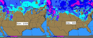
Also, as Matt has pointed out many times, when a cold snap presents itself... it's important show the increase in US snow-cover. That increase is obvious since November 19th.

Reason for posting the map bbove is to emphasize next week's cold snap. The arctic air in the forecast for next week will travel over a vast amount of snow cover. A considerable area of 4-8" currently exists in the upper midwest and 4-8" also exists in Western NC. Most of that snow has been produced by this latest cold snap. More snow will also fall from the low pressure system headed toward the Great Lakes on Saturday. Numbers will come crashing down. December standards (averages) won't be touched and records may fall next week.

Weekend Storm... A Lot of Bark, But How Much Bite?

Saturday: Cloudy with rain possible very late, but most of it holding off until Sunday morning. Highs 52-56 around Charlotte & 51-54 northern Foothills.

Sunday: This one is complex! The storm system creating all the buzz will move toward the Great Lakes Saturday evening and produce a strong cold front advancing through the TN Valley Sunday morning. Rain will move in Sunday morning as snow mixes in along the ridgetops of the NC Mountains and some sections of the NC Foothills. Again, rain will move in first. That is the main focus of the weekend forecast, yet will probably be OVERLOOKED from now until Sunday.

Now that all the seemingly boring "rain talk" is out of the way, the focus shifts to cold and the possibility of… well ______ . ***Snow will fall in Western North Carolina (mainly above 3000') and will accumulate… with a rough estimate on accumulations at 2-5″. Even though I'm not real familiar with the foothills area, I do think Hickory gets snow in this situation, as does the Burke County area near Morganton. Not only accumulating snow, but high winds driving wind chills at or below zero!*** I also feel good about snow in North Georgia due to a somewhat limited dry-downsloping effect from lesser elevations of southeast TN. I have to tell you that I'm usually optimistic about snow chances when they present themselves, but As of yet, I haven’t forecasted accumulating snow for the Upstate of SC. In this situation I’m glad I haven’t. Here’s why:

2 things:

(1) As many people know, the NC Mountains have a major impact on the Charlotte area (in a westerly or northwesterly wind situation). Forecasters can’t ever discount this area’s topography and it’s impact on storm systems. For snow in the Charlotte area, if you don’t have the storm system to your south (or along the coast) and you want snow, well it’s a stretch. This time we don’t… this system will be centered north of us as it tracks into New England. In this situation, a downsloping wind may completely knock out most of the precipitation unless the cold front and temperature gradient produces enhanced precipitation along the front.

(2) All models indicate a nice, uniform line of rain along this front. Word of caution: forecast models always lay out an eye-pleasing, uniform line of rain along the front… yet when the actual storm gets here it’s usually broken and ragged. That’s just the fact of the matter. A ragged line of precipitation makes a lot of sense when you consider that most of the storm energy will pivot north of us.

With all those things said, I suppose Charlotte to Greensboro will have a chance at a narrow band or quick burst of snow along the tail end of the system. That is, unless this thing shows a CONTINUING strenthening trend on forecast models, tilts further negative and allows for cold air intrusion quicker. Still, my gut says forecast models are optimistic on the moisture along the front.

I will have a model comparison of upper-level energy up shortly...

Selasa, 07 Desember 2010

Greenland Block = Brutal Cold on Monday

Lows This Morning: Talk about a BITTERLY COLD shot of air for Early December! Just as Matt forecasted and blogged about, towns hit rock bottom this morning as arctic air settled into the Charlotte area and the Triad. Somebody call that dude named Gore because temperatures were nearly 20-degrees below normal today! Here's a rundown of how cold temperatures were this morning:

Charlotte: 16

Hickory: 16

Asheville: 16

Winston-Salem: 19

Greensboro: 20

Starting Colder Wednesday Morning: As I write this (7:45ET), winds are calming a bit around the Charlotte area. Winds dying down overnight combined with a clear sky sets up the perfect situation for more cold temperatures. I expect lows to range from 12 to 16 in most areas tomorrow morning as more dry air downslopes off of Mountains in Western North Carolina. With more sunshine and less wind tomorrow, highs may actually reach the upper 30s, but then again maybe not! Middle-upper 30s under a good bit of sunshine is a good bet in many towns.

Strong Weekend Storm, Then Stronger Shot of Arctic Air: Over the past few days, the focus has not only been on the present cold snap, but also a strong storm system poised to move in this weekend. For a time last week, some analysis had shown the upper-level energy diving into the southeast and spawning a coastal area of low pressure (out east of Chaleston). That's when the rumors of snow began, but those hopes ended fairly quickly in all areas outside of the high terrain in Western North Carolina once the GFS and European locked into agreement on more of a TN Valley to Ohio Valley storm track in the direction of the Great Lakes.

The first map below was pulled from today's 12Z run of the GFS forecast model. As stated on the image, this shows a projection of conditions for Sunday evening at 7PM. Beofre I get started on the cold, I do want to point out that there is a possibility of some severe storms Sunday morning given the position of the low and wind shear produced by the strength of the low. On the the cold air though... at 7PM on Sunday, a line of showers/possible thunderstorms will have already pushed through the Charlotte area with very cold air behind the rain. The 0C/freezing line at 5,000ft is projected to be east of Charlotte at that point as northwest winds kick up.

The second map projects conditions 12-hours later (7AM Monday). At that point, it won't be all that fun to be outside! Very cold northwest winds will likely be howling. More arctic air will settle in Monday and it will be VERY INTERESTING to note highs on Monday... may not warm much past of the lower 30s! The ridgetops northwest of Asheville are going to have to deal with more accumulating snow, although tough to tell on accumulations at this point. Also, I have a sneaky feeling that parts of the Western North Carolina Mountains will go under a Blizzard Warning for winds higher than 35mph along with that snow. It will be interesting to watch conditons play out up there as well!

The last map I have posted shows a comparison of the GFS and European forecast models at the same time - next Tuesday at 7AM. Both models are in good agreement of the overall setup. Both show a very sharp trough and brutally cold air for early December! Both also show a persistent Greenland block - strong ridge of high pressure nosing into eastern Canada. This is helping keep fresh supplies of arctic air moving south. Also, as I mentioned earlier, a relatively weak ridge near the west coast looks as if it will remain in place for early next week. If that ridge along the west coast were more amplified, it might be scary how cold things would be around here!

I will try to post a snow-cover somparison tomorrow... hope everyone is able to stay warm!


Senin, 06 Desember 2010

Frigid stuff....

Cold is the weather word this week. Many Piedmont locations will see highs shy of 40 for the next few days, and many lows will dip down into the teens. This is pure arctic air.

No storm system until we get to next weekend. Models still look all over the place with the exact track of that one, so tough to have any confidence at this point.

I will be out of town this week, but my buddy Andy Wood, a meteorologist at Fox Carolina in Greenville-Spartanburg, is kind enough to provide some information here on the blog this week. Andy is a bright meteorologist, and if you have never read his stuff, I think you will enjoy what he has to say.

Everyone have a great week. Throw another log on the fire and stay warm!

Sabtu, 04 Desember 2010

Quick Saturday AM post....

First of all, regarding the clipper...

Light precip has streaked out way ahead of the main system, and a few sleet pellets or snowflakes are possible this morning in some spots. But the main part of the system comes through late this afternoon through this evening.

At this point, I think there is a pretty good chance that some areas along and north of I-40 will see some elevated surfaces whitened by this evening. This would be on the grassy areas, car tops, roof tops, etc....roads should not be an issue with ground temps still above 40 degrees.

South of I-40, the thermal profiles (as well as the fact that moisture looks to have a hard time making it up into the dendritic growth region per BUFKIT soundings) look to support some light rain, maybe mixing with or ending as a few snow flakes.

The long an short of it....not a big deal at all....but maybe a few lucky snow fans in the northern and northwestern Piedmont will see some elevated surfaces whitened by this evening.

Here is the big deal....the coming cold......beginning tomorrow and lasting through Thursday or so. This is a big-time, sustained blast of cold air. I still think many Piedmont locations will see highs shy of 40 for a few days during that stretch with lows in the teens and 20s.

Jumat, 03 Desember 2010

Chilly today, clipper late tomorrow, frigid next week...

Below is today's edition of the Carolina Weather Video...


It will be another fairly chilly day today with highs in the Piedmont in the upper 40s to lower 50s under a partly cloudy sky. Lows tonight will drop into the upper 20s to around 30 degrees.

Clipper system...

A fairly potent 'clipper' system will drop into the region late tomorrow. Typically the mountains will wring most of the precip out of these types of systems, and this will likely largely happen once again tomorrow. However, this system is potent enough that I think some precip will make it into the Piedmont and even to the coast.

What type of precip? Generally speaking, I expect most of the precip (that will likely move in late in the afternoon for the western Piedmont and into the evening for areas farther east) to be in the form of some light snow for the I-40 corridor and points north. Some rain could mix in, but generally speaking, the atmosphere looks cold enough for the main precip type to be snow in those areas.

South of I-40, it looks like mainly some light rain with a few intervals of light snow possibly mixing in.

Now, the key work in all of this is 'light.' Some places will not see any precip at all, and in the places that do, it will not be very heavy. I do think it is within the realm of possibility that a few elevated surfaces could get dusted, but ground temps are still pretty warm, so any accumulation potential is limited to those elevated surfaces, and even at that, a dusting.

So, really, not a big deal, but kind of a novelty in that some places could see the first flakes of the season.

Big-time cold....

Here is the big deal....the cold air on the way. While it has been chilly the past couple of days, I am anticipating downright cold air to settle in for next week. I am talking many Piedmont highs shy of 40 for several days next week with lows in the upper teens to lower 20s.

This sustained cold blast will likely give most areas in the region at least 4 days of highs at least 15 degrees below average.....that is quite significant.

Kamis, 02 Desember 2010

Brrr.....

Below is today's edition of the Carolina Weather Video...


Cold air will be a common theme in our weather for at least the next week to ten days. The predominant weather pattern will feature a trough over eastern North America, and that will pull several re-enforcing blasts pure arctic air down into our region.

Today, a disturbance will move our way from the Plains states, but the system will be weakening as it approaches. So, while we will have a good deal of clouds overhead at times today, I don't anticipate any precipitation. It will be chilly though with Piedmont highs only in the 40s.

Weekend ahead...

Tomorrow should feature lots of sun, and highs will be a few ticks above today's values....upper 40s to lower 50s.

A 'clipper' system will swing through our region late Saturday and Saturday night. Typically, clipper systems do not generate much if any precipitation around the Piedmont. However, this one is pretty potent, and there could be just enough moisture available for the system to wring out a little precip.

So, at this point I will mention the chance of some light snow late Saturday and Saturday night, mainly along and north of I-40. South of I-40, maybe some light rain ending with a few snow flakes.

This does not look like a big deal....precip amounts look very light. However, we will keep an eye out to see if it looks like the system will tap any deeper moisture.

Next week....

It looks like 'cold' will be the dominant weather word next week. And I do mean cold. Highs on several days might not make it to 40 in some Piedmont areas, and lows most mornings will at least dip down into the low to mid 20s....and if we can get a night or two where winds relax, some teens are definitely possible.

As for the potential storm system, at this point it looks like cold will likely overwhelm the pattern in the eastern US, and the big trough will likely suppress any potential storm systems to our south. But we will watch to see if the trough will allow a system to get up our way at some point.

Rabu, 01 Desember 2010

Quiet, chilly weather settles in...

Below is today's edition of the Carolina Weather Video...


After an active night with numerous severe thunderstorm and some tornado warnings issued across the region, a chilly, dry, and quiet airmass is arriving today.

Temperatures will not move a great deal through the day. In fact, the temps will begin to fall a bit in many spots later this afternoon, and lower 50s will be about the best we will do for daytime temps. It will be a bit breezy as this colder airmass arrives as well.

A cold night is on tap with lows well down into the 20s area-wide. Then tomorrow will only feature mid to upper 40s for highs around the Piedmont.

Friday will be cool and quite with highs in the lower 50s.

Weekend...

A clipper system will swing through this weekend. With this morning's forecast package, I have again left precip chances out of the forecast. However, I can't rule out a brief shower in a few spots at some point over the weekend. Highs will remain chilly....mainly in the mid to upper 40s.

Next week...

Most modeling is indicating the potential storm system next week will remain to our south, and most of our region will simply be cold and dry. I am not ready to rule out the possibility of a storm system, but the trend has not been the friend of snow fans over the past 24 hours.

It does look cold next week with some low to mid 40s for highs and lows well down into the 20s. In fact, if the idea of a suppressed system (meaning no precip here) does indeed occur, some teens are quite possible for a few Piedmont lows.

Selasa, 30 November 2010

Mid-afternoon update....

A tornado watch has been issued for a good chunk of SC up into the Charlotte metro region of NC. The wedge has been successfully eroded away for most of the Piedmont, and the airmass is slowly getting more unstable. Most temps were in the 60s, and so were the dewpoints as of 2-3pm.

The sun is out in parts of GA up into parts of southern SC, and the airmass is rapidly getting more unstable there. Some of that unstable air will get pulled northward in the southerly flow ahead of the system.

The main band of rain and embedded storms will progress through the mountains and emerge into the foothills by early this evening.

Don't let the radar deceive you. The activity will probably not look terribly impressive as it begins to emerge out of the higher elevations. However, as the incoming dynamics interact with the more unstable air in the Piedmont and Upstate, the storms will likely intensify.

Damaging winds and a few tornadoes are the concern this evening into tonight.

Stay with News 14 Carolina on television for all of the latest information. And tonight is a perfect example of every home needing a NOAA weather radio.

Powerhouse system moving in...

Below is today's edition of the video...


The region will continue to see periods of rain today as a major storm system crawls into the area. The cool conditions we had in place yesterday will give way to a much milder airmass in time today, and most of the Piedmont will be well up into the 60s by later this afternoon. Some spots could even hit 70 degrees or so.

As the airmass gets more unstable, thunderstorms enter the forecast equation. While a few storms could be involved late this afternoon, I think tonight is the main time-frame for storms. This is a classic high shear/ low instability setup, and similar setups in the past have resulted in severe weather. We will have to be vigilant in watching for severe storms capable of producing damaging winds and even a few tornadoes tonight.

This is another case where the possibility exists over severe weather while the bulk of the community is sleeping. Every home should have a NOAA weather radio. If and when severe weather develops, we will be on the air covering it for you, but we can't wake you up through the TV sets. There is a chance this winds up being a non-event, but have a way of hearing watches and warnings in the event they are required.

Quiet and chilly weather resumes tomorrow through the weekend. A 'clipper' system will roll through Sunday and bring some clouds. However, the moisture still looks quite limited, and once again I have left precip out of the weekend forecast. Most high and low temps on a daily basis will be a little below average.

Next week...

Model madness continues for next week, and I still think there is the possibility of a storm system for the Deep South and/or Southeast Tuesday into Wednesday. I think the GFS is unusable for the time being (at least as of the 0z run today)....it over-amplifies things early next week over the eastern US and really crushes the disturbance that would create the storm system. The Canadian and European models both still have the system, and I think they are more correct. But time will tell....

Senin, 29 November 2010

Dynamic storm system on the way. . .


After some fairly chilly, docile weather Saturday and Sunday, the weather is about to get more active around here. Today, clouds will be on the increase for the Charlotte and Triad zones on up into the mountains, and some drizzle could develop in time. Highs today will largely be in the upper 40s to lower 50s.

The core of our next system will swing through later tomorrow and exit very early Wednesday. Rain will be a possibility from time to time tomorrow, with the heaviest rain during the day being the farther west you head....especially in the mountains and foothills. With time, the band of heavier rain will pivot eastward through the rest of the area. This will occur mainly Tuesday night. at that point, a few storms could be involved as well. This is a high shear/ low instability set up, and a few severe storms can't be ruled out, especially as you get closer to I-95.

Flooding will likely be an issue for the mountains and foothills. I fully anticipate some 3-5" rain amounts in those areas. For the I-85 corridor, this is looking like a 1-2" type rain event.

Later this week...

A fresh push of cold air will arrive later Wednesday, and highs will likely struggle to get out of the 40s in some Piedmont spots Thursday into the weekend.

A couple of 'clipper' type systems will move through late this week and then again Sunday. At this point, moisture looks pretty limited, so I don't have any precip chances in the forecast with those.

System next week...

It sure looks like another system will roll through the region Tuesday or Wednesday of next week. This is the one that has been hinted at by the modeling for a while now. That one definitely bears watching for the potential for at least some wintry weather somewhere around the region as a whole. WAY too soon for any type of details....but it has my interest.

Jumat, 26 November 2010

Cold front moving through today...

Black Friday began in mild, breezy fashion with Piedmont temps surging up into the 60s ahead of an advancing cold front. That front will continues to move through the region today, and we will continue to have the chance of some showers into this afternoon. A few rumbles of thunder can't be ruled out, but there is not enough instability in place for a big worry with thunderstorms.

Temperatures will begin to drop this afternoon, and by the time Saturday morning arrives, most spots will be below freezing.

Sunshine will abound tomorrow and Sunday with highs in the 50s. Lows will remain below freezing through Monday morning.

Next system...

Our next storm system will roll through Tuesday and Wednesday next week. Look for shower chances both days, and some storms look like a possibility Tuesday night into early Wednesday.

Much colder air will flow in here later Wednesday, and the rain could change to snow up in the mountains prior to ending. We will have another chilly, primarily sunny couple of days to finish next week.

Kamis, 25 November 2010

Happy Thanksgiving!

I want to wish everyone a happy Thanksgiving!

In terms of the weather....no the prettiest of Thanksgiving forecasts. We have somewhat of a cold air damming scenario in play today. The result is a lot of clouds and fairly cool temps. Piedmont highs will range from the mid 50s to lower 60s, and some light rain and drizzle is possible at times.

The wedge will get scoured out tonight, and that will mean steady or even rising temps.

Tomorrow, a cold front will slide through, and that front will bring some showers. So, as you head out to hit the sales, bring the umbrella. Highs tomorrow will actually occur during the morning with falling temps tomorrow afternoon.

Beautiful, albeit chilly, weather will unfold Saturday and Sunday. Piedmont highs will be 50s with lows at or below freezing. Both days will feature a sunny sky.

Next week...

Another storm system will roll through Tuesday and Wednesday of next week. Look for rain possibilities on both of those days with some colder air to follow by Thursday. That system could involve some mountain snow on the backside as colder air rushes in before the precip ends.

Rabu, 24 November 2010

Quiet for travel in our region...

Below is today's edition of the Carolina Weather Video.....


Today is the biggest travel day of the year, and if your travel plans take you anywhere around our immediate region, there will not be any weather problems for you. However, the travel trouble spot today is in the nation's midsection. Rain will occur from the Ozarks into the Ohio Valley. Snow will again fly from the Dakotas into Minnesota and Wisconsin.

For our area, we will see lots of sunshine today with cooler conditions than yesterday...most Piedmont highs will be between 60 and 64 degrees. Speaking of yesterday, a record high of 75 was achieved at the PTI airport.

Our Thanksgiving day is shaping up to be a cloudy, cool, and damp one. Highs will be pretty cool....only low to mid 50s in the Piedmont....and we will have a primarily cloudy sky. Some drizzle is possible at times as well.

Our next front will spread showers in from later Thursday night into Friday, especially Friday morning.

After that front clears, we will have a chilly, sunny forecast for the rest of the weekend. Piedmont highs Saturday and Sunday will be in the 50s with lows in the upper 20s and lower 30s. Highs will be in the 40s this weekend for many mountain spots.

Next week...

Another system will wrap up toward the Great Lakes and bring another cold front our way. Showers, and maybe a storm or two, will roll in Tuesday and Wednesday with a push of chillier air to follow.

The latest model runs have our system at the end of next week well to our north.

Selasa, 23 November 2010

Mild with a few showers possible...

Below is today's edition of the Carolina Weather Video....lots of good stuff in there....give it a watch.


Another mild day will unfold around the region today with highs in the lower 70s in many Piedmont spots. A cold front is approaching and will bring the chance of a few showers from this afternoon into this evening. However, rain amounts where the showers do occur will not be terribly impressive.

Tomorrow will be quiet around our region with lots of sun for much of the day and highs in the upper 50s to lower 60s.

Thanksgiving weekend...

Thanksgiving day is looking relatively cool and cloudy with highs in the mid to upper 50s to near 60. Some drizzle is possible, but no real appreciable rain.

Another cold front will slide through Friday and bring some rain, especially through the first half of the day. Then we are looking for full sunshine Saturday and Sunday with chillier temps. Highs should be in the 50s with lows in the upper 20s to lower 30s.

Next week...

It looks like we will have a system move through Tuesday or Wednesday and bring some rain. After that, more chilly air should arrive, and there is the potential for another system around the Dec. 4-6 time frame. The GFS keeps popping a system with the potential for wintry weather with that one....but all I can really say at this point is that yes, there *might* be a system around that time frame......but then again, the northern branch might wind up stronger and crush it. So, nothing too exciting yet. But it is interesting to watch.

Senin, 22 November 2010

Changeable weather....

Some computer issues at work this morning, so this will be brief....no video this morning...I will be back in my regular routine tomorrow morning.

Some stubborn clouds today were slow to erode, but all in all, a mild few days will unfold. Highs today are in the upper 60s to lower 70s, and we should see low to mid 70s tomorrow.

Once again tomorrow morning, clouds and some fog will be with us, but there should be at least a few intervals of sun.

A cold front will drop in by tomorrow night, and ahead of that front, we will have a chance of a few showers from late tomorrow afternoon into tomorrow evening.

For the big travel day Wednesday, no problems around here with sunshine and highs in the 60s. However, another system will bring some snow to the northern Plains and rain and storms to the Midwest and central Plains.

Thanksgiving weekend...

I think most of us will be able to squeeze out a dry Thanksgiving day, although we will see a good deal of clouds. Highs look to be in the lower 60s for most.

A cold front will progress through Friday, bringing the chance of some rain for the big shopping day.

Chillier air will settle in for the remainder of the weekend. Highs will be in the 50s at best Saturday and Sunday despite full sunshine.

Next week...

Lots of question marks as we end November and begin December. The week looks fairly cold for much of the US, and there are hints of a storm system or two. We will see. . .

Jumat, 19 November 2010

Fantastic weekend weather....big changes around Thanksgiving

Below is today's edition of the Carolina Weather Video...


We are back to full sunshine around our region today, and that will remain the case all weekend. Highs today around the Piedmont are in the mid to upper 50s to near 60. Highs tomorrow and Sunday will warm well up into the 60s.

Thanksgiving week...

The first few days of Thanksgiving week will be quite mild....upper 60s Monday for highs with some lower 70s possible Tuesday and maybe even Wednesday. However, that mild weather will then sharply change.

An arctic cold front will gradually settle closer to and eventually through the region later Wednesday and Thursday. A few showers are possible Wednesday, but it still looks like the best shower chances will be on Thanksgiving itself.

Much colder air will plunge in here by Black Friday....we might see some Piedmont highs shy of 50 Friday. The cold air only gets reinforced as we then go through Saturday and Sunday with highs and lows well below average.

How long will the cold last?

Good question. As of now, I think we will stay primarily below average for temps into early December, but there will be some modification at times.

Precip??

The GFS continues to pop up random snowstorms out there in fantasy land near the end of the cycle. It is certainly within the realm of possibility that somebody in our region will see some wintry precip during this upcoming colder pattern, however, I don't see anything specific for snow fans to get excited about as of now.

Kamis, 18 November 2010

Some clouds today....sun back tomorrow...


A storm system is pulling into the region today. However, it is rapidly weakening, and the precip associated with the system continues to dwindle with time. A few showers are possible up in the mountains today, and a few sprinkles might make it into the northern foothills, but that will be about it. Most folks will only see some clouds today. Highs will be close to average for the time of year...upper 50s to near 60.

Another chilly night is ahead with lows back down into the 30s tonight, then full sunshine returns tomorrow through the weekend. Highs tomorrow will likely be in the upper 50s with highs back into the 60s through the weekend.

Thanksgiving week...

Mild weather will be with us Monday and Tuesday to start the Thanksgiving week with highs in the 60s to even lower 70s at times, especially Tuesday. However, big changes are on tap later in the week.

A cold front will drop in here around Wednesday and begin to bring the chance of some showers. This will be a rather slow frontal passage, so it looks like the chance of at least some rain will extend into Thanksgiving itself.

Behind that front, arctic air will engulf the eastern US. This is the blast of cold air that I have been discussing in this space for quite a while now. It looks like Black Friday and the rest of the following weekend will be quite chilly. How cold? Still working on that, but at least several days of below average high and low temps....and the cold will likely be with us right on into early December.

Snow fans keep wondering about the possibility of winter weather. Nothing overly exciting as of yet. However, as we make the switch to the colder pattern, there are signs of the storm track being at least somewhat active. We will see....

Rabu, 17 November 2010

Sunshine returns!


It was a fairly rough and tumble evening across the region with showers and some severe storms. A number of wind damage reports came in all the way from South Carolina up into southern New England.

However, today we are on the back side of that departing low pressure area, and that means dry air has returned to the area. We will see sunshine all day with highs in the low to mid 60s. It will also be fairly breezy today on the back side of that low.

Our next system will swing in tomorrow, but it will be in a weakening state, and moisture will be very limited, so I don't expect any rain. However, we will have some clouds move through as our Thursday unfolds.

Another great weekend!

What else is new.....another great weekend forecast! Highs will be in the 60s with full sunshine this weekend. Morning lows will be in the upper 30s to near 40.

Thanksgiving week...

It will be a warm start to our Thanksgiving week with lots of sunshine Monday and Tuesday and highs warming into the upper 60s by Tuesday....even some lower 70s are quite possible.

However, a cold front will likely drop in here by Wednesday or Thursday, bringing some rain chances. Very cold air is waiting in the wings behind that front, and I will continue to say the window of opportunity opens for that cold air to drop in here as we go deeper into the Thanksgiving weekend.

Selasa, 16 November 2010

Showers, a few storms possible


An area of low pressure will lift from Mississippi this morning to Ohio this evening. We will be on the warm side of the system, so our region will continue to have showers roll through from time to time today.

A few storms are possible this afternoon into early evening, and enough dynamics are in place that a few storms could produce some wind damage or a brief tornado. The only ingredient lacking is instability, so this is something we will watch through the day.

We return to dry, quiet weather tomorrow with sunshine and highs in the 60s. Another weak system will swing through Thursday, but it will not have enough moisture to work with to produce significant rain chances.

Weekend...

Another great weather weekend is on tap. Look for sunshine and highs in the 60 both days...lows in the upper 30s to lower 40s.

Thanksgiving week...

Thanksgiving week will begin with some warm afternoon temps...probably some lower 70s for highs on a couple of days. However, very cold air has taken up residence in Canada, and that cold air will bleed into the northern US in time.

At some point, the pattern will likely buckle and send that cold air into our region. The window of possibility for that to occur will likely open right around Thanksgiving.